
Greater Manchester is a metropolitan and ceremonial county in North West England, with a population of 2.8 million; comprising ten metropolitan boroughs: Bolton, Bury, Manchester, Oldham, Rochdale, Salford, Stockport, Tameside, Trafford and Wigan. The county was created on 1 April 1974, as a result of the Local Government Act 1972, and has been covered by a combined authority on 1 April 2011. Greater Manchester is formed from parts of the historic counties of Cheshire, Lancashire and the West Riding of Yorkshire.
The Metropolitan Borough of Rochdale is a metropolitan borough of Greater Manchester in North West England. It is named after its largest town, Rochdale, The borough covers other outlying towns and villages with a population of 206,500 at the 2011 census. It is the ninth-largest district by population in Greater Manchester.

Oldham is a large town in Greater Manchester, England, amid the Pennines and between the rivers Irk and Medlock, 5.3 miles (8.5 km) southeast of Rochdale and 6.9 miles (11.1 km) northeast of Manchester. It is the administrative centre of the Metropolitan Borough of Oldham, which had a population of 237,110 in 2019.

Chadderton is a town in the Metropolitan Borough of Oldham, Greater Manchester, England, on the River Irk and Rochdale Canal. It is located in the foothills of the Pennines, 1 mile (1.6 km) west of Oldham, 4.5 miles (7.2 km) south of Rochdale and 6 miles (9.7 km) north-east of Manchester.

Oldham Athletic Association Football Club is a professional football club in Oldham, Greater Manchester, England, which competes in the National League, the fifth tier of the English football league system.

Failsworth is a town in the Metropolitan Borough of Oldham in Greater Manchester, England, 3.7 miles (6.0 km) north-east of Manchester city centre and 2.9 miles (4.7 km) south-west of Oldham. The orbital M60 motorway skirts it to the east. The population at the 2011 census was 20,680. Historically in Lancashire, Failsworth until the 19th century was a farming township linked ecclesiastically with Manchester. Inhabitants supplemented their farming income with domestic hand-loom weaving. The humid climate and abundant labour and coal led to weaving of textiles as a Lancashire Mill Town with redbrick cotton mills. A current landmark is the Failsworth Pole. Daisy Nook is a country park on the southern edge.

Saddleworth is a civil parish of the Metropolitan Borough of Oldham in Greater Manchester, England. It comprises several villages and hamlets as well as suburbs of Oldham on the west side of the Pennine hills.
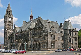
The Metropolitan Borough of Oldham is a metropolitan borough of Greater Manchester in North West England. It is named after its largest town, Oldham, The borough had a population of 237,628 making it the seventh-largest district by population in Greater Manchester. The borough spans 55 square miles (142 km2).

Oldham R.L.F.C., also known as the Roughyeds, is a professional rugby league football club in Oldham, Greater Manchester, England. The club currently competes in the RFL League 1, the third tier of British Rugby League.

Boundary Park is a football stadium in Oldham, Greater Manchester, England. Its name originates from the fact that it lies at the northwestern extremity of Oldham, with Royton and Chadderton lying immediately north and west respectively.

Shaw and Crompton is a civil parish in the Metropolitan Borough of Oldham, Greater Manchester, England, which contains the town of Shaw and lies on the River Beal at the foothills of the South Pennines. It is located 2.3 miles (3.7 km) north of Oldham, 3.6 miles (5.8 km) south-east of Rochdale and 8.7 miles (14 km) north-east of Manchester.
Tameside Metropolitan Borough Council elections are generally held three years out of every four, with a third of the council being elected each time. Tameside Metropolitan Borough Council is the local authority for the metropolitan borough of Tameside in Greater Manchester, England. Since the last boundary changes in 2004, 57 councillors have been elected from 19 wards. New ward boundaries have been prepared to take effect from the 2023 election.
Oldham Metropolitan Borough Council elections are generally held three years out of every four, with a third of the council being elected each time. Oldham Metropolitan Borough Council, generally known as Oldham Council, is the local authority for the metropolitan borough of Oldham in Greater Manchester, England. Since the last boundary changes in 2004, 60 councillors have been elected from 20 wards. New ward boundaries are due to come into effect from the 2023 election.
The 1999 Oldham Borough Council election took place on 6 May 1999 to elect members of Oldham Metropolitan Borough Council in Greater Manchester, England. One third of the council was up for election and the Labour Party stayed in overall control of the council.
The 2000 Oldham Borough Council election took place on 4 May 2000 to elect members of Oldham Metropolitan Borough Council in Greater Manchester, England. One third of the council was up for election and the Liberal Democrats gained overall control of the council from the Labour Party.
The 2012 Oldham Council election took place on 3 May 2012 to elect members of Oldham Metropolitan Borough Council in the North West, England. This was on the same day as other 2012 United Kingdom local elections.

Oldham Metropolitan Borough Council, branded and commonly referred to as Oldham Council, is the local authority of the Metropolitan Borough of Oldham in Greater Manchester, England. It is a metropolitan district council, one of ten in Greater Manchester and one of 36 in the metropolitan counties of England, and provides the majority of local government services in Oldham. It is composed of 60 councillors, three for each of the 20 electoral wards of the borough.

James Ignatius O'Rourke McMahon is a British politician serving as Shadow Secretary of State for Environment, Food and Rural Affairs since 2021. He has been the Member of Parliament (MP) for Oldham West and Royton since 2015 under the Labour and Co-operative banner.

Moston Brook is a stream in Greater Manchester in north-west England and a tributary of the River Irk. The brook is formed at the confluence of Bower Brook and Hole Bottom Brook. This occurs near the Rochdale Canal in Failsworth in the Metropolitan Borough of Oldham. It flows southwest, forming the border between Moston, Manchester and Failsworth before being culverted almost all of the remaining route to its meeting the River Irk. It has a total length of about 3.7 miles.
The 2022 Oldham Metropolitan Borough Council election took place on 5 May 2022. One third—20 out of 60—of councillors on Oldham Council was elected. The election took place alongside other local elections across the United Kingdom.
