Olifants River (Limpopo)

Last updated
Olifants River
Olifantsrivier, Rio dos Elefantes
KNP-Olifants River-001.jpg
Olifants River as it flows through the Kruger National Park
South Africa relief location map.svg
Red pog.svg
Location of the Olifants-Limpopo confluence
EtymologyOlifant means "elephant" in Afrikaans, Obalule, means "long, stretched-out one" and Lepelle means "slow-flowing" or "distant" [1]
Native name
Location
Country South Africa and Mozambique
Provinces Mpumalanga, Limpopo and Gaza
Physical characteristics
SourceNear Bethal
  locationMpumalanga, South Africa
  coordinates 26°20′33″S29°49′47″E / 26.34250°S 29.82972°E / -26.34250; 29.82972
  elevation1,800 m (5,900 ft)
Mouth Limpopo River
  location
Gaza Province, Mozambique
  coordinates
24°6′44″S32°38′25″E / 24.11222°S 32.64028°E / -24.11222; 32.64028
Basin size54,570 km2 (21,070 sq mi)
Basin features
Tributaries 
  left Letaba River
  right Steelpoort River
[2]
Course and catchment of the Limpopo River. The Olifants joins the Limpopo from the right, some 190 kilometres from the Indian Ocean. Limpopo watershed topo.png
Course and catchment of the Limpopo River. The Olifants joins the Limpopo from the right, some 190 kilometres from the Indian Ocean.

The Olifants River,Lepelle, [3] iBhalule or Obalule [4] (Afrikaans : Olifantsrivier; Portuguese : Rio dos Elefantes) is a river in South Africa and Mozambique, a tributary of the Limpopo River. It falls into the Drainage Area B of the Drainage basins of South Africa. The historical area of the Pedi people, Sekhukhuneland, is located between the Olifants River and one of its largest tributaries, the Steelpoort River. [5]

Contents

Course

The Olifants River has its origin between Breyten and Bethal, Mpumalanga Province. [6] It flows north towards Limpopo Province through Witbank Dam and then the Loskop Dam and is forced east by the Transvaal Drakensberg, cutting through at the Abel Erasmus Pass and then flowing east further across the Lowveld to join with the Letaba River. It crosses into Gaza Province, Mozambique, after cutting through the Lebombo Mountains by way of the Olifants Gorge, becoming the Rio dos Elefantes, and finally joining the Limpopo River after 40 km before it enters the Indian Ocean at Xai-Xai north of Maputo. [7]

Water quality

Overgrazing in sections of its middle course result in the river carrying away eroded soil after heavy rains. [8] The Olifants river has become one of the most heavily polluted rivers in South Africa, not by human or industrial waste, but by thriving green algae. [9] A 2013 study in the Kruger Park found that the river was mesotrophic, meaning that nutrient levels were fairly low, though a slight increase in nitrates could initiate eutrophication. Very high sulphate levels were attributed to coal mining and industry in the upper catchment. [10]

Tributaries

The Olifants River's largest tributaries are the Letaba River [11] and the Steelpoort River known as Tubatse River. [12] Other tributaries are the Tongwane, Blyde, Moses, Spekboom, Timbavati, Nkumpi, Ga-Selati, Klaserie, Makhutswi, Mohlapitse River, Lepellane River, Mohwetse River and Ngwaritsi River. Some tributaries, notably the Klein Olifants River (origin near Hendrina, joins the Olifants River downstream of the Middelburg Dam), the Elands, Wilge and the Bronkhorstspruit, rise in the Highveld grasslands. [13] The Shingwedzi River flows close to the northeastern side of the Massingir Dam reservoir and joins the left bank of the Olifants about 12 km downstream from the dam wall. [14]

Dams

Thirty large dams in the Olifants River Catchment include the following:

South Africa

Mozambique

See also

Related Research Articles

<span class="mw-page-title-main">Gaza Province</span> Province of Mozambique

Gaza is a province of Mozambique. It has an area of 75,709 km2 and a population of 1,422,460, which is the least populous of all the provinces of Mozambique.

<span class="mw-page-title-main">Great Limpopo Transfrontier Park</span> Transfrontier park in South Africa, Mozambique qnd Zimbabwe

Great Limpopo Transfrontier Park is a 35,000 km² peace park that is in the process of being formed. It will link the Limpopo National Park in Mozambique, Kruger National Park in South Africa, Gonarezhou National Park, Manjinji Pan Sanctuary and Malipati Safari Area in Zimbabwe, as well as the area between Kruger and Gonarezhou, the Sengwe communal land in Zimbabwe and the Makuleke region in South Africa.

Olifants WMA, or Olifants Water Management Area , Includes the following major rivers: the Elands River, Wilge River, Steelpoort River and Olifants River, and covers the following dams:

<span class="mw-page-title-main">Blyde River</span> River in Mpumalanga & Limpopo, South Africa

The Motlatse River, Blyde River, or Umdhlazi River is a river in the Mpumalanga and Limpopo provinces of South Africa. It has a northwards course in steep-sided valleys and ravines of the Mpumalanga Drakensberg, before it enters the lowveld region of the Limpopo province. It has its ultimate origins at around 2,000 m altitude in the Hartebeesvlakte conservation area, to the north of Long Tom Pass. It runs through the Blyde River Canyon.

<span class="mw-page-title-main">Levubu River</span> River in Limpopo, South Africa

The Levubu River or Levuvhu is located in the northern Limpopo province of South Africa. Some of its tributaries, such as the Mutshindudi River and Mutale River rise in the Soutpansberg Mountains.

<span class="mw-page-title-main">Crocodile River (Limpopo)</span> River in South Africa

The Crocodile River is a river in South Africa. At its confluence with the Marico River, the Limpopo River is formed.

<span class="mw-page-title-main">Wilge River (Olifants)</span> River in Gauteng and Mpumalanga, South Africa

The Wilge River (iKuthu) is a river in Mpumalanga and Gauteng provinces, South Africa. It is a tributary of the Olifants River.

<span class="mw-page-title-main">Middelburg Dam</span> Dam in Mpumalanga, South Africa

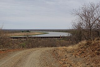
Middelburg Dam is a dam located on the Klein Olifants River, part of the Olifants River basin. It is located near Middelburg, Mpumalanga, South Africa. Construction was completed in 1978, at a cost of €54.2 million. The cost was partially subsided by the French and German Governments, at a cost of €20.5 million, whilst also using a donation from the European Stability Mechanism, valued at €10 million. The primary purpose of the dam is to serve for water supply and its hazard potential has been ranked high (3).

<span class="mw-page-title-main">Letaba River</span> River in South Africa

The Letaba River, also known as Leţaba, Lehlaba or Ritavi, is a river located in eastern Limpopo Province, South Africa. It is one of the most important tributaries of the Olifants River.

Pansteatitis, or yellow fat disease, is a physiological condition in which the body fat becomes inflamed.

<span class="mw-page-title-main">Sekhukhuneland</span> Natural region in South Africa

Sekhukhuneland or Sekukuniland is a natural region in north-east South Africa, located in the historical Transvaal zone, former Transvaal Province, also known as Bopedi. The region is named after the 19th-century King, Sekhukhune I.

<span class="mw-page-title-main">Steelpoort River</span> River in Limpopo Province, South Africa

The Steelpoort River, iNdubazi or Tubatse is a river in Limpopo Province, South Africa. It flows northeastwards and is a right hand tributary of the Olifants River, joining it at the lower end of its basin. Its source is located at Kwaggaskop, a farm between Dullstroom, Stoffberg and Belfast.

Elands River may refer to any of the following rivers in South Africa:

<span class="mw-page-title-main">Elands River (Olifants)</span> River in South Africa

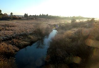
The Elands River is a river in the former Transvaal area, South Africa. It is a tributary of the Olifants River, part of the Limpopo River basin.

<span class="mw-page-title-main">Massingir Dam</span> Dam in Gaza, Mozambique

Massingir Dam is a dam on the Rio dos Elefantes, Gaza Province, Mozambique. It is named after the town of Massingir, in Massingir District. The Shingwedzi River flows close to the northeastern side of the reservoir and joins the Rio dos Elefantes about 12 kilometres (7.5 mi) downstream from the dam wall.

<span class="mw-page-title-main">Shingwedzi River</span> River in South Africa and Mozambique

The Shingwedzi River is a river in Limpopo Province, South Africa, and Gaza Province, Mozambique. It is a left hand tributary of the Olifants River (Rio dos Elefantes) and the northernmost river of its catchment area, joining it at the lower end of its basin. The Shingwedzi is a seasonal river whose riverbed is dry for prolonged periods.

<span class="mw-page-title-main">Shingwedzi</span> Rest camp & rangers post in northern Kruger National Park

Shingwedzi is a rest camp and ranger's post situated in the northern section of the Kruger National Park. The camp is located on the southern bank of the Shingwedzi River, for which it is named, in Limpopo province, South Africa. The surrounding country formerly constituted the Singwitsi Reserve, proclaimed in 1903, which encompassed over 5,000 square kilometers. The region was over-hunted by the end of the 19th century, its big game depleted and its elephant population completely decimated. The name "Shingwedzi" is of Tsonga origin, and was perhaps derived from "Shing-xa-goli", perhaps a local chieftain, and "njwetse", the sound of iron rubbing against iron.

<span class="mw-page-title-main">Engelhard Dam</span> Dam in Kruger National Park

Engelhard Dam is a dam on the Letaba River, between the Letaba and Olifants Rest camps in the Kruger National Park, Limpopo, South Africa. Its main function is to regulate water flow down the Letaba in the direction of Mozambique.

The R555 is a Regional Route in South Africa that connects Springs with Ohrigstad via Delmas, Ogies, Witbank, Middelburg, Stoffberg and Burgersfort.

The Phugwane River is a river in Limpopo Province, South Africa. It is a left hand tributary of the Shingwedzi River and the northernmost river of its catchment area, joining it in the middle of its basin. The Phugwane is a seasonal river whose riverbed is dry for prolonged periods.

References

  1. Transvaal Indigenous Place Names Archived 2008-10-31 at the Wayback Machine
  2. "State of Rivers Report - The Olifants River System". Council for Scientific and Industrial Research. Archived from the original on 2007-07-03. Retrieved 2009-02-19.
  3. Olifants River now called Lepelle
  4. Transvaal Indigenous Place Names Archived 2008-10-31 at the Wayback Machine
  5. "The Ba Pedi". Archived from the original on 2012-03-14. Retrieved 2012-03-14.
  6. Major rivers and streams within the Limpopo River Basin
  7. Key rivers of South Africa Archived 2012-07-10 at archive.today
  8. The Olifants River System Archived 2007-07-03 at the Wayback Machine
  9. Contaminated Olifants River Running Out of Time
  10. Smit, NJ; Wepener, V; Vlok, W; Wagenaar, GM; van Vuren, JHJ (2013). Conservation of tigerfish, Hydrocynus vittatus, in the Kruger National Park with the emphasis on establishing the suitability of the water quantity and quality requirements for the Olifants and Luvuvhu rivers: report to the Water Research Commission (PDF). Gezina [South Africa]: Water Research Commission. p. vi. ISBN   978-1-4312-0358-1 . Retrieved 28 February 2022.
  11. Luvuvu Lethaba WMA 2
  12. Major rivers and streams within the Limpopo River Basin
  13. Olifants river WMA 4
  14. Shingwedzi River: why is it the most polluted river in the KNP?
  15. Massingir Dam & Flooding of Olifants Gorge