
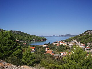
Lopud is a small island off the coast of Dalmatia, southern Croatia. Lopud is economically the most developed of the Elaphiti Islands, and can be reached by boat from Dubrovnik, Trsteno, Orašac and Zaton. The island is famous for its sandy beaches, in particular the bay of Šunj. Lopud is the second largest island of the Elaphiti islands, between Koločep and Šipan. It is famous as the "island in the middle". It has an area of 4.63 square kilometres and its highest point is Polačica, 216 metres above sea level. It has 11.5 km (7 mi) of coastline, of which 1.2 km (1 mi) is sandy.

Dugi Otok is the seventh largest island in the Adriatic Sea, part of Croatia. It is located off the Dalmatian coast, west of Zadar. It is the largest and westernmost of the Zadarian Islands, and derives its name from its distinctive shape: it is 44.5 km long by 4.8 km wide, with an area of 114 square kilometres (44 sq mi). Its elevation reaches 300 m; and many of its higher portions contain stands of Maritime Pine.

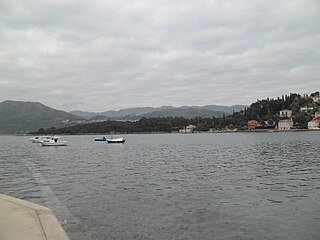
The Elaphiti Islands or the Elaphites is a small archipelago consisting of several islands stretching northwest of Dubrovnik, in the Adriatic Sea. The Elaphites have a total land area of around 30 square kilometres and a population of 850 inhabitants. The islands are covered with characteristic Mediterranean evergreen vegetation and attract large numbers of tourists during the summer tourist season due to their beaches and pristine scenery.
The island of Koločep is one of the three inhabited Elaphiti Islands situated near the city of Dubrovnik with an area of 2.44 square kilometres. Koločep is the southernmost inhabited island in Croatia. In the 2011 census, the population of the island was 163.
Rivanj is an Adriatic Sea island in the Zadar Archipelago, between the islands of Sestrunj and Ugljan, with an area of 4.4 square kilometres (1.7 sq mi) ; population 31 (2011); highest peak Lukocina. The only village is Rivanj, located in the interior of the island; below it, on the south-western coast, is a small harbour with a hamlet. The island is largely covered with underbrush and thicket. Rivanj has a daily ferry and ship line with Zadar. The present village was allegedly founded by the inhabitants of the island of Ugljan. Rivanj is frequented by boaters.
Vrgada is an island off the coast of Croatia in the Adriatic Sea. It is located halfway between Zadar and Šibenik, in the archipelago northwest of Murter and south of Biograd na moru, 2.5 nautical miles (4.6 km) from the mainland. It has area of 3.7 square kilometres. and population of 249. The only settlement on the island is also named Vrgada and is surrounded with pine forest. Main industries are agriculture and fishing. On northeast coast, there are several small coves.

Drvenik Veli is an island in Croatian part of Adriatic Sea. It is situated in the middle of the Dalmatian archipelago, northwest of Šolta, 1.8 kilometres from the mainland. Its area is 12.07 square kilometres (4.66 sq mi). The highest peak is 178 metres high. The only settlement on the island is the near-eponymous village of Drvenik Veliki with a population of 150.

Rava is an island in the Croatian part of the Adriatic Sea. It is situated in the Zadar Archipelago, between Iž and Dugi Otok, 16 nautical miles (30 km) from Zadar. Its area is 3.6 km2, and it has a population of 117. The only settlements on the island are Vela Rava and Mala Rava. The coast of the island is very indented with 13 bays and 15.45 kilometres of coastline. The island is composed of dolomite. The primary industries are agriculture and fishing.

Drvenik Mali (also called Ploča by local population; is an island in Croatian part of Adriatic Sea. It is situated in middle-Dalmatian archipelago, west of Drvenik Veliki, 8 nautical miles from Trogir. Its area is 3.43 square kilometres. The only settlement on the island is the eponymous village with a population of 87. The coast is well indented and sea around the island is shallow, thus convenient for fishing. The highest peak is 79 metres high. Main industries are agriculture, fishing and tourism.

Sestrunj is an island in the Croatian part of the Adriatic Sea. It is situated in Zadar Archipelago, between Ugljan, Rivanj and Dugi Otok. Its area is 15.1 square kilometres, and it has population of 48. The only settlement is also called Sestrunj and is located in the island's interior. The island is partially covered with maquis shrubland and low forests. Remains of an Illyrian fort are situated on the island. The island's main industries are agriculture and fishing.

Sveti Andrija is an island in the Croatian part of the Adriatic Sea. It is part of the Elaphiti Islands archipelago, Dalmatia and is situated 6 nautical miles (11 km) from Dubrovnik, 3 nautical miles (6 km) from Koločep, 2 nautical miles (4 km) from Lopud and 4 nautical miles (7 km) from Šipan. The island is 475 metres long, and its maximal width is 130 metres, while its coastline is 1,130 m (3,710 ft) long. The total area of the island is 53,757 square metres, with a maximum height elevation of 57 m (187 ft) above sea level.
Kornat is an island in the Croatian part of the Adriatic Sea, in central Dalmatia. With an area of 32.44 km2 it is the 16th largest island in Croatia and the largest island in the eponymous Kornati islands archipelago. It is part of the Kornati National Park, which is composed of a total of 89 islands, islets and rocks.

Žut is an uninhabited island in the Croatian part of the Adriatic Sea, in central Dalmatia. With an area of 14.83 km2 (5.73 sq mi) it is the 28th largest island in Croatia and the second largest island in the Kornati archipelago, after Kornat. Although most of the archipelago, composed of 89 islands, islets and rocks, is included in the Kornati National Park, the island of Žut is not.

Prvić is an uninhabited island in the Croatian part of the Adriatic Sea, located in the Kvarner Gulf. It is the largest of the so-called Senj Islands, a group of small islands and islets located off the coast of the mainland city of Senj, lying between the larger islands of Krk and Rab. Other significant islands in the Senj group are Sveti Grgur and Goli Otok, along with a number of islets and rocks, which are all uninhabited. Prvić has an area is 12.76 square kilometres (4.93 sq mi), which makes it the largest uninhabited Croatian island and 30th largest overall.

Plavnik is an unpopulated island in the Adriatic Sea, belonging to Croatia located between the Central Straits and the Kvarner Bay. The Krusija Channel cuts it off from the eastern coast of the island of Cres. This channel is the shortest route from the Adriatic Sea through the islands to Rijeka. A lighthouse, established in 1890, sits at the northwestern point of the islet, marking the east side of the narrowest opening of the Krusija Channel.
Sit is an uninhabited Croatian island in the Adriatic Sea located between Žut and Pašman. Its area is 1.77 km2 (0.68 sq mi).

Smokvica Vela is an uninhabited Croatian island in the Adriatic Sea located southeast of Kornat. Its area is 1.05 km2 (0.41 sq mi). Lojena Bay is located on the southeast part of the island, exposed to the jugo wind and sheltered from other winds. The northern tip of the island is marked by a lighthouse.

Stražica Lighthouse on the island of Prvić in the Adriatic Sea was built in 1875 and consists of a small stone house and a 5-metre (16 ft) tall lighthouse tower. A crew of lightkeepers were stationed on the island until it was made fully automated in 1974. In 1993 the natural gas-powered system was replaced with solar panels and is today remotely controlled by Plovput, the state-owned company for maritime traffic which controls the entire network of Croatian lighthouses. Until 1974, the lighthouse crew were the only inhabitants of Prvić, and until the early 2000s it was believed that Prvić held the distinction of being the largest uninhabited Croatian island, but this was refuted when new measurements published in 2004 showed that the island of Žut is bigger by some 2 square kilometres (0.77 sq mi).
Jerolim is a Croatian island in the Adriatic Sea, one of the Paklinski Islands southwest of Hvar.

