
Maidencreek Township is a township in Berks County, Pennsylvania. The population was 9,126 at the 2010 census.

Northampton Township is a township in Bucks County, Pennsylvania. The township is located approximately 12 miles northeast of Philadelphia. The population was 39,726 at the 2010 census.
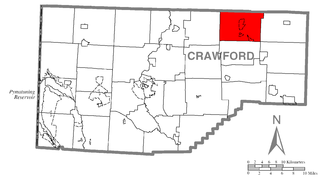
Bloomfield Township is a township in Crawford County, Pennsylvania, United States. The population was 1,867 at the 2020 census.
Lower Salford is a township in Montgomery County, Pennsylvania. It is located one mile west of the Lansdale exit of the Pennsylvania Turnpike. It is centered on the intersection of Route 63, and Route 113.

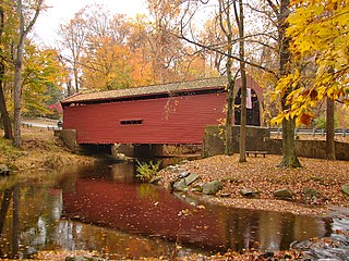
Brandywine Creek is a tributary of the Christina River in southeastern Pennsylvania and northern Delaware in the United States. The Lower Brandywine is 20.4 miles (32.8 km) long and is a designated Pennsylvania Scenic River with several tributary streams. The East Branch and West Branch of the creek originate within 2 miles (3 km) of each other on the slopes of Welsh Mountain in Honey Brook Township, Pennsylvania, about 20 miles (32 km) northwest of their confluence.
Holland is an unincorporated community in Northampton Township, Bucks County, Pennsylvania, United States. It is located next to Newtown, Richboro, and Churchville. One of its communities is Village Shires, which has approximately 4,000 residents.
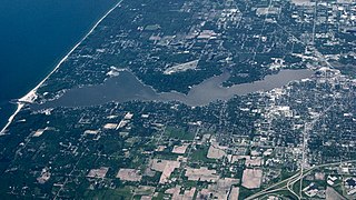
Lake Macatawa is a lake in Ottawa County in the U.S. state of Michigan.
Ridgefield Township was a township that existed in Bergen County, New Jersey. The township was created in 1871, when Hackensack Township was trisected to form Palisades Township in the northernmost third, Englewood Township in the central strip and Ridgefield Township encompassing the southernmost portion, stretching from the Hudson River on the east to the Hackensack River, with Hudson County to the south. Much of the area had been during the colonial area known as the English Neighborhood. As described in the 1882 book, History of Bergen and Passaic counties, New Jersey,
Ridgefield is the first township in Bergen County which the traveler enters in passing up the Palisades. His first impressions are much like those of old Hendrick Hudson in speaking of a wider extent of country: "A very good land to fall in with, and a pleasant land to see." The valley of the Hackensack invited early settlers in the seventeenth century, and the valley of the Overpeck Creek, a navigable arm of the Hackensack, also attracted settlers quite as early in this direction. Sloops and schooners can pass up this creek nearly to the northern boundary of the township. Ridgefield is bounded on the north by Englewood, on the east by the Hudson, on the south by Hudson County, and on the west by the Hackensack River. The southern boundary is less than two miles in extent, and the northern less than four, and the length of the township from north to south does not exceed four miles. Bellman's Creek, forming part of the southern boundary, the Hackensack, the Overpeck, the Hudson, with more than a dozen other smaller streams and rivulets, bountifully supply the whole township with water. From the western border of the Palisades the land descends to the Overpeck, forming a most beautiful valley, with the land again rising to a high ridge midway between the Overpeck and the Hackensack. From this long ridge, extending far to the north beyond this township, it took its name of Ridgefield.
The New York, Susquehanna and Western, formerly the Midland Railroad, the Jersey City and Albany Railroad, and the Northern Railway of New Jersey—all running northward through the township— afford ample railroad accommodations. The Susquehanna enters the township at Bellman's Creek, and the Northern at about one hundred feet south of the creek, and at a point north and east of the Susquehanna. The Albany road in this locality is not yet constructed, diverging at present from the track of the Susquehanna between Little Ferry and Bogota stations. It has, however, an independent line projected and now under construction to New York City.
Early Settlements. Ridgefield embraces the earliest settlements in the ancient township of Hackensack, antedating even the organization of that township in 1693, and of the county of Bergen in 1675. There seems to have been no town or village compactly built, like the village of Bergen, but there were settlements both of Dutch and English in and about what was subsequently known as English Neighborhood prior to 1675. The Westervelts, the Zimcrmans, the Bantas, and the Blauvelts, all coming from Holland, settled in the middle of the seventeenth century in that locality. The ancestors of Jacob P. Westervelt, now of Hackensack Village, with himself, were born in English Neighborhood. His father was born there in 1776, and was the son of Christopher Westervelt, who was born there certainly as early as 1690, and he was the son of the original ancestor of this family, who came from Holland and settled on Overpeck Creek, within the present limits of Ridgefield township, probably about 1670.
Northern Liberties Township is a defunct township that was located in Philadelphia County, Pennsylvania, United States. The township ceased to exist and was incorporated into the City of Philadelphia after the passage of the Act of Consolidation, 1854.
Crum Creek is a creek in Delaware County and Chester County, Pennsylvania, flowing approximately 24 miles (39 km), generally in a southward direction and draining into the Delaware River in Eddystone, Pennsylvania. It begins in a swamp near Newtown Square, Pennsylvania along which several mills were established in the 19th century. Right afterward it crosses under Pennsylvania Route 29 and winds one and a half miles (2.4 km) downstream until it hits the hamlet of Crum Creek. It later flows into the Delaware River near Philadelphia.

Omnia is a self-described "neoceltic pagan folk" band based in the Netherlands, whose members over the years have had Irish, Dutch, Cornish, Belgian, Indonesian, and Persian backgrounds. Their music takes the form of various cultural routes, from places such as Ireland, England, Cornwall, and Iran. The name of the band is a Latin word that means "everything".

Pennsylvania Route 23 is an 81.14-mile-long (130.58 km) state highway in southeastern Pennsylvania. The route begins at PA 441 in Marietta and heads east to U.S. Route 1 at City Avenue on the border of Lower Merion Township and Philadelphia. PA 23 begins at Marietta in Lancaster County and continues east to Lancaster, where it passes through the city on a one-way pair of streets and intersects US 222 and US 30.

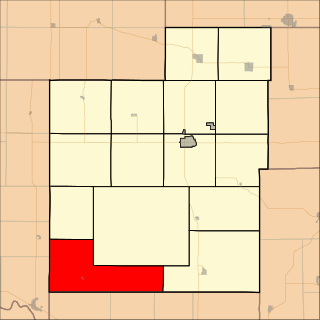
Fairview Township is a township in Cowley County, Kansas, USA. As of the 2000 census, its population was 203.

Grant Township is a township in Dickinson County, Kansas, USA. As of the 2000 census, its population was 918.

Wheatland Township is a township in Dickinson County, Kansas, USA. As of the 2000 census, its population was 152.

Pottawatomie Township is a township in Franklin County, Kansas, USA. As of the 2000 census, its population was 669.
Washington Township is a township in Jackson County, Kansas, USA. As of the 2000 census, its population was 516.

Dreahook is an unincorporated community in Readington Township in Hunterdon County, in the U.S. state of New Jersey at the intersection of CR-620/Dreahook Rd and CR 523. The name is a corruption of Driehoek, which is the Dutch word for triangle. It was likely named for the triangle created by the settlement in its relation to the early roads to Flemington, Whitehouse Station, Readington Village and Pleasant Run, which have since been rerouted. Dreahook Creek and Holland Brook both pass through the area of the former village. Dreahook village once had blacksmith shop, a school and a store. Settlers farmed the land here because of the rich soil along the base of Cushetunk Mountain. There are still numerous farms in the area, including the Readington River Buffalo Farm between Dreahook and Stanton.
Dutch Creek Township is a township in Washington County, Iowa, USA.

