
The South Platte River is one of the two principal tributaries of the Platte River. Flowing through the U.S. states of Colorado and Nebraska, it is itself a major river of the American Midwest and the American Southwest/Mountain West. Its drainage basin includes much of the eastern flank of the Rocky Mountains in Colorado, much of the populated region known as the Colorado Front Range and Eastern Plains, and a portion of southeastern Wyoming in the vicinity of the city of Cheyenne. It joins the North Platte River in western Nebraska to form the Platte, which then flows across Nebraska to the Missouri. The river serves as the principal source of water for eastern Colorado. In its valley along the foothills in Colorado, it has permitted agriculture in an area of the Colorado Piedmont and Great Plains that is otherwise arid.

North Platte is a city in and the county seat of Lincoln County, Nebraska, United States. It is located in the west-central part of the state, along Interstate 80, at the confluence of the North and South Platte Rivers forming the Platte River. The population was 23,390 at the 2020 census.

Platte County is a county located in the U.S. state of Nebraska. As of the 2010 United States Census, the population was 32,237. Its county seat is Columbus. The county was created in 1855.

Lincoln County is a county located in the U.S. state of Nebraska. As of the 2020 census, the population was 34,676. Its county seat is North Platte. Despite the county's name, the state capital city of Lincoln is not in or near Lincoln County. The city of Lincoln is, instead, located more than 200 miles further to the east in Lancaster County.

Scouting in Nebraska has a long history, from the 1910s to the present day, serving thousands of youth in programs that suit the environment in which they live.

Columbus is a city in and the county seat of Platte County, in the state of Nebraska in the Midwestern United States. The population was 24,028 at the 2020 census, making it the 10th largest city in Nebraska.

The Platte River is a major river in the State of Nebraska. It is about 310 mi (500 km) long; measured to its farthest source via its tributary, the North Platte River, it flows for over 1,050 miles (1,690 km). The Platte River is a tributary of the Missouri River, which itself is a tributary of the Mississippi River which flows to the Gulf of Mexico. The Platte over most of its length is a broad, shallow, meandering stream with a sandy bottom and many islands—a braided stream.
Albert Bierstadt was a German-American painter best known for his lavish, sweeping landscapes of the American West. He joined several journeys of the Westward Expansion to paint the scenes. He was not the first artist to record the sites, but he was the foremost painter of them for the remainder of the 19th century.

The North Platte River is a major tributary of the Platte River and is approximately 716 miles (1,152 km) long, counting its many curves. In a straight line, it travels about 550 miles (890 km), along its course through the U.S. states of Colorado, Wyoming, and Nebraska.

The Loup River is a tributary of the Platte River, approximately 68 miles (109 km) long, in central Nebraska in the United States. The river drains a sparsely populated rural agricultural area on the eastern edge of the Great Plains southeast of the Sandhills. The name of the river means "wolf" in French, named by early French trappers after the Skidi band of the Pawnee, whose name means "Wolf People," and who lived along its banks. The river and its tributaries, including the North Loup, Middle Loup, and South Loup, are known colloquially as "the Loups", comprising over 1800 mi (2900 km) of streams and draining approximately one-fifth of Nebraska.
The Nebraska Department of Transportation (NDOT) is the state government agency charged with building and maintaining the state highways in the U.S. state of Nebraska, as well as the state's airports. The main headquarters of the agency is located in Lincoln, the capital city. There are currently eight NDOT district offices located across the state.

Nebraska Highway 92 is a highway that enters the state from Nebraska's western border at the Wyoming state line west of Lyman, Nebraska, to the state's eastern border on the South Omaha Veterans Memorial Bridge over the Missouri River in Omaha, where it enters Iowa. Nebraska Highway 92 passes, follows, or runs through a number of the state's principal attractions, including Scotts Bluff National Monument, the Oregon Trail, Chimney Rock National Historic Site, Ash Hollow State Historical Park, Lake McConaughy, the Nebraska Sand Hills, and the City of Omaha. Nebraska Highway 92 is the longest state route in the state at a total of 489.1 miles (787.1 km), and is part of a continuous 886-mile (1,426 km) four-state "Highway 92" which begins in Torrington, Wyoming, goes through Nebraska and Iowa and ends in La Moille, Illinois. It is the only Nebraska Highway to run from the west border to the east border of Nebraska; along the way it crosses the Platte River or its tributary North Platte River a total of five times.

Platte River State Park is a public recreation area encompassing 453 acres (183 ha) on the southern bluffs of the Platte River two miles (3.2 km) west of Louisville, Nebraska. The state park has a relatively steep, rolling topography compared to the surrounding region, with much of it forested.

U.S. Highway 26 (US‑26) is an east–west highway in western Nebraska. It enters the state from Wyoming just west of Henry. The eastern terminus of US‑26 is in Ogallala at an interchange with Interstate 80 (I-80). The highway largely parallels the North Platte River for the majority of its route in Nebraska and as such, runs at a northwest-southeast angle. The highway also parallels the original paths of the Oregon Trail, the California Trail and the Mormon Pioneer Trail.

Lake McConaughy is a reservoir on the North Platte River. It is located 9 miles (14 km) north of Ogallala, Nebraska, United States, near U.S. Highway 26 and Nebraska Highway 61. The reservoir was named for Charles W. McConaughy, a grain merchant and mayor of Holdrege, Nebraska, one of the leading promoters of the project. Although he did not live to see the completion of the project, his leadership and perseverance eventually culminated in a public power and irrigation project that helped Nebraska become one of the nation's leading agricultural states.

The Great Platte River Road was a major overland travel corridor approximately following the course of the Platte River in present-day Nebraska and Wyoming that was shared by several popular emigrant trails during the 19th century, including the Trapper's Trail, the Oregon Trail, the Mormon Trail, the California Trail, the Pony Express route, and the military road connecting Fort Leavenworth and Fort Laramie. The road, which extended nearly 370 miles (600 km) from the Second Fort Kearny to Fort Laramie, was utilized primarily from 1841 to 1866. In modern times it is often regarded as a sort of superhighway of its era, and has been referred to as "the grand corridor of America's westward expansion".

The Rocky Mountains, Lander's Peak is an 1863 landscape oil painting by the German-American painter Albert Bierstadt. It is based on sketches made during Bierstadt's travels with Frederick W. Lander's Honey Road Survey Party in 1859. The painting shows Lander's Peak in the Wind River Range of the Rocky Mountains, with an encampment of Native Americans in the foreground. It has been compared to, and exhibited with, The Heart of the Andes by Frederic Edwin Church. Lander's Peak immediately became a critical and popular success and sold in 1865 for $25,000.
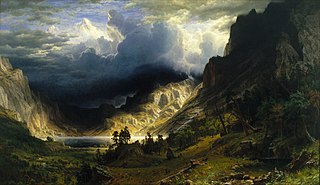
A Storm in the Rocky Mountains, Mt. Rosalie is an 1866 landscape oil painting by German-American painter Albert Bierstadt (1830-1902) which was inspired by sketches created on an 1863 expedition.
