Related Research Articles

A swamp is a forested wetland. Swamps are considered to be transition zones because both land and water play a role in creating this environment. Swamps vary in size and are located all around the world. The water of a swamp may be fresh water, brackish water, or seawater. Freshwater swamps form along large rivers or lakes where they are critically dependent upon rainwater and seasonal flooding to maintain natural water level fluctuations. Saltwater swamps are found along tropical and subtropical coastlines. Some swamps have hammocks, or dry-land protrusions, covered by aquatic vegetation, or vegetation that tolerates periodic inundation or soil saturation. The two main types of swamp are "true" or swamp forests and "transitional" or shrub swamps. In the boreal regions of Canada, the word swamp is colloquially used for what is more formally termed a bog, fen, or muskeg. Some of the world's largest swamps are found along major rivers such as the Amazon, the Mississippi, and the Congo.

Peat is an accumulation of partially decayed vegetation or organic matter. It is unique to natural areas called peatlands, bogs, mires, moors, or muskegs. Sphagnum moss, also called peat moss, is one of the most common components in peat, although many other plants can contribute. The biological features of sphagnum mosses act to create a habitat aiding peat formation, a phenomenon termed 'habitat manipulation'. Soils consisting primarily of peat are known as histosols. Peat forms in wetland conditions, where flooding or stagnant water obstructs the flow of oxygen from the atmosphere, slowing the rate of decomposition. Peat properties such as organic matter content and saturated hydraulic conductivity can exhibit high spatial heterogeneity.

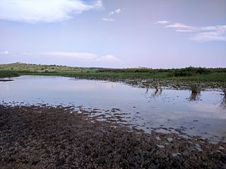
A wetland is a distinct ecosystem that is flooded or saturated by water, either permanently for years or decades or seasonally for a shorter periods. Flooding results in oxygen-free anoxic processes prevailing, especially in the soils. The primary factor that distinguishes wetlands from terrestrial land forms or water bodies is the characteristic vegetation of aquatic plants, adapted to the unique anoxic hydric soils. Wetlands are considered among the most biologically diverse of all ecosystems, serving as home to a wide range of plant and animal species. Methods for assessing wetland functions, wetland ecological health, and general wetland condition have been developed for many regions of the world. These methods have contributed to wetland conservation partly by raising public awareness of the functions some wetlands provide. Constructed wetlands are designed and built to treat municipal and industrial wastewater as well as to divert stormwater runoff. Constructed wetlands may also play a role in water-sensitive urban design.

A fen is a type of peat-accumulating wetland fed by mineral-rich ground or surface water. It is one of the main types of wetlands along with marshes, swamps, and bogs. Bogs and fens, both peat-forming ecosystems, are also known as mires. The unique water chemistry of fens is a result of the ground or surface water input. Typically, this input results in higher mineral concentrations and a more basic pH than found in bogs. As peat accumulates in a fen, groundwater input can be reduced or cut off, making the fen ombrotrophic rather than minerotrophic. In this way, fens can become more acidic and transition to bogs over time.

A bog or bogland is a wetland that accumulates peat as a deposit of dead plant materials – often mosses, typically sphagnum moss. It is one of the four main types of wetlands. Other names for bogs include mire, mosses, quagmire, and muskeg; alkaline mires are called fens. A bayhead is another type of bog found in the forest of the Gulf Coast states in the United States. They are often covered in heath or heather shrubs rooted in the sphagnum moss and peat. The gradual accumulation of decayed plant material in a bog functions as a carbon sink.

Chamaecyparis thyoides, a species of Cupressaceae, is native to the Atlantic coast of North America and is found from southern Maine to Georgia and along the Gulf of Mexico coast from Florida to Mississippi. It is one of two species of Chamaecyparis found in North America. C. thyoides resides on the East Coast and C. lawsoniana can be found on the West Coast. There are two geographically isolated subspecies, treated by some botanists as distinct species, by others at just varietal rank: Chamaecyparis thyoides thyoides and Chamaecyparis thyoides henryae (H.L.Li) E.Murray The species grows in forested wetlands where they tend to dominate the canopy. The trees are associated with a wide variety of other wetland species because of their wide north-south range. The remaining populations are now found mostly in remote locations that would be difficult to harvest, so its popularity as a source of lumber has decreased.
The Green Belt Movement (GBM) is an indigenous grassroots organization in Kenya that empowers women through the planting of trees. It is one of the most effective and well-known grassroots organisations addressing the problem of global deforestation. Professor Wangari Maathai established the organization in 1977 under the auspices of the National Council of Women of Kenya (NCWK). GBM's successes in forest conservation, education, and women's economic empowerment have gained the organisation worldwide acclaim. It is also noted for its advocacy of human rights, democratisation of access to public lands, and environmental justice issues such as the role of women's traditional ecological knowledge in addressing environmental degradation and desertification.

Lake Nakuru is one of the Rift Valley lakes, located at an elevation of 1,754 m (5,755 ft) above sea level. It lies to the south of Nakuru, in the rift valley of Kenya and is protected by Lake Nakuru National Park.

The Aberdare Range is a 160 km (99 mi) long mountain range of upland, north of Kenya's capital Nairobi with an average elevation of 3,500 metres (11,480 ft). It straddles the counties of Nyandarua, Nyeri, Muranga, Kiambu and Laikipia. The mountain range is located in west central Kenya, northeast of Naivasha and Gilgil and lies just south of the Equator. The mountain range is called Nyandarua among the Agikuyu people in whose territory this forest and mountain range is located. The name Nyandarua comes from the Kikuyu word rwandarua meaning a drying hide, due to the distinctive fold of its silhouette.

The Nairobi River is a river that flows across Nairobi, the capital city of Kenya. It is the main river of the Nairobi River Basin, with several parallel streams flowing eastward. All of the Nairobi basin rivers join east of Nairobi and meet the Athi River, which eventually flows into the Indian Ocean. The rivers are mostly narrow and highly polluted, though recent efforts to clean the rivers have improved water quality.

Kiambu County is a county in the former Central Province of Kenya. Its capital is Kiambu and its largest town is Thika town. Kiambu County is the second most populous county in Kenya after Nairobi County. Kiambu County borders Nairobi and Kajiado Counties to the South, Machakos to the East, Murang'a to the North and North East, Nyandarua to the North West, and Nakuru to the West. It has a population of 2,417,735.

Kikuyu is a town in Kiambu County, Kenya, which grew from a settlement of colonial missionaries. The town is located about 20 km (12 mi) northwest of central Nairobi. It is about 20 minutes from Nairobi via a number of routes, including a dual carriage road, and has a railway station on the Mombasa – Malaba Railway Line. The town is named after the Kikuyu/Gĩkũyũ people, the major ethnicity that settled in the area. As of 2019, the total population was 323,881.
The Yala Swamp is a wetland region of about 175 square kilometres (68 sq mi) in Western Kenya.

Carska Bara is the largest individual bog in Serbia, in the municipality of Zrenjanin. Along with the neighboring pond of Stari Begej it forms the Special nature reserve "Carska Bara".

Freshwater biology is the scientific biological study of freshwater ecosystems and is a branch of limnology. This field seeks to understand the relationships between living organisms in their physical environment. These physical environments may include rivers, lakes, streams, ponds, lakes, reservoirs, or wetlands. Knowledge from this discipline is also widely used in industrial processes to make use of biological processes involved with sewage treatment and water purification. Water presence and flow is an essential aspect to species distribution and influences when and where species interact in freshwater environments.

Wetland conservation is aimed at protecting and preserving areas of land including marshes, swamps, bogs, and fens that are covered by water seasonally or permanently due to a variety of threats from both natural and anthropogenic hazards. Some examples of these hazards include habitat loss, pollution, and invasive species. Wetland vary widely in their salinity levels, climate zones, and surrounding geography and play a crucial role in maintaining biodiversity, ecosystem services, and support human communities. Wetlands cover at least six percent of the Earth and have become a focal issue for conservation due to the ecosystem services they provide. More than three billion people, around half the world's population, obtain their basic water needs from inland freshwater wetlands. They provide essential habitats for fish and various wildlife species, playing a vital role in purifying polluted waters and mitigating the damaging effects of floods and storms. Furthermore, they offer a diverse range of recreational activities, including fishing, hunting, photography, and wildlife observation.

Karura Forest is an urban forest in Nairobi, the capital of Kenya. The forest was gazetted in 1932 and is managed by the Kenya Forest Service in conjunction with the Friends of Karura Forest Community Forest Association.

The Yala River is a river in western Kenya, a tributary of Lake Victoria. It generally flows fast over a rocky bed through a wide valley before joining the Nzoia River to form the Yala Swamp on the border of Lake Victoria. The land along its course is mostly cultivated or used for grazing, with relatively few remnants of the original forest. Soil erosion is visible throughout the river basin, particularly in the lower parts. Projects are underway to exploit the river for hydroelectricity.
Lake Sare is a lake in western Kenya that lies between the Yala Swamp and Lake Victoria. It has potential as a site for restocking fish species that have become endangered in Lake Victoria, but due to lack of management the lake ecology is steadily degrading.
Tatu City is a 5,000 acres (2,000 ha) special economic zone (SEZ) located 20 kilometres (12 mi) North of Nairobi Central Business District (CBD) in the Ruiru Municipality area of Kiambu County. It sits within the greater Nairobi Metropolitan region and is a flagship project of the Kenya Vision 2030 blueprint.
References
- 1 2 "Friends of Ondiri Wetland Kenya | Home". friendsofondiriwetlands.org. Retrieved 2021-07-27.
- ↑ Obura, Fredrick. "Increased human activities threaten source of Nairobi River - FarmKenya Initiative". Farm Kenya Initiative. Retrieved 2021-07-27.
- ↑ Muchiri, Nancy W. (2012). The impact of human activities on Wetlands: a case study of Ondiri Wetland in Kiambu County, Kenya (Thesis thesis). University of Nairobi, Kenya.
- 1 2 "Saving Kenya's Capital City Water Source, The Ondiri Wetland". Africa Climate Conversations. 19 July 2021. Retrieved 2021-07-27.
- ↑ Mugo, George (25 July 2021). "Ondiri Wetland water levels rises after fencing". The Star. Retrieved 2021-07-27.
- ↑ Koech, Gilbert. "Ondiri Swamp to be gazetted soon, says Nema". The Star. Retrieved 2021-07-27.
- 1 2 "The World Wetlands Day held at Ondiri Swamp". Kenya News. February 3, 2022. Retrieved Aug 26, 2022.
- ↑ Mungai, Naftali. "Why resource rich Ondiri Swamp must be conserved". The Standard. Retrieved 2022-08-26.
- 1 2 May 21, 2020, Thursday (2020-09-19). "Greening Ondiri, the resource-rich Old Lake". Business Daily. Retrieved 2022-08-26.
{{cite web}}: CS1 maint: numeric names: authors list (link) - ↑ Wetland Warrior | 52 Documentary , retrieved 2022-08-26
- ↑ Wetland Warrior | 52 Documentary , retrieved 2022-09-07
- ↑ Mungai, Naftali. "Why resource rich Ondiri Swamp must be conserved". The Standard. Retrieved 2022-09-07.
| | This Kenya related article is a stub. You can help Wikipedia by expanding it. |