Oneida Carry

Last updated
Oneida Carry
SiegeOfFortStanwix1777FleuryMap.jpg
Map Depicting the Siege of Fort Stanwix and the Oneida Carry
Nickname: 
Deo-Wain-Sta or "The Great Carrying Place"
USA New York location map.svg
Red pog.svg
Oneida Carry
Location within the state of New York
Coordinates: 43°13′N75°28′W / 43.217°N 75.467°W / 43.217; -75.467
Country United States
State New York
County Oneida
City City of Rome
Elevation
456 ft (139 m)

The Oneida Carry was an important link in the main 18th century trade route between the Atlantic seaboard of North America and interior of the continent. From Schenectady, near Albany, New York on the Hudson River, cargo would be carried upstream along the Mohawk River using boats known as bateaux . At the location at modern-day Rome, New York, the cargo and boats would be portaged one to four miles overland to Wood Creek. This portage, which the Haudenosaunee called De-o-Wain-Sta, was known as the Oneida Carry or The Great Carrying Place in English, and as Trow Plat in Dutch. [1] After relaunching into Wood Creek (called Kah-ne-go-dick by the Haudenosaunee), [2] the bateaux would navigate downstream to Oneida Lake, the Oswego River, and ultimately Lake Ontario at Oswego. Lake Ontario was the gateway to all the Great Lakes stretching another thousand miles inland. [3]

Contents

The only other significant waterway connecting the Atlantic Ocean to the continental interior was the Saint Lawrence River, which flows northeast out of Lake Ontario to Montreal and Quebec City. Thus for nearly a hundred years movement of military goods, trade goods, and other supplies into and out of the continental interior required control over the Oneida Carry. The Carry was strategically important in the colonial wars between Great Britain and France, in the American Revolution, and in the War of 1812 between Great Britain and the United States, and the city of Rome, New York, was founded there in 1796. Its military importance declined with the completion of the Erie Canal in 1825, after which it became just one of many "ports".

Early development and the French and Indian War

The Mohawk Valley, running east and west, cuts a natural pathway between the Catskill Mountains to the south and the Adirondack Mountains to the north New York Relief 1-EDIT.jpg
The Mohawk Valley, running east and west, cuts a natural pathway between the Catskill Mountains to the south and the Adirondack Mountains to the north

Interest in improving transportation across the Oneida Carry began as early as 1702 when native Americans petitioned Governor Cornbury to have improvements made to allow easier passage of boats. [4] [5] At this time the Oneida Carry was nothing more than a path between the two bodies of water. Although important to trade it wasn't until the beginning of the French and Indian War in 1754 that the Oneida Carry was finally improved with fortifications, supplies, and dams.

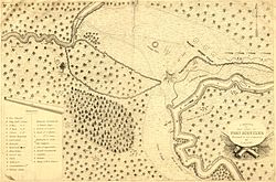
Following the failure of British campaign plans in 1755, a chain of forts along the Mohawk River and up to Lake Ontario were garrisoned during the winter of 1755–1756 to protect the route from a French Invasion and provide a staging area for the invasion of New France. The largest garrison was left at Fort Oswego, at the end of the chain, which depended on the others for its supplies. The two forts occupying either end of the Oneida Carry were a key element of this supply chain. Fort Williams, on the Mohawk, was the larger of the two, while Fort Bull, on Wood Creek, was little more than a palisade surrounding storehouses. In March 1756 this palisade, holding a large amount of supplies for Fort Oswego, would be the scene of the first battle, known to history, to take place on the Oneida Carry. The Battle of Fort Bull lasted only one day, but saw the entire fortification, and the supplies within, destroyed when its powder magazine exploded. [6]

Starting in May 1756 the British refortified the Oneida Carry by adding Fort Craven, Fort Newport, and Fort Wood Creek. However, these forts would only remain until August 1756, when they were destroyed by the British themselves in anticipation of a massive attack by the French Army and Marines after the capture of Fort Oswego. Direct control of the Oneida Carry by the British would not be re-established until two years later with the construction of Fort Stanwix in August 1758. [7]

American Revolution

The Walls of Fort Stanwix Fost FTST3697.jpg
The Walls of Fort Stanwix

Between the end of the French and Indian War and the beginning of the American Revolution the Oneida Carry transformed from a place of war to a place of peace. After Pontiac's Rebellion the British slowly abandoned Fort Stanwix; its believed the last Half Pay Officer left the Fort in June 1774 when Governor William Tryon declared the fort "dismantled". During the inter-war period the carry also became home to the Roof Family- who would establish a tavern, continued to be utilized by merchants to move trade goods into the interior of the continent, and in 1768 saw the signing of the Treaty of Fort Stanwix.

However, during the American Revolutionary War the Oneida Carry once again became a battle ground. With Patriot Forces occupying the carry in August 1776 the Army only had a year to reconstruct Fort Stanwix before the British arrived and laid siege to Fort Stanwix (August 2, 1777 to August 22, 1777). After the successful defense of Fort Stanwix the Oneida Carry saw little military action. In the spring of 1779, as a part of the Sullivan Expedition of 1779, the American Army used the fort as a staging ground for the destruction of Onondaga Castle. In 1780 the garrison was attacked by a large force of Natives led by Joseph Brant forcing a three-day standoff between the Patriot Troops in the well-defended Fort Stanwix and the poorly defended Loyalist Natives. In general the most military action seen by the garrison was the occasional harassment by bands of Loyalist Raiding Parties moving into the Mohawk Valley. Which is not to downplay the many lives lost by those soldiers who were unexpectedly attacked, but to re-enforce the idea that garrison duty on the carry became extremely boring. Finally, in the spring of 1781, when flood and fire (most likely arson) destroyed most of the fort, the American Troops evacuated the post; only to return in 1784 to sign the Second Treaty of Fort Stanwix, ending the American Revolution with those Native Americans who sided with the British.

19th Century and Beyond

The carry as depicted on Thomas Kitchin's map of 1772 OneidaCarryKitchen1772.png
The carry as depicted on Thomas Kitchin's map of 1772

After the war the Oneida Carry continued to be of economic importance. Established in 1792 the Western Inland Lock Navigation Company constructed a canal between the Mohawk River and Wood Creek. With this canal boats no longer had to be removed from the River and carried over the portage. These canals would have continued use until 1817 when the Erie Canal began construction within the new City of Rome.

The carry also saw a continuation of its military importance throughout the 1800s and up to the 21st Century. Built in 1813 and used until 1873, the Rome Arsenal was a three-acre fortification complex which included barracks, arsenal, magazine, workshops, and other buildings, built to support American forces waging the War of 1812, Mexican–American War, and the American Civil War. This post actually replaced an early armory, constructed and utilized in the late 1790s which was located on the site of, the then demolished, Fort Stanwix.

Starting on 3 April 1941, the War Department began looking for an area to construct an Air Depot in central New York and thus the Oneida Carry would once again become an important part of the Nations Defense. Opened in February 1942 Griffiss Air Force Base would become home to the Rome Labs, the 416th Air Expeditionary Group and Strategic Air Command. Currently the now closed Air Force Base is the home for the Northeast Air Defense Sector facilities which provides detection and air defense for the entire eastern half of the United States.

The city of Rome, with a population of 33,725 at the 2010 census and the second largest city in the State of New York by area (75.7 square miles), now encompasses most of what was once the Oneida Carry. Rome Free Academy, the high school for the city of Rome, refers to their yearbook as the "De-O-Wain-Sta" in honor of the Oneida Carry. [8]

Related Research Articles

<span class="mw-page-title-main">Oneida County, New York</span> County in New York, United States

Oneida County is a county in the state of New York, United States. As of the 2020 census, the population was 232,125. The county seat is Utica. The name is in honor of the Oneida, one of the Five Nations of the Iroquois League or Haudenosaunee, which had long occupied this territory at the time of European encounter and colonization. The federally recognized Oneida Indian Nation has had a reservation in the region since the late 18th century, after the American Revolutionary War.

<span class="mw-page-title-main">Oriskany, New York</span> Village in New York, United States

Oriskany is a village in Oneida County, New York, United States. The population was 1,400 at the 2010 census. The name is derived from the Iroquois word for "nettles".

<span class="mw-page-title-main">Rome, New York</span> City in upstate New York

Rome is a city in Oneida County, New York, United States, located in the central part of the state. The population was 32,127 at the 2020 census. Rome is one of two principal cities in the Utica–Rome Metropolitan Statistical Area, which lies in the "Leatherstocking Country" made famous by James Fenimore Cooper's Leatherstocking Tales, set in frontier days before the American Revolutionary War. Rome is in New York's 22nd congressional district.

<span class="mw-page-title-main">Fort Oswego</span> 18th-century trading post in the Great Lakes region in North America

Fort Oswego was an 18th-century trading post in the Great Lakes region in North America, which became the site of a battle between French and British forces in 1756 during the French and Indian War. The fort was established in 1727, on the orders of New York governor William Burnet, adjacent to a 1722 blockhouse that had originally been a way station for French traders. The log palisade fort established a British presence on the Great Lakes.

<span class="mw-page-title-main">Mohawk River</span> River in the U.S. state of New York

The Mohawk River is a 149-mile-long (240 km) river in the U.S. state of New York. It is the largest tributary of the Hudson River. The Mohawk flows into the Hudson in Cohoes, New York, a few miles north of the state capital of Albany. The river is named for the Mohawk Nation of the Iroquois Confederacy. A major waterway, in the early 19th century, the river's east-west valley provided the setting and water for development of the Erie Canal, as a key to developing New York. The largest tributary, the Schoharie Creek, accounts for over one quarter (26.83%) of the Mohawk River's watershed. Another main tributary is the West Canada Creek, which makes up for 16.33% of the Mohawk's watershed.

<span class="mw-page-title-main">Mohawk Valley</span> Six-county region in New York, United States

The Mohawk Valley region of the U.S. state of New York is the area surrounding the Mohawk River, sandwiched between the Adirondack Mountains and Catskill Mountains, northwest of the Capital District. As of the 2010 United States Census, the region's counties have a combined population of 622,133 people. In addition to the Mohawk River valley, the region contains portions of other major watersheds such as the Susquehanna River.

<span class="mw-page-title-main">Battle of Oriskany</span> 1777 battle of the American Revolutionary War

The Battle of Oriskany was a significant engagement of the Saratoga campaign of the American Revolutionary War, and one of the bloodiest battles in the conflict between Patriot forces and those loyal to Great Britain. On August 6, 1777, several hundred of Britain's Indigenous allies, accompanied by Loyalists of the King's Royal Regiment of New York and the British Indian Department, ambushed a Patriot militia column which was marching to relieve the siege of Fort Stanwix. This was one of the few battles in which the majority of the participants were American colonists. Patriots and allied Oneidas fought against Loyalists and allied Iroquois and Mississaugas. No British regulars were involved; however, a detachment of Hessians was present.

<span class="mw-page-title-main">Fort Stanwix</span> United States historic place

Fort Stanwix was a colonial fort whose construction commenced on August 26, 1758, under the direction of British General John Stanwix, at the location of present-day Rome, New York, but was not completed until about 1762. The bastion fort was built to guard a portage known as the Oneida Carry during the French and Indian War. Fort Stanwix National Monument, a reconstructed structure built by the National Park Service, now occupies the site.

<span class="mw-page-title-main">Oneida Lake</span> Lake in New York state

Oneida Lake is the largest lake entirely within New York state, with a surface area of 79.8 square miles (207 km2). The lake is located northeast of Syracuse and near the Great Lakes. It feeds the Oneida River, a tributary of the Oswego River, which flows into Lake Ontario. From the earliest times until the opening of the Erie Canal in 1825, the lake was part of an important waterway connecting the Atlantic seaboard of North America to the continental interior.

<span class="mw-page-title-main">Battle of Fort Oswego</span> French and Indian War battle

The Battle of Fort Oswego was one in a series of early French victories in the North American theatre of the Seven Years' War won in spite of New France's military vulnerability. During the week of August 10, 1756, a force of regulars and Canadian militia under General Montcalm captured and occupied the British fortifications at Fort Oswego, located at the site of present-day Oswego, New York.

<span class="mw-page-title-main">Battle of Fort Frontenac</span> Battle of the French and Indian War

The Battle of Fort Frontenac took place on August 26–28, 1758 during the Seven Years' War between France and Great Britain. The location of the battle was Fort Frontenac, a French fort and trading post which is located at the site of present-day Kingston, Ontario, at the eastern end of Lake Ontario where it drains into the St. Lawrence River.

<span class="mw-page-title-main">King's Royal Regiment of New York</span> Military unit

The King's Royal Regiment of New York, also known as Johnson's Royal Regiment of New York, King's Royal Regiment, King's Royal Yorkers, and Royal Greens, were one of the first Loyalist regiments, raised on June 19, 1776, in British Canada, during the American Revolutionary War.

<span class="mw-page-title-main">Battle of Fort Oswego (1814)</span>

The Battle of Fort Ontario was a partially successful British raid on Fort Ontario and the village of Oswego, New York on May 6, 1814 during the War of 1812.

<span class="mw-page-title-main">Battle of Big Sandy Creek</span>

The Battle of Big Sandy Creek was fought in northwestern New York on May 29–30, 1814, during the War of 1812. American troops and Oneida Indians launched an attempted surprise attack on British troops and sailors, who were pursuing them inland from Lake Ontario.

The Battle of Fort Bull was a French attack on the British-held Fort Bull on 27 March 1756, early in the French and Indian War. The fort was built to defend a portion of the waterway connecting Albany, New York to Lake Ontario via the Mohawk River.

<span class="mw-page-title-main">New York State Route 46</span> State highway in central New York, US

New York State Route 46 (NY 46) is a state highway in Central New York in the United States. It extends from NY 12B in the Madison County town of Eaton to NY 12D in the Oneida County village of Boonville. NY 46 passes through the cities of Oneida and Rome.

Fort Bull was located at the Oneida Carry in British North America during the French and Indian War.

The Battle of Klock's Field was an engagement during the American Revolutionary War in the Mohawk Valley region of New York between British, Loyalist and Iroquois forces led by Lieutenant Colonel Sir John Johnson, and New York Levies and militia led by Brigadier General Robert Van Rensselaer. The battle occurred on the north side of the Mohawk River in what is now St. Johnsville in Montgomery County. The result was inconclusive with neither side able to claim a clear victory.

<span class="mw-page-title-main">Siege of Fort Stanwix</span> Part of American Revolutionary War

The siege of Fort Stanwix began on August 2, 1777 and ended on August 22, 1777. Fort Stanwix, at the western end of the Mohawk River Valley, was a primary defense point for the Continental Army against the British and indigenous forces aligned against them during the American Revolutionary War. The fort was occupied by Continental Army forces from New York and Massachusetts under the command of Colonel Peter Gansevoort. The besieging force was composed of British regulars, Loyalist soldiers, Hessians, and indigenous warriors, under the command of Brigadier General Barry St. Leger. St. Leger's expedition was a diversion in support of Lieutenant General John Burgoyne's campaign to take control of the Hudson River Valley to the east.

<span class="mw-page-title-main">Wood Creek</span> River in Central New York State

Wood Creek is a river in Central New York State that flows westward from the city of Rome, New York to Oneida Lake. Its waters flow ultimately to Lake Ontario, which is the easternmost of the five Great Lakes. Wood Creek is less than 20 miles (32 km) long, but has great historical importance. Wood Creek was a crucial, fragile link in the main 18th and early 19th century waterway connecting the Atlantic seaboard of North America and its interior beyond the Appalachian Mountains. This waterway ran upstream from the Hudson River along the Mohawk River. Near present day Rome, the Mohawk River is about one mile from Wood Creek across dry land. In the 18th century, cargo and boats were portaged between the Mohawk and Wood Creek; the crossing was called the "Oneida Carry". In 1797, the Rome Canal was completed and finally established an all-water route. The waterway then followed a downstream run along Wood Creek to the east end of Oneida Lake. After a 20 mile crossing to the west end of the lake, the waterway entered the Oswego River system. This system led either to the Lake Ontario port at Oswego, or further westward along the Seneca River.

References

  1. Child, Hamilton (1869). Gazetteer and business directory of Oneida County. Syracuse, NY: Printed at the Journal office. p. 105.
  2. Jones, Pomroy (1851). Annals and recollections of Oneida County. Rome, New York: Published by the author. p. 872.
  3. Lord, Jr., Philip L. (1993). The Neck on Mohawcks River - New York's First Canal. The Canal Society of New York State. Archived from the original on 2012-09-24.
  4. Hill, Henry Wayland (1908). An Historical Review of Waterways and Canal Construction in New York State. Publications of the Buffalo Historical Society. Vol. 12. Buffalo Historical Society. p. 31. In July, 1702, representatives of the Five Nations located in Central New York appealed to Lord Cornbury, Captain General and Governor in Chief of New York, among other things concerning trade at Albany, and prayed that 'ye Path over ye Carrying Place may be marked upon ye Trees and ye old Trees taken out of ye Creek (Wood) which much injures ye Passage of Canoes, and will much facilitate their coming hither (to Albany).' Synopsis from a still earlier book.
  5. Minor, David (2004). "Third Winter Meeting Talk, 2004". Archived from the original on 2008-05-16. Transcript of a talk given to the Canal Society of New York.
  6. Parkman, Francis (1910). "Chapter XI: 1712-1756". Montcalm and Wolfe: France and England in North America, Part Seventh, Volume 1. New York: Little, Brown, and Co. pp. 374–378. ISBN   9781548443016.. First published in 1884; see the book's article, Montcalm and Wolfe , for other editions.
  7. Sawyer, William. "The Oneida Carry and Its Early Fortifications: 1755-1757".
  8. "De-O-Wain-Sta" . Retrieved September 20, 2020.