Related Research Articles

Light rail transit (LRT) is a form of passenger urban rail transit characterized by a combination of tram and rapid transit features. While its rolling stock is similar to that of a traditional tram, it operates at a higher capacity and speed and often on an exclusive right-of-way. In many cities, light rail transit systems more closely resemble, and are therefore indistinguishable from, traditional underground or at-grade subways and heavy-rail metros.

Speed limits on road traffic, as used in most countries, set the legal maximum speed at which vehicles may travel on a given stretch of road. Speed limits are generally indicated on a traffic sign reflecting the maximum permitted speed, expressed as kilometres per hour (km/h) or miles per hour (mph) or both. Speed limits are commonly set by the legislative bodies of national or provincial governments and enforced by national or regional police and judicial authorities. Speed limits may also be variable, or in some places nonexistent, such as on most of the Autobahnen in Germany.
Level of service (LOS) is a qualitative measure used to relate the quality of motor vehicle traffic service. LOS is used to analyze roadways and intersections by categorizing traffic flow and assigning quality levels of traffic based on performance measure like vehicle speed, density, congestion, etc. In a more general sense, levels of service can apply to all services in asset management domain.

Road traffic safety refers to the methods and measures used to prevent road users from being killed or seriously injured. Typical road users include pedestrians, cyclists, motorists, vehicle passengers, and passengers of on-road public transport.
The American Association of State Highway and Transportation Officials (AASHTO) is a standards setting body which publishes specifications, test protocols, and guidelines that are used in highway design and construction throughout the United States. Despite its name, the association represents not only highways but air, rail, water, and public transportation as well.

A limited-access road, known by various terms worldwide, including limited-access highway, dual-carriageway, expressway, and partial controlled-access highway, is a highway or arterial road for high-speed traffic which has many or most characteristics of a controlled-access highway, including limited or no access to adjacent property, some degree of separation of opposing traffic flow, use of grade separated interchanges to some extent, prohibition of slow modes of transport, such as bicycles, horse-drawn vehicles or ridden horses, or self-propelled agricultural machines; and very few or no intersecting cross-streets or level crossings. The degree of isolation from local traffic allowed varies between countries and regions. The precise definition of these terms varies by jurisdiction.
Standards for Interstate Highways in the United States are defined by the American Association of State Highway and Transportation Officials (AASHTO) in the publication A Policy on Design Standards: Interstate System. For a certain highway to be considered an Interstate Highway, it must meet these construction requirements or obtain a waiver from the Federal Highway Administration.

In the field of road transport, an interchange or a grade-separated junction is a road junction that uses grade separations to allow for the movement of traffic between two or more roadways or highways, using a system of interconnecting roadways to permit traffic on at least one of the routes to pass through the junction without interruption from crossing traffic streams. It differs from a standard intersection, where roads cross at grade. Interchanges are almost always used when at least one road is a controlled-access highway or a limited-access divided highway (expressway), though they are sometimes used at junctions between surface streets.
Stopping sight distance is one of several types of sight distance used in road design. It is a near worst-case distance a vehicle driver needs to be able to see in order to have room to stop before colliding with something in the roadway, such as a pedestrian in a crosswalk, a stopped vehicle, or road debris. Insufficient sight distance can adversely affect the safety or operations of a roadway or intersection.
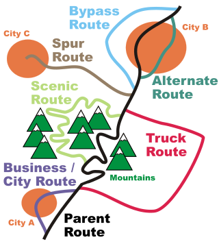
In road transportation in the United States, a special route is a road in a numbered highway system that diverts a specific segment of related traffic away from another road. They are featured in many highway systems; most are found in the Interstate Highway System, U.S. highway system, and several state highway systems. Each type of special route possesses generally defined characteristics and has a defined relationship with its parent route. Typically, special routes share a route number with a dominant route, often referred as the "parent" or "mainline", and are given either a descriptor which may be used either before or after the route name, such as Alternate or Business, or a letter suffix that is attached to the route number. For example, an alternate route of U.S. Route 1 may be called "Alternate U.S. Route 1", "U.S. Route 1 Alternate", or "U.S. Route 1A". Occasionally, a special route will have both a descriptor and a suffix, such as U.S. Route 1A Business.
The design speed is a tool used to determine geometric features of a new road or street during road design. Contrary to the word's implication, the design speed of the road or street is not necessarily its vehicle speed limit or maximum safe speed; that can be higher or lower.

Highway 396 is a former state highway near Burlington in Boone County. Between its designation as a state highway in 1973 and its decommissioning to the county road system in 2016, it was maintained by the Arkansas Department of Transportation (ArDOT).

The geometric design of roads is the branch of highway engineering concerned with the positioning of the physical elements of the roadway according to standards and constraints. The basic objectives in geometric design are to optimize efficiency and safety while minimizing cost and environmental damage. Geometric design also affects an emerging fifth objective called "livability," which is defined as designing roads to foster broader community goals, including providing access to employment, schools, businesses and residences, accommodate a range of travel modes such as walking, bicycling, transit, and automobiles, and minimizing fuel use, emissions and environmental damage.

Highway 179 is a north–south state highway in Franklin County, Arkansas. Since 1998, the state highway designation has run from a county road intersection at the unincorporated community of Greenwood to US Highway 64 (US 64) in Altus. The highway is maintained by the Arkansas Department of Transportation (ArDOT).

Highway 336 is a designation for two east–west state highways in the Arkansas Ozarks. Both are low traffic, two-lane, highways near Greers Ferry Lake. The longer segment was created in 1966, with the Higden segment created in 1972. Both current segments are maintained by the Arkansas Department of Transportation (ArDOT).
Speed limits in the Philippines are specified in Republic Act No. 4136, or the Land Transportation and Traffic Code of the Philippines, which took effect on its approval on June 20, 1964. The act covers a number of areas other areas than speed limits, and was amended regarding some of those areas by Republic Act No. 10930, which was approved on August 2, 2017.

Highway 291 is a north–south state highway in Grant County, Arkansas. The highway connects minor population centers in western Grant County. Established in 1963, the state highway designation was extended to Traskwood from 1965 to 1995, when it was truncated at Tull, forming the current alignment. The highway is maintained by the Arkansas Department of Transportation (ArDOT).

Highway 267 is a designation for two state highways in White County. One route of 15.47 miles (24.90 km) begins at Highway 31 and runs northeast to Highway 367 in Searcy. A second route of 2.25 miles (3.62 km) begins at Highway 31 and runs east to Highway 13. Highway 267 Spur, a spur route of 0.90 miles (1.45 km) connects Highway 267 and Highway 31 north of Beebe. The highways are maintained by the Arkansas Department of Transportation (ARDOT).
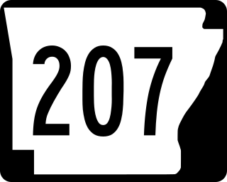
Highway 207 is a north–south state highway in Dallas County, Arkansas. It was created in 1962 along a former county road. The route is maintained by the Arkansas Department of Transportation (ArDOT). A former designation in the same vicinity was deleted in 1973.
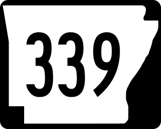
Highway 339 is a short state highway in Woodruff County, Arkansas. The highway is maintained by the Arkansas Department of Transportation (ArDOT).
References
- ↑ A Policy on Geometric Design of Highways and Streets: 1994. American Association of State Highway and Transportation Officials. ISBN 1-56051-068-4.
- ↑ "Design Speed, Operating Speed, and Posted Speed Practices (Report 504)" (PDF). National Cooperative Highway Research Program.
- ↑ A Policy on Geometric Design of Highways and Streets: 2001. American Association of State Highway and Transportation Officials. ISBN 1-56051-156-7.
| | This road-related article is a stub. You can help Wikipedia by expanding it. |