Qeqertarsuaq is a port and town in Qeqertalik municipality, located on the south coast of Disko Island on the west coast of Greenland. Founded in 1773, the town is now home to a campus of the University of Copenhagen known as Arctic Station. Qeqertarsuaq is the Kalaallisut name for Disko Island and is also now used for several other islands on Greenland, including those formerly known as Upernavik and Herbert Island. Qeqertarsuaq means ‘the big island’ in Kalaallisut.

Air Greenland A/S, also known as Greenlandair, is the flag carrier airline of Greenland, owned by the Greenlandic Government. It operates a fleet of 32 aircraft, including 1 airliner used for transatlantic and charter flights, 8 fixed-wing aircraft primarily serving the domestic network, and 18 helicopters feeding passengers from the smaller communities into the domestic airport network. Flights to heliports in the remote settlements are operated on contract with the government of Greenland.

Uummannaq Island is a small (12 km2) island in Avannaata municipality in northwestern Greenland. Located in the south-central part of the Uummannaq Fjord, it is home to the most prominent mountain on the Arctic coast of western Greenland and to Uummannaq, the largest town north of Ilulissat.

Disko Bay is a large bay on the western coast of Greenland. The bay constitutes a wide southeastern inlet of Baffin Bay.

Qasigiannguit, formerly Christianshåb, is a town located in western Greenland on the southeastern shore of Disko Bay in the Qeqertalik municipality. With 1,081 inhabitants in 2020, it is the thirteenth-largest town in Greenland. The main industry is shrimp and halibut fishing.

Sisimiut, formerly known as Holsteinsborg, is the capital and largest city of the Qeqqata municipality, the second-largest city in Greenland, and the largest arctic city in North America. It is located in central-western Greenland, on the coast of Davis Strait, approximately 320 km (200 mi) north of Nuuk.

Niaqornaarsuk is a village in the Qeqertalik municipality in western Greenland, along the northern entrance to Arfersiorfik Fjord. Its population was 249 in 2020.
Nuussuaq, formerly Kraulshavn, is a settlement in Avannaata municipality in northwestern Greenland. It is the only mainland settlement in the Upernavik Archipelago, located near the western tip of the Nuussuaq Peninsula, on the northern coast of Sugar Loaf Bay, an indentation of Baffin Bay.
Ikamiut is a settlement in the Qeqertalik municipality in western Greenland, located on a small island in the Aasiaat Archipelago on the southern shores of Disko Bay. Its population was 86 in 2020.
Saqqaq is a settlement in the Avannaata municipality in western Greenland. Founded in 1755 as Solsiden, Saqqaq had 132 inhabitants in 2020. The village's Kalaallisut name is a translation of the Danish meaning "Sunny Side", in reference to its position relative to Livets Top.

Qeqertaq is a settlement in the Avannaata municipality in western Greenland, located on an island off the southern shore of the Nuussuaq Peninsula in an inlet of Sullorsuaq Strait. Founded in 1830 as Øen, the settlement had 114 inhabitants in 2020.

Ilimanaq, formerly Claushavn, is a settlement in Avannaata municipality in western Greenland. It had 53 inhabitants in 2020. The modern name of the village is Kalaallisut for "Place of Expectations".

Ukkusissat is a settlement in Avannaata municipality, in northwestern Greenland. The population of the settlement was 154 in 2020. The name means soapstone.
Qaasuitsup was a municipality in Greenland, operational from 1 January 2009 to 31 December 2017. As of January 2013 its population was 17,498. The administrative centre of the municipality was in Ilulissat.

Ilulissat Airport ; is a minor international airport serving Ilulissat, Greenland, the entire Disko Bay Region, the North and West Greenland. It is the 59th largest airport in the Nordic countries with 83,000 passengers in 2012 and is the second airport built in Greenland for civilian travel partially funded by the EU Structural Funds and Cohesion Fund. It is the third-busiest airport in Greenland, and by far one of the busiest for international travel in Greenland.

Qaarsut Airport is an airport in Qaarsut, a settlement on the Nuussuaq Peninsula in Avannaata municipality in northwestern Greenland. It is a primary airport with a gravel runway, capable of serving STOL aircraft of Air Greenland in all seasons. There is a small cafeteria in the tiny arrivals/departures hall. It is connected by a 4 km (2.5 mi) gravel road to Qaarsut and is 13.5 nautical miles northwest of Uummannaq.
Qeqertaq Heliport is a heliport in Qeqertaq, a village on an island off the shore of the Nuussuaq Peninsula in Avannaata municipality in western Greenland. The heliport is considered a helistop, and is served by Air Greenland as part of a government contract.
Upernavik Archipelago is a vast coastal archipelago in the Avannaata municipality in northwestern Greenland, off the shores of northeastern Baffin Bay. The archipelago extends from the northwestern coast of Sigguup Nunaa peninsula in the south at approximately 71°50′N56°00′W to the southern end of Melville Bay in the north at approximately 74°50′N57°30′W.
Disko Line A/S is a passenger and freight ferry line in western Greenland. It was founded in 2004 as a small freight company.

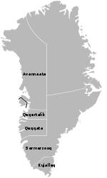
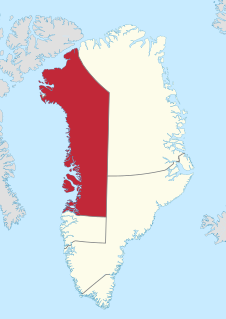
Avannaata, is a municipality of Greenland created on 1 January 2018 from the bulk of the former Qaasuitsup municipality. It encompasses an area of 522,700 km2 and has 10,726 inhabitants.