
Table Mountain is a flat-topped mountain forming a prominent landmark overlooking the city of Cape Town in South Africa. It is a significant tourist attraction, with many visitors using the cableway or hiking to the top. Table Mountain National Park is the most visited national park in South Africa, attracting 4.2 million people every year for various activities. The mountain has 8,200 plant species, of which around 80% are fynbos, meaning fine bush. It forms part of the Table Mountain National Park, and part of the lands formerly ranged by Khoe-speaking clans, such as the !Uriǁʼaes. It is home to a large array of mostly endemic fauna and flora.

Table Bay is a natural bay on the Atlantic Ocean overlooked by Cape Town and is at the northern end of the Cape Peninsula, which stretches south to the Cape of Good Hope. It was named because it is dominated by the flat-topped Table Mountain.

Cape Point is a promontory at the southeast corner of the Cape Peninsula, a mountainous and scenic landform that runs north-south for about thirty kilometres at the extreme southwestern tip of the African continent in South Africa. Table Mountain and the city of Cape Town are close to the northern extremity of the same peninsula. The cape is located at 34°21′26″S18°29′51″E, about 2.3 kilometres (1.4 mi) east and a little north of the Cape of Good Hope on the southwest corner. Although these two rocky capes are very well known, neither cape is actually the southernmost point of the mainland of Africa; that is Cape Agulhas, approximately 150 kilometres (93 mi) to the east-southeast.

The Cape Peninsula is a generally mountainous peninsula that juts out into the Atlantic Ocean at the south-western extremity of the African continent. At the southern end of the peninsula are Cape Point and the Cape of Good Hope. On the northern end is Table Mountain, overlooking Table Bay and the city bowl of Cape Town, South Africa. The peninsula is 52 km long from Mouille point in the north to Cape Point in the south. The Peninsula has been an island on and off for the past 5 million years, as sea levels fell and rose with the ice age and interglacial global warming cycles of, particularly, the Pleistocene. The last time that the Peninsula was an island was about 1.5 million years ago. Soon afterwards it was joined to the mainland by the emergence from the sea of the sandy area now known as the Cape Flats. The towns and villages of the Cape Peninsula and Cape Flats, and the undeveloped land of the rest of the peninsula now form part of the City of Cape Town metropolitan municipality. The Cape Peninsula is bounded to the north by Table Bay, to the west by the open Atlantic Ocean, and to the east by False Bay in the south and the Cape Flats in the north.

Constantiaberg is a large, whalebacked mountain that forms part of the mountainous spine of the Cape Peninsula in Table Mountain National Park, Cape Town, South Africa. It lies about 7 km south of Table Mountain, on the southern side of Constantia Nek. The mountain is 927 m high. It is not known who first ascended the peak.

Chapman's Peak is a mountain on the western side of the Cape Peninsula, between Hout Bay and Noordhoek in Cape Town, South Africa. The western flank of the mountain falls sharply for hundreds of metres into the Atlantic Ocean, and a road, known as Chapman's Peak Drive, hugs the near-vertical face of the mountain, linking Hout Bay to Noordhoek. Tourists and locals often stop at viewpoints along this road, which offer views of Hout Bay, The Sentinel Peak and surrounds, as well as over Noordhoek Beach.
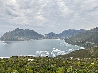
Hout Bay is a harbour town in the Western Cape province of South Africa. It is situated in a valley on the Atlantic seaboard of the Cape Peninsula, twenty kilometres south of Cape Town. The name "Hout Bay" can refer to the town, the bay on which it is situated, or the entire valley.

Noordhoek is a seaside town in the Western Cape, South Africa, located below Chapman's Peak on the west coast of the Cape Peninsula and is approximately 35 kilometres (22 mi) to the south of Cape Town. The name "Noordhoek" was taken from Dutch and literally means "north corner". It was given this name in 1743 as being the northern corner of the Slangkop farm. The first permanent resident of European origin is Jaco Malan who built his house there. In 1857, the region was divided into six plots, most of which were bought by a single family, that of the de Villiers. Noordhoek nevertheless remains a predominantly rural area where farmers grow vegetables to supply ships calling at Simon's Town. It is best known for its shoreline and its long, wide, sandy beach, which stretches south to the neighbouring village of Kommetjie. Near the southern end of this beach is the wreck of the steamship "Kakapo", which ran aground in 1900, when the captain mistook Chapman's Peak for the Cape of Good Hope and put the helm over to port.
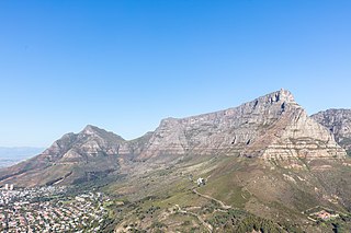
Table Mountain National Park, previously known as the Cape Peninsula National Park, is a national park in Cape Town, South Africa, proclaimed on 29 May 1998, for the purpose of protecting the natural environment of the Table Mountain Chain, and in particular the rare fynbos vegetation. The park is managed by South African National Parks. The property is included as part of the UNESCO Cape Floral Region World Heritage Site.

The City Bowl is a part of Cape Town in South Africa. It is a natural amphitheatre-shaped area bordered by Table Bay and defined by the mountains of Signal Hill, Lion's Head, Table Mountain and Devil's Peak.
Sandy Bay is a nudist beach just south of Llandudno. It is on the west side of the Karbonkelberg, and cannot be seen from the main road to Hout Bay, which turns inland above Llandudno.

Woodhead Dam is a dam on Table Mountain, Western Cape, South Africa. It was built in 1897 and supplies water to Cape Town. The dam, which was the first large masonry dam in South Africa, was designated as an International Historic Civil Engineering Landmark by the American Society of Civil Engineers in 2008.

Constantia Nek is a low pass over the Table Mountain range in Cape Town, South Africa, linking Constantia to Hout Bay in the west. It is one of three passes connecting Hout Bay to the rest of the city, and, with Ou Kaapse Weg is one of the two passes over the mountain range between the city centre and the Fish Hoek valley.
Dozens of fortifications were built in Cape Town and the Cape Peninsula between the 1650s and the 1940s. Most have gone, but a few still stand.

The Table Mountain Challenge is a 37 km mountain trail run annually clockwise around Table Mountain and Devil's Peak, South Africa and consisting mostly of single track with a few kilometers of jeep track. The trail involves a great amount of scrambling, passing through an indigenous forest and crossing mountain streams, steep slopes of fynbos and views.

The Sentinel or Hangberg is a peak marking the western end of the mouth of Hout Bay in South Africa. It has a shear cliff dropping towards the sea, and a coastal hiking path is accessible at low tide. It is adjacent to Hout Bay Harbour and the Hangberg settlement, and to the higher Karbonkelberg peak. Just offshore to the south is a colony of Cape fur seals known as Seal Island, and a big wave surf spot known as "Dungeons", which has hosted the Red Bull Big Wave Africa competition.
Kloof Nek Road, one of South Africa's oldest roads, was built in 1848 as an access road for the suburban pass with the same name which was used primarily as a look-out post for soldiers and a supply route to Camps Bay. The route starts at Kloof Street on the edge of the city bowl and turns into Camps Bay Road at the end of a mountain pass running between Table Mountain and Lion's Head. Despite being only two kilometers long, it is very steep with an average gradient 1:11. The summit of Kloof Nek Road is a small but complicated intersection that's not clearly visible on approach and often catch motorists unawares. The road's steepness may be a contributor the regular occurrence of often-fatal accidents on Kloof Nek Road.
The Table Mountain National Park Marine Protected Area is an inshore marine protected area around the Cape Peninsula, in the vicinity of Cape Town, South Africa. It was proclaimed in Government Gazette No. 26431 of 4 June 2004 in terms of the Marine Living Resources Act, 18 of 1998.
The following outline is provided as an overview of and topical guide to Cape Town:
The Twelve Apostles are part of the Table Mountain complex overlooking Camps Bay. The mountain range stretches 6 km almost to Hout Bay. They actually consist of 18 peaks including St. Peter's Peak, St. Luke's Peak, and Judas Peak. The average height above sea level is 750 m, compared to 1,060 m for Table Mountain. Under the Dutch East India Company, the range was known as the Castle Mountains or Gable Mountains.

