The Rock of Gibraltar is a monolithic limestone promontory located in the British territory of Gibraltar, near the southwestern tip of Europe on the Iberian Peninsula. It is 426 m (1,398 ft) high. Most of the Rock's upper area is covered by a nature reserve, which is home to around 300 Barbary macaques. These macaques, as well as a labyrinthine network of tunnels, attract many tourists each year.

The Royal Gibraltar Regiment is the home defence unit, part of British Forces Gibraltar for the British overseas territory of Gibraltar. It was formed in 1958 from the Gibraltar Defence Force as an infantry unit, with an integrated artillery troop. The Regiment is included in the British Army as a defence engagement force. In 1999, the regiment was granted the Royal title. The Regiment recruits from Gibraltar, the United Kingdom, Republic of Ireland and the Commonwealth.

The Great Siege Tunnels in the British Overseas Territory of Gibraltar, also known as the Upper Galleries, are a series of tunnels inside the northern end of the Rock of Gibraltar. They were dug out from the solid limestone by the British during the Great Siege of Gibraltar of the late 18th century.

Hohlgangsanlage are a number of tunnels constructed in Jersey by occupying German forces during the occupation of Jersey. The Germans intended these bunkers to protect troops and equipment from aerial bombing and to act as fortifications in their own right.

Parson's Lodge Battery is a coastal battery and fort in the British Overseas Territory of Gibraltar.

Princess Caroline's Battery is an artillery battery in the British Overseas Territory of Gibraltar. It is located at the northern end of the Upper Rock Nature Reserve, at the junction of Willis's Road and Queen's Road. The nearby Princess Anne's Battery is often mistakenly referred to as Princess Caroline's Battery. The latter was built in 1732 and named after Princess Caroline, the daughter of King George II. Princess Caroline's Battery was updated in 1905, and a 6 inch Mark VII gun was mounted above the magazine. Later, the battery was decommissioned and the gun removed. The underground magazine is now home to the Military Heritage Centre, which includes the Memorial Chamber.

Princess Amelia's Battery is an artillery battery in the British Overseas Territory of Gibraltar. It is located on Willis's Plateau at the northern end of the Upper Rock Nature Reserve, adjacent to Gun No. 4 of Princess Anne's Battery. It was named after Princess Amelia of Great Britain, the second daughter of George II. It was formerly referred to as the 2nd Willis's Battery. The plateau and its batteries had previously been named after an artillery officer by the name of Willis who was outstanding during the capture of Gibraltar in 1704. Princess Amelia's Battery saw action during the Great Siege of Gibraltar, during which it sustained substantial damage. Little remains of the original site, aside from two derelict buildings. The battery is listed with the Gibraltar Heritage Trust.

Lord Airey's Battery is an artillery battery in the British Overseas Territory of Gibraltar. It is located near the southern end of the Upper Rock Nature Reserve, just north of O'Hara's Battery. It was named after the Governor of Gibraltar, General Sir Richard Airey. Construction of the battery was completed in 1891. The first gun mounted on the battery was a 6-inch breech loading gun, which was replaced with a 9.2-inch Mark X BL gun by 1900. The gun at the battery was last fired in the 1970s. In 1997, it was discovered that Lord Airey's Shelter, adjacent to Lord Airey's Battery, was the site chosen for a covert World War II operation that entailed construction of a cave complex in the Rock of Gibraltar, to serve as an observation post. The battery is listed with the Gibraltar Heritage Trust.

Rock Gun Battery is an artillery battery in the British Overseas Territory of Gibraltar. It is located on the North Face of the Rock of Gibraltar at the northern end of the Upper Rock Nature Reserve, above Green's Lodge Battery. The emplacement on Middle Hill is at the northern summit of the Rock. It was constructed during the Great Siege of Gibraltar, due to its advantageous position and the success of the gun at Green's Lodge Battery. It was used effectively during the Great Siege and was rebuilt during the Second World War. During the mid-twentieth century, the Ministry of Defence began to use the site as an aerial farm, which was then refurbished in 1958. The Rock Gun Battery and the Middle Hill Battery were closed to the public for decades. In 2005, the radio farm was closed and the Ministry of Defence withdrew from most of the area, transferring it to the Government of Gibraltar. However, the summit, the site of the Rock Gun Battery, continues to be under MOD authority.

Star Chamber Cave is a limestone cave in the British Overseas Territory of Gibraltar. In the 1780s the cave became the centre of tunnels known as the Lower Galleries of the Northern Defences. In 1941 this cave was still in military use as the King's Regiment Battalion Headquarters

Hanover Battery was an artillery battery on the north west part of the British Overseas Territory of Gibraltar. The battery is casemated. Beneath the battery was a tunnel known as Hanover Gallery.

Hayne's Cave Battery is the remains of two gun positions that made up an artillery battery on the west side of the British Overseas Territory of Gibraltar at Hayne's Cave. Gun emplacements can still be visited at this cave.

Signal Hill Battery or Signal Battery was an artillery battery in the British Overseas Territory of Gibraltar. The battery was mounted high on the rock. Little remains today as the Gibraltar Cable Car top station was built on the site of the old battery.

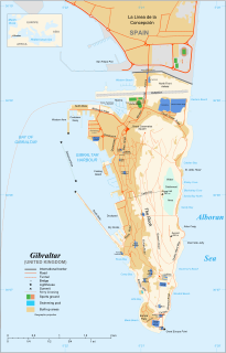
The Gibraltar peninsula, located at the far southern end of Iberia, has great strategic importance as a result of its position by the Strait of Gibraltar where the Mediterranean Sea meets the Atlantic Ocean. It has repeatedly been contested between European and North African powers and has endured fourteen sieges since it was first settled in the 11th century. The peninsula's occupants – Moors, Spanish, and British – have built successive layers of fortifications and defences including walls, bastions, casemates, gun batteries, magazines, tunnels and galleries. At their peak in 1865, the fortifications housed around 681 guns mounted in 110 batteries and positions, guarding all land and sea approaches to Gibraltar. The fortifications continued to be in military use until as late as the 1970s and by the time tunnelling ceased in the late 1960s, over 34 miles (55 km) of galleries had been dug in an area of only 2.6 square miles (6.7 km2).

The Great North Road is a large road tunnel in the British Overseas Territory of Gibraltar. It was constructed by the British military during World War II inside the Rock of Gibraltar and remains property of the Ministry of Defence to this day. The road allowed lorries to travel from the north to the south of Gibraltar entirely within the Rock. The tunnel still contains the remains of World War II buildings such as Nissen huts, kitchens, offices as well as a generating station and period anti-submarine nets.

The King's Lines are a walled rock-cut trench on the lower slopes of the north-west face of the Rock of Gibraltar. Forming part of the Northern Defences of the fortifications of Gibraltar, they were originally created some time during the periods when Gibraltar was under the control of the Moors or Spanish. They are depicted in a 1627 map by Don Luis Bravo de Acuña, which shows their parapet following a tenaille trace. The lines seem to have been altered subsequently, as maps from the start of the 18th century show a more erratic course leading from the Landport, Gibraltar's main land entrance, to the Round Tower, a fortification at their western end. A 1704 map by Johannes Kip calls the Lines the "Communication Line of the Round Tower".
The Queen's Lines are a set of fortified lines, part of the fortifications of Gibraltar, situated on the lower slopes of the north-west face of the Rock of Gibraltar. They occupy a natural ledge which overlooks the landward entrance to Gibraltar and were an extension to the north-east of the King's Lines. They run from a natural fault called the Orillon to a cliff above the modern Laguna Estate, which stands on the site of the Inundation, an artificial lake created to obstruct landward access to Gibraltar. The Prince's Lines run immediately behind and above them on a higher ledge. All three of the Lines were constructed to enfilade attackers approaching Gibraltar's Landport Front from the landward direction.

The tunnels of Gibraltar were constructed over the course of nearly 200 years, principally by the British Army. Within a land area of only 2.6 square miles (6.7 km2), Gibraltar has around 34 miles (55 km) of tunnels, nearly twice the length of its entire road network. The first tunnels, excavated in the late 18th century, served as communication passages between artillery positions and housed guns within embrasures cut into the North Face of the Rock. More tunnels were constructed in the 19th century to allow easier access to remote areas of Gibraltar and accommodate stores and reservoirs to deliver the water supply of Gibraltar.
The Prince's Lines are part of the fortifications of Gibraltar, situated on the lower slopes of the north-west face of the Rock of Gibraltar. They are located at a height of about 70 feet (21 m) on a natural ledge above the Queen's Lines, overlooking the landward entrance to Gibraltar, and run from a natural fault called the Orillon to a cliff at the southern end of the isthmus linking Gibraltar with Spain. The lines face out across the modern Laguna Estate, which stands on the site of the Inundation, an artificial lake created to obstruct landward access to Gibraltar. They were constructed to enfilade attackers approaching Gibraltar's Landport Front from the landward direction.

Mediterranean Steps is a path and nature trail in the British Overseas Territory of Gibraltar. One of the footpaths of Gibraltar, the path is located entirely within the Upper Rock Nature Reserve and was built by the British military but is now used by civilians as a pedestrian route linking Martin's Path to Lord Airey's Battery near the summit of Rock of Gibraltar. The path offers views over the Strait of Gibraltar, Windmill Hill, Europa Point, the Great Sand Dune, Gibraltar's east side beaches, the Mediterranean Sea and the Spanish Costa del Sol.


