Orwell Bridge

Last updated

Orwell Bridge
Orwell-Bridge.jpg
The Orwell Bridge from Orwell Country Park
Coordinates 52°01′37″N1°09′52″E / 52.026909°N 1.16449°E / 52.026909; 1.16449
OS grid reference TM163445
CarriesMotor vehicles (A14 and A12)
Crosses River Orwell (Freston Reach), B1456
Locale Ipswich (east) and Wherstead (west)
Maintained by National Highways
Preceded by Stoke Bridge
Characteristics
DesignTwin box girder bridge
Material Pre-stressed reinforced concrete
Total length1,287 metres (4,222 ft) [1]
Width24 metres (79 ft)
Height43 metres (141 ft)
Longest span190 metres (620 ft)
No. of spans18
History
Architect Frederick Gibberd Partners
Engineering design by Sir William Halcrow & Partners [2]
Constructed by Stevin Construction B.V.
Fabrication byHøsveis & Bofa
Construction startOctober 1979
Construction endApril 1982
Construction cost£23.6m
Inaugurated17 December 1982
Location
Orwell Bridge

The Orwell Bridge is a concrete box girder bridge just south of Ipswich in Suffolk, England. Opened to road traffic in 1982, the bridge carries the A14 road (formerly the A45) over the River Orwell.

Contents

History

Design

The main span is 190 metres which, at the time of its construction, was the longest pre-stressed concrete span in use in the UK. The two spans adjacent to the main span are 106m, known as anchor spans. Most of the other spans are 59m. The total length is 1,287 metres from Wherstead to the site of the former Ipswich Airport. The width is 24 metres with an air draft of 43 metres; the bridge had to be at least 41 metres high. The approach roads were designed by CH Dobbie & Partners of Cardiff, [3] later bought by Babtie, Shaw and Morton then Jacobs in 2004.

The bridge is constructed of a pair of continuous concrete box girders with expansion joints that allow for expansion and contraction. The girders are hollow, allowing for easier inspection, as well as providing access for services, including telecom, power, and a 711mm water main from the nearby Alton Water reservoir. The necessary inspections still cause major disruption to traffic every six years; during the inspection in the summer of 2005, the delays caused by lane closures and speed restrictions added between 30 and 60 minutes to journey times during the peak commuting periods.[ citation needed ]

Approach from the east in November 2006, north of Orwell Country Park at the Shell Orwell services Looking West - geograph.org.uk - 280099.jpg
Approach from the east in November 2006, north of Orwell Country Park at the Shell Orwell services

The bridge design took into consideration the impact on the Orwell Estuary, as well as the needs of the port of Ipswich. The location close to the southern edge of Ipswich was deemed convenient for the industrial areas of the West Bank Terminal and Ransomes Industrial Estate on the eastern end. The bridge was set at an angle to the river to get the best relationship to the surrounding terrain.

The air draft of the central span was chosen to be as low as possible without adversely affecting port operations. Although some have said that the resulting hump affects visibility and road safety, there have not been enough incidents causing injury for the Highways Agency to identify it for greater detailed investigation and possible amendments. [5] The consulting engineers were Sir William Halcrow and Partners. Frederick Gibberd Partners worked on the project to ensure the bridge was as sympathetic as possible to its surroundings, with the final design winning the approval of the Royal Fine Art Commission.

The Department for Transport funded the project and, partly because of the bridge, paid for radars and cameras to be installed at the port's Orwell Navigation Service to monitor the river and the bridge.

Construction

Pilings were sunk 40 metres into the river bottom; Pigott Foundations of Ormskirk drilled 1142 piles; the main contractor of the substructure was Stevin Construction B.V., a Dutch company. The main span was constructed using a balanced cantilever technique, casting sections on alternating sides of the pier in a weekly cycle. Høsveis & Bofa of Hønefoss in Norway helped form the box girder (steelwork). The roller bearings were from Maurer AG of Germany. Mageba UK (Swiss) of Bicester supplied the bridge bearings and expansion joints. The pre-stressed concrete box girder sections had VSL tendons and GKN super-strand wire rope. The construction gantries were fabricated by Fairfield Mabey.

View in March 2010 A12 crossing over River Orwell , Ipswich , March 2010 - panoramio.jpg
View in March 2010

It was part of the first section of the Ipswich Bypass; the contracts for the approach roads were given to Costain (£10.7m, eastern) and Cementation (£9.3m, western). For this section of the bypass, Robert McGregor & Sons, subcontracting to Cementation laid 6,900m of concrete in 48 days with a slipform paver; Costain laid 10,400m of concrete in 31 days with a concrete train.

Construction of the bridge began in October 1979 and was completed 1 April 1982. It was opened on 17 December 1982 by David Howell, Baron Howell of Guildford, then the Secretary of State for Transport.

Maintenance

Bridge bearing replacement works were carried out by Jackson Civil Engineering Ltd over the weekend of 11–14 February 2011, during a 52-hour closure of the north deck, carrying the eastbound A14. The new bridge bearings were designed and manufactured by the engineering company, Freyssinet Ltd. [6]

In February 2014, a meeting of various agencies was held to review diversions when it is necessary for the A14 and Orwell Bridge to be closed. [7]

Speed limit

A permanent reduced speed limit of 60 mph was introduced in November 2015 for safety reasons. [8]

Due to high side-winds, the bridge is often closed during storms. [9] To reduce closure time and the pressure it imposes on local roads, in 2021 Highways England installed electronic variable speed limits on the bridge and the approaches each side. During certain high winds conditions, rather than closing the bridge, the speed limit can be reduced from 60mph to 40mph. [10] [11]

View from the air in February 2010 from an aircraft en route to Stansted from Prague Ipswich and the Orwell Bridge - geograph.org.uk - 1716129.jpg
View from the air in February 2010 from an aircraft en route to Stansted from Prague

Structure

The Stour and Orwell Walk passes over the bridge.

Usage

As of 2006 the bridge was used by 60,000 vehicles per day, about 83% of its capacity. [12] In 2006 it was predicted that the bridge is expected to be running over capacity by 2015. [13]

Incidents

Total closures

When the bridge is closed in both directions for more than a short period of time, normally as a safety precaution due to high winds, most of Ipswich's roads are brought to a near-standstill by diverted traffic. [14] [15]

DateDuration (hours)ReasonNote
14 February 20244 hours 45 minsPolice Incident
21-22 January 202418.5 hoursHigh winds Storm Isha
1 December 2023 [16] 12 hoursRoadworksA vehicle carrying survey equipment on the Orwell Bridge during road works had a failed hydraulic unit, which had an extending platform, which was stuck under the bridges surface. A maintenance truck had to be called in from Yorkshire, which caused the worst traffic delays to date in Ipswich.
2 November 20231.5 hoursPolice Incident
2 November 202312 hoursHigh winds Storm Ciarán
18 February 2022 [17] 12 hoursHigh winds Storm Eunice
30 April 2019 [18] 1.5 hoursPolice Incident
16 March 2019 [19] 4 hoursHigh winds
13 March 2019 [20] 8 hoursHigh winds Storm Gareth
29 November 2018 [21] 4 hoursHigh winds
24 January 2018 [22] 5+ hoursHigh winds Storm Georgina
18 January 2018 [23] 3 hoursHigh winds Storm Fionn
3 January 2018 [24] 17 hoursHigh winds Storm Eleanor
20 October 2017 [25] 8 hoursTraffic collisionFatal crash (6:45am to 2:50pm)
23 February 2017 [14] 5+ hoursHigh winds Storm Doris
22 November 2016 [15] [26] 5+ hoursHigh winds Storm Angus
28 March 2016 [27] 5+ hoursHigh Winds Storm Katie
1 July 2015 [28] 0–1 hoursSuicide / Attempted Suicide
15 April 2015 [28] 1-1.5 hoursRoad Traffic Collision
16 December 2014 [28] 1-1.5 hoursPedestrian
29 October 2014 [28] 0–1 hoursSuicide / Attempted Suicide
21 July 2014 [28] 0–1 hoursSuicide / Attempted Suicide
13 June 2014 [28] 0–1 hoursPedestrian
14 February 2014 [29] 5+ hoursHigh winds 2013–14 United Kingdom winter floods
28 October 2013 [30] 5+ hoursHigh winds St. Jude storm
4 March 2012 [28] [31] 5+ hoursRoad Traffic collisionBridge closed from 8pm on 4th to 3am on 5th.

The bridge appears in the 1987 Cold War drama The Fourth Protocol, in which two RAF helicopters are shown flying under it, and at the end of the 2013 film The Numbers Station.

Related Research Articles

<span class="mw-page-title-main">Tsing Ma Bridge</span> Suspension bridge in Hong Kong

Tsing Ma Bridge is a bridge in Hong Kong. It is the world's 16th-longest span suspension bridge, and was the second longest at time of completion. The bridge was named after the two islands it connects, namely Tsing Yi and Ma Wan. It has two decks and carries both road and rail traffic, which also makes it the largest suspension bridge of this type. The bridge has a main span of 1,377 metres (4,518 ft) and a height of 206 metres (676 ft). The span is the longest of all bridges in the world carrying rail traffic.

<span class="mw-page-title-main">River Orwell</span> River in Suffolk, England

The River Orwell flows through the county of Suffolk in England from Ipswich to Felixstowe. Above Ipswich, the river is known as the River Gipping, but its name changes to the Orwell at Stoke Bridge, where the river becomes tidal. It broadens into an estuary at Ipswich, where the Ipswich dock has operated since the 7th century, and then flows into the North Sea at Felixstowe, the UK's largest container port, after joining the River Stour at Shotley forming Harwich harbour.

<span class="mw-page-title-main">A14 road (England)</span> Major road in England

The A14 is a major trunk road in England, running 127 miles (204 km) from Catthorpe Interchange, a major intersection at the southern end of the M6 and junction 19 of the M1 in Leicestershire to the Port of Felixstowe, Suffolk. The road forms part of the unsigned Euroroutes E24 and E30. It is the busiest shipping lane in East Anglia carrying anything from cars to large amounts of cargo between the UK and Mainland Europe.

<span class="mw-page-title-main">A12 road (England)</span> Road in England

The A12 is a major road in Eastern England. It runs north-east/south-west between London and the coastal town of Lowestoft in the north-eastern corner of Suffolk, following a similar route to the Great Eastern Main Line until Ipswich. A section of the road between Lowestoft and Great Yarmouth became part of the A47 in 2017. Between the junctions with the M25 and the A14, the A12 forms part of the unsigned Euroroute E30. Unlike most A roads, this section of the A12, together with the A14 and the A55, has junction numbers as if it were a motorway.

<span class="mw-page-title-main">Mancunian Way</span> Elevated motorway in England

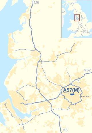
The Mancunian Way is a two mile long grade separated elevated motorway in Manchester, England. It is officially made up of the A57(M) and A635(M) motorways, although the latter does not appear on road signs for practical reasons. It is also part of two other roads: the A57 to the west, which runs east–west through Greater Manchester linking the M602 and M67 motorways, and a short section of non-motorway A635 to the east. Part of this non-motorway section collapsed on 14 August 2015 due to a sinkhole.

<span class="mw-page-title-main">Strelasund Crossing</span> Two bridges in Mecklenburg-Vorpommern, Germany

Strelasund Crossing is the two links to the German island of Rügen (Rugia) over the Strelasund to the West Pomeranian mainland near Stralsund: the Rügen Bridge or Rugia Bridge and the Rugia Causeway.

<span class="mw-page-title-main">Sea Cliff Bridge</span> Bridge in New South Wales, Australia

The Sea Cliff Bridge, together with the adjoining Lawrence Hargrave Drive Bridge, are two road bridges that carry the scenic Lawrence Hargrave Drive across the rockface on the Illawarra escarpment, located in the northern Illawarra region of New South Wales, Australia. The balanced cantilever and incremental launching girder bridges link the coastal villages of Coalcliff and Clifton and carry two lanes of traffic, and a pedestrian walkway.

<span class="mw-page-title-main">Foyle Bridge</span> Bridge in Derry, Northern Ireland

The Foyle Bridge is a bridge in Derry, Northern Ireland. The central span of the bridge is the longest on the island of Ireland, at 234 metres (767 ft), and the whole suspended bridge structure including the approach spans is 866 metres long (2839 ft).

<span class="mw-page-title-main">I-10 Twin Span Bridge</span> Bridge in Louisiana

The I-10 Twin Span Bridge, a nearly 5.5-mile (8.9 km) causeway officially known as the Frank Davis "Naturally N'Awlins" Memorial Bridge, consists of two parallel trestle bridges. These parallel bridges cross the eastern end of Lake Pontchartrain in southern Louisiana from New Orleans to Slidell. The current bridge spans were constructed in the second half of the 2000s after the original bridges were extensively damaged by Hurricane Katrina on August 29, 2005. The first span opened to eastbound traffic on July 9, 2009. On April 7, 2010, the second span was opened to traffic and the old twin spans were permanently closed to traffic.

<span class="mw-page-title-main">Mooney Mooney Bridge</span> Bridge in New South Wales, Australia

The Mooney Mooney Bridge, officially the Mooney Mooney Creek Bridge, and popularly known as The NSW Big Dipper Bridge, is a twin cantilever bridge that carries the Pacific Motorway (M1) across Mooney Mooney Creek, located near Mooney Mooney in the Brisbane Water National Park on the Central Coast of New South Wales, Australia. The concrete box girder bridge was opened on 14 December 1986 by the Prime Minister of Australia, Bob Hawke, and is owned and maintained by Transport for NSW, an agency of the Government of New South Wales.

<span class="mw-page-title-main">Thelwall Viaduct</span> Bridge in United Kingdom

The Thelwall Viaduct is a steel composite girder viaduct in Lymm, Warrington, England. It carries the M6 motorway across the Manchester Ship Canal and the River Mersey. It is between junctions 20 and 21 of the M6, the former being also known as junction 9 of the M56.

<span class="mw-page-title-main">Schierstein Bridge</span> Bridge in Hesse, Germany

The Schierstein Bridge is 1,282-meter (4,206 ft) long, four-lane highway bridge in Germany. It carries Bundesautobahn 643 over the Rhine River between Mainz-Mombach, Rhineland-Palatinate and Wiesbaden-Schierstein, Hesse. Crossing two arms of the Rhine and the intervening island of Rettbergsaue, the bridge is made of six individual structures, including 100 m (330 ft) from prestressed concrete. It was built between 1959 and 1962.

<span class="mw-page-title-main">Transport in Ipswich</span>

Ipswich is the county town of Suffolk, England. It is a medieval port and industrial town with a strong transport history; the urban area has a population of 122,000 and currently offers urban transport services for cars, cycles and buses. In addition there are 3 railway stations and regional coach services. London Stansted Airport is accessible by the airlink coach.

<span class="mw-page-title-main">Godavari Arch Bridge</span> Bridge in Rajahmundry, India

The Godavari Arch Bridge is a bowstring-girder bridge that spans the Godavari River in Rajahmundry, India. It is the latest of the three bridges that span the Godavari river at Rajahmundry. The Havelock Bridge being the earliest, was built in 1897, and having served its full utility, was decommissioned in 1997. The second bridge known as the Godavari Bridge is a truss bridge and is India's third longest road-cum-rail bridge crossing a water body.

<span class="mw-page-title-main">Maslenica Bridge (A1)</span> Bridge in Southern Croatia

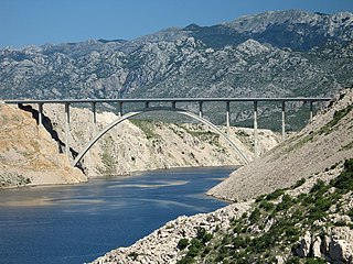
Maslenica Bridge is a 377.6 m (1,239 ft) long reinforced concrete arch bridge spanning the Novsko Ždrilo strait of the Adriatic Sea, north of Zadar, Croatia, carrying the Croatian A1 motorway. It is located between the Rovanjske and Posedarje interchanges of the A1 motorway.

<span class="mw-page-title-main">Surtees Bridge</span> Bridge over the River Tees in Northern England

The Surtees Bridge is a road bridge carrying the A66(T) road east west across the River Tees near Thornaby-on-Tees in the borough of Stockton-on-Tees in the north east of England. The bridge is situated one kilometre upriver from Stockton town centre, just upriver of Surtees Rail Bridge – a rail bridge carrying the Tees Valley Line. Built at a cost of £14.3 million the bridge replaces an earlier Surtees Bridge (1981) that showed signs of distress resulting from excessive settlement.

<span class="mw-page-title-main">Nepean River railway bridge, Menangle</span> Bridge in New South Wales, Australia

The Nepean River railway bridge is a heritage-listed railway bridge that carries the Main Southern railway line across Menangle Road and the Nepean River located at the outer south-western Sydney settlement of Menangle in the Wollondilly Shire local government area of New South Wales, Australia. It was designed by John Whitton as the Engineer-in-Chief, of the New South Wales Government Railways and NSW Department of Public Works. The railway bridge was built in 1863 by Messers Peto, Brassey and Betts. It is also known as Menangle rail bridge over Nepean River and Menangle Railway Bridge. The property was added to the New South Wales State Heritage Register on 2 April 1999.

<span class="mw-page-title-main">Clackline Bridge</span> Road bridge in Clackline, Western Australia

Clackline Bridge is a road bridge in Clackline, Western Australia, 77 kilometres (48 mi) east of Perth in the Shire of Northam, that carried the Great Eastern Highway until 2008. It is the only bridge in Western Australia to have spanned both a waterway and railway, the Clackline Brook and the former Eastern Railway alignment. The mainly timber bridge has a unique curved and sloped design, due to the difficult topography and the route of the former railway. The bridge was designed in 1934 to replace two dangerous rail crossings and a rudimentary water crossing. Construction began in January 1935, and was completed relatively quickly, with the opening ceremony held in August 1935. The bridge has undergone various improvement and maintenance works since then, including widening by three metres (10 ft) in 1959–60, but remained a safety hazard, with increasing severity and numbers of accidents through the 1970s and 1980s. Planning for a highway bypass of Clackline and the Clackline Bridge began in the 1990s, and it was constructed between January 2007 and February 2008. The local community had been concerned that the historic bridge would be lost, but it remains in use as part of the local road network, and has been listed on both the Northam Municipal Heritage Inventory and the Heritage Council of Western Australia's Register of Heritage Places.

<span class="mw-page-title-main">Nipigon River Bridge</span> Bridge in Nipigon, Ontario

The Nipigon River Bridge is a cable-stayed bridge in Canada carrying Highway 11 and Highway 17, designated as part of the Trans-Canada Highway, across the Nipigon River near Nipigon, Ontario.

<span class="mw-page-title-main">Yowaka River bridge, Greigs Flat</span> Bridge in New South Wales, Australia

The Yowaka River bridge is a heritage-listed road bridge that carries the Princes Highway across the Yowaka River at Greigs Flat, New South Wales, Australia. It was built in 1936. The bridge is also known as the Yowaka Bridge near Eden. The bridge is owned by Transport for NSW. It was added to the New South Wales State Heritage Register on 20 June 2000.

References

  1. "The Orwell Bridge". National Highways. 20 May 2020. Retrieved 23 February 2023.
  2. IABSE
  3. IHT The Highway Engineer January 1983
  4. Shell Orwell
  5. Chenery, Roger (4 February 2005). "Road safety on the A14 around Ipswich". Highways Agency.
  6. "Freyssinet Bearing Replacement on A14 Orwell Bridge" (PDF). Archived from the original (PDF) on 16 August 2011. Retrieved 5 May 2011.
  7. "Ipswich/Suffolk: Summit to look at diversions when A14 and Orwell Bridge are forced to close". 28 February 2014.
  8. "Safety improvement work begins on Orwell Bridge". 12 October 2017.
  9. "Orwell Bridge in Suffolk closes for 10 hours due to wind". BBC News. 13 January 2020. Retrieved 12 August 2023.
  10. "A14 Orwell Bridge: New speed limit signs installed at Ipswich". BBC News. 31 March 2021. Retrieved 12 August 2023.
  11. Highways, National (11 January 2021). "Orwell Bridge new speed limits during high winds - National Highways". nationalhighways.co.uk. Retrieved 12 August 2023.
  12. "Newmarket to Felixstowe Corridor Study (Section 4.16)" (PDF). East of England Regional Assembly. Archived from the original (PDF) on 28 September 2007. Retrieved 19 June 2006.
  13. "Port of Felixstowe South Reconfiguration Evidence (Section 7.4)" (PDF). Planning Inspectorate. Retrieved 19 June 2006.
  14. 1 2 "A14 Orwell Bridge to stay open today as region deals with aftermath of Storm Doris". 24 February 2017.
  15. 1 2 "Orwell Bridge fully reopens after high winds closed A14 over the river and caused traffic disruption for thousands around Ipswich".
  16. "Recap after the Orwell Bridge was closed". East Anglian Daily Times. 1 December 2023. Retrieved 3 December 2023.
  17. "Storm Eunice traffic chaos as heavy winds and snow close roads and bridges across UK". inews.co.uk. 18 February 2022. Retrieved 18 February 2022.
  18. "Highways England on Twitter". Twitter. Retrieved 30 April 2019.
  19. "Highways England on Twitter". Twitter. Retrieved 20 March 2019.
  20. "Highways England on Twitter". Twitter. Retrieved 13 March 2019.
  21. "Highways England on Twitter". Twitter. Retrieved 29 November 2018.
  22. "Orwell Bridge CLOSED due to high winds". Ipswich Star. Retrieved 24 January 2018.
  23. Hirst, Andrew. "Will the A14, Orwell Bridge, close in Suffolk due to high winds? Suffolk police reopen the bridge". Ipswich Star. Retrieved 18 January 2018.
  24. Howlett, Adam. "A14 Orwell Bridge reopens before evening rush hour". Ipswich Star. Retrieved 5 January 2018.
  25. "A14 Orwell Bridge opens after being closed for 8 hours after fatal traffic collision". 20 October 2017.
  26. "Orwell Bridge in Suffolk re-opens".
  27. "Storm Katie wreaks havoc across the East".
  28. 1 2 3 4 5 6 7 "Orwell Bridge Closures". 21 December 2016.
  29. "Suffolk/Essex: Orwell Bridge due to re-open this morning following strong overnight winds".
  30. "Big storm: Orwell Bridge reopened in both directions as St Jude's storm begins to subside".
  31. No further details of this incident available from local news outlets such as East Anglian Daily Times