Related Research Articles


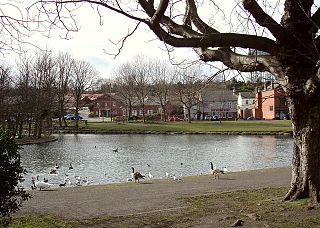
Pontefract is a historic market town in the Metropolitan Borough of Wakefield in West Yorkshire, England, east of Wakefield and south of Castleford. Historically part of the West Riding of Yorkshire, it is one of the towns in the City of Wakefield District and had a population of 30,881 at the 2011 Census. Pontefract's motto is Post mortem patris pro filio, Latin for "After the death of the father, support the son", a reference to the town's Royalist sympathies in the English Civil War.

The West Riding of Yorkshire is one of three historic subdivisions of Yorkshire, England. From 1889 to 1974 the administrative county County of York, West Riding (the area under the control of West Riding County Council), abbreviated County of York (WR), was based closely on the historic boundaries. The lieutenancy at that time included the City of York and as such was named West Riding of the County of York and the County of the City of York.
Askern is a town and civil parish within the City of Doncaster, in South Yorkshire, England. It is on the A19 road between Doncaster and Selby. Historically part of the West Riding of Yorkshire, it had a population of 5,570 at the 2011 Census. Askern was also known in for its Greyhound Stadium, which closed in 2022.

Selby District was a local government district of North Yorkshire, England, from 1974 to 2023. Its council was based in the town of Selby. The district had a population of 83,449 at the 2011 Census. The southernmost district of North Yorkshire, it bordered the City of York unitary authority, the Borough of Harrogate in North Yorkshire, the City of Leeds and City of Wakefield districts in West Yorkshire, the City of Doncaster in South Yorkshire, and the ceremonial county of the East Riding of Yorkshire.

Wakefield, commonly known as the City of Wakefield, is a local government district with the status of a city and metropolitan borough in West Yorkshire, England. Wakefield, the largest settlement, is the administrative centre of the district. The population of the City of Wakefield at the 2011 Census was 325,837. The district includes the Five Towns of Castleford, Featherstone, Knottingley, Normanton and Pontefract. Other towns include Hemsworth, Horbury, Ossett, South Elmsall and South Kirkby. The city and district are governed by Wakefield Council from the County Hall.
Eggborough is a village and civil parish, in the Selby District of North Yorkshire, England, close to the county borders with South Yorkshire, West Yorkshire and the East Riding, effectively making it the meeting point for all sides of Yorkshire.

Beal is a village and civil parish in North Yorkshire, England. It is situated on the River Aire, 3.5 miles (6 km) north-east of Knottingley, 8 miles (13 km) south-west of Selby, and 21 miles (34 km) south of York. The parish includes the village of Kellingley, and borders the City of Wakefield in West Yorkshire. At the 2001 census it had a population of 720, increasing to 738 at the 2011 census.
Hemsworth was, from 1894 to 1974, a rural district in the West Riding of Yorkshire, England.

Osgoldcross was a wapentake of the West Riding of Yorkshire, England. It included the parishes of Adlingfleet, Badsworth, Burghwallis, Campsall, Castleford, Darrington, Kellington, South Kirkby, Owston, Pontefract, Whitgift, Womersley, Ferry Fryston and parts of Featherstone, Snaith and Wragby.

Darrington is a small village and civil parish in the City of Wakefield in West Yorkshire, England, 3 miles (4.8 km) from Pontefract and 25 miles (40 km) from the city of York. The village is split in two by the busy A1 trunk road which runs from London to Scotland. The 2011 census population was 1,403.

Wentbridge is a small village in the City of Wakefield district of West Yorkshire, England. It lies around 3 miles (5 km) southeast of its nearest town of size, Pontefract, close to the A1 road.
East Hardwick is a village and civil parish in the City of Wakefield in West Yorkshire, England. It has a population of 191, reducing to 173 at the 2011 Census. Until 1974 it was part of Osgoldcross Rural District.

Hensall is a village and civil parish in the English county of North Yorkshire.
Heck is a civil parish in the English county of North Yorkshire. The population of this civil parish at the census 2011 was 201, a slight drop on the 2001 census figure of 209.

The Selby–Goole line was a standard gauge branch line connecting Selby and Goole, built in 1910 by the North Eastern Railway. The line closed in the 1960s as part of the Beeching cuts.

The Municipal Borough of Castleford was a local government district in the West Riding of Yorkshire from 1955 to 1974 around the town of Castleford, covering Airedale, New Fryston, Whitwood, Cutsyke, Glasshoughton and Whitwood. The Castleford Urban District administered the town from 1894 to 1955.

Wakefield Council, formally the City of Wakefield Metropolitan District Council, is the local authority of the City of Wakefield in West Yorkshire, England. Wakefield is a metropolitan borough with city status. The council and provides a full range of local government services including Council Tax billing, libraries, social services, town planning, waste collection and disposal, and it is a local education authority. Wakefield is divided into 21 wards, electing 63 councillors. A third of the council is elected for three of every four years.