| Whitley | |
|---|---|
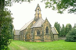 All Saints Whitley | |
 Whitley Location within North Yorkshire | |
| Population | 1,021 (2011 census) [1] |
| OS grid reference | SE561212 |
| Unitary authority | |
| Ceremonial county | |
| Region | |
| Country | England |
| Sovereign state | United Kingdom |
| Post town | GOOLE |
| Postcode district | DN14 |
| Dialling code | 01977 |
| Police | North Yorkshire |
| Fire | North Yorkshire |
| Ambulance | Yorkshire |
Whitley is a village in North Yorkshire, England, close to the Aire and Calder Navigation and the M62 motorway. The population of the village at the 2001 census was recorded as being 574, [2] which had risen to 1,021 by the time of the 2011 census. [1] In 2015, North Yorkshire County Council estimated the population to have risen again to 1,110. [3] It was historically part of the West Riding of Yorkshire until 1974. [4] From 1974 to 2023 it was part of the district of Selby, it is now administered by the unitary North Yorkshire Council.