Oshawa Executive Airport

Last updated
Oshawa Executive Airport

Toronto/Oshawa Executive Airport
Oshawa Executive Airport.jpg
YOO Main Terminal 2018.jpg
Summary
Airport typePublic
Owner/OperatorCity of Oshawa [1]
ServesGreater Toronto and Durham Region
Location Oshawa, Ontario
Time zone EST (UTC−05:00)
  Summer (DST)EDT (UTC−04:00)
Elevation  AMSL 460 ft / 140 m
Coordinates 43°55′22″N078°53′47″W / 43.92278°N 78.89639°W / 43.92278; -78.89639
Website www.oshawa.ca
Map
Canada Southern Ontario location map 2.png
Airplane silhouette.svg
CYOO
Location in Ontario
Canada Ontario location map 2.svg
Airplane silhouette.svg
CYOO
CYOO (Ontario)
Canada location map 2.svg
Airplane silhouette.svg
CYOO
CYOO (Canada)
Runways
Direction LengthSurface
ftm
05/232,654809Asphalt
12/304,2501,295Asphalt
Statistics (2019)
Aircraft movements89,805

Oshawa Executive Airport( IATA : YOO, ICAO : CYOO) is a municipal airport adjacent to the north end of the city of Oshawa, Ontario, Canada. [5] It is the busiest general aviation airport without scheduled airline service in the Greater Toronto Area by aircraft movements and one of the busiest general aviation only airports in Canada. It includes two paved runways and instrument approaches.

Contents

From 2002 to 2008, Oshawa hosted the annual Canadian Aviation Expo, Canada's largest annual aviation event, before the expo moved to John C. Munro Hamilton International Airport in 2009. Oshawa Airport now hosts the Girls Take Flight event that takes place every spring. [6]

The airport is classified as an airport of entry by Nav Canada and is staffed on call by the Canada Border Services Agency. CBSA officers at this airport can handle aircraft with no more than 50 passengers. [2] The officers also provided weekday call out for general aviation arriving from outside Canada to Buttonville Municipal Airport in Markham, Ontario before that airport was closed in 2023. [7]

History

The airport opened in June 1941 under the British Commonwealth Air Training Plan as No. 20 Elementary Flying Training School RCAF Station Oshawa. Student flyers used Tiger Moth aircraft and were trained by civilian instructors from the Oshawa, Kingston, and Brant-Norfolk flying clubs. A relief landing field was located at Whitby. [8] The school closed in December 1944 and the airfield was turned over to the Department of Transport. The then-Town of Oshawa took over the facility in 1947. [9]

The planned construction of a Pickering Airport, between Oshawa and Toronto, raised questions about the future of the Oshawa airport. [10] In 2018 the mayor of nearby Pickering made the construction of a new modern jet airport in Pickering a key part of his platform, winning a landslide victory. Local media continues to report that there remains strong opposition to the construction of the Pickering Airport by some residents. This project was initiated in 1972, then placed on hold in 1975. The Greater Toronto Airports Authority (GTAA) is not related to Oshawa Airport in any way and as of 2011 has no further role in Pickering Airports development.[ citation needed ]

In 2008 the City of Oshawa adopted the Oshawa Municipal Airport Business Plan which includes a commitment to operate the airport for a minimum of 25 years. Dozens of upgrades completed by 2010 include construction of new Taxiway "C", Phase 1 of Hangarminium Complex, cardlock fuel facility, and Automated Weather Observation System.

On July 11, 2011, Ornge Air Medivac announced that it would open a 24-hour base to help cut the airlift response time to Toronto hospitals. This plan was cancelled in 2013.

In 2011–2012, local politicians and the contracted airport management were endeavouring to expand the main runway from 4,000 to 5,000 ft (1,200 to 1,500 m) to acquire additional and larger corporate traffic. This was met with much opposition, as the existing surrounding community is already in close proximity of the runway and the flight paths. The surrounding community asserts that increasing activity at an airport closely nested among residential communities is irresponsible. The surrounding community is also concerned that they are not being represented appropriately by the local standing committees. The proposal to expand was delayed at a public meeting on December 5, 2011, as there was not enough room in the Oshawa Council Chambers to accommodate all of the public that showed up in opposition. A new meeting date was to be set sometime in January 2012. After the meeting and great opposition from the general public, it was decided in August 2012 that the expansion project would be cancelled. There has been no revival of the expansion plan since.

New Nav Canada control tower in Oshawa YOO Control Tower.jpg
New Nav Canada control tower in Oshawa

In 2016, the City of Oshawa approved a $6 million plan to reconstruct runway 12-30 that would involve an estimated four-week closure of the airport to all fixed-wing aircraft. The construction started on September 5, 2017, and the runway reopened on October 10, 2017. The airport added new LED edge lights and PAPIs on runway 12–30 to improve night and low advisability conditions. During this time Nav Canada approved and started construction on a new control tower to the northwest of the original tower that was built over 50 years ago. The new tower was estimated to cost $9 million and opened for use in June 2018. [11]

On November 1, 2018, Nav Canada announced the closure of the nearby Buttonville Municipal Airport's control tower, re-built in 2006, and weather office effective January 3, 2019. The terminal area forecast station was installed at Oshawa Executive and scheduled to be operational on the same day that Buttonville shut down its facility. [12]

Facilities

Oshawa Executive Airport is managed and maintained by Total Aviation & Airport Solutions under contract from the operator, the City of Oshawa. [1] TAAS also operate and control the fuel pumps on the North Apron.

Commercial radio stations CKDO and CKGE-FM, licensed to Oshawa, and CJKX, licensed to Ajax, operate from studios on the Oshawa Airport grounds. These organizations operate on former airport land at the entrances to the airport on Taunton Road: Mandarin Chinese Buffet restaurant; Taunton Health Centre, part of the largest, multi-specialty medical group practice in Canada, including Urgent Care, Laboratory, Pharmacy and a dental office aptly named, The Airport Dental Centre; Airport Self Storage Ltd., with ten buildings on six acres; National Defence, The Ontario Regiment, Royal Canadian Armoured Corps, Oshawa Airport Armoury; and the Durham Children's Aid Society.

A live fire training simulator opened south of the control tower in October 2009. It is a partnership between Durham College and the fire departments of Clarington, Oshawa and Whitby.

Fixed-base operator

ALCI Aviation Basler BT-67 at Enterprise Apron. Commonly used at Oshawa Airport. BT67 C-GOOU.jpg
ALCI Aviation Basler BT-67 at Enterprise Apron. Commonly used at Oshawa Airport.

Enterprise Airlines is currently the only full-service FBO at the airport. Enterprise officially opened its doors in 1994 at the original location on the south end of the field next to the old control tower. Enterprise moved to the northwest corner of the field in 2000. The FBO stays open 24 hours per day, 7 days a week, operating for medevac services and the police air support unit.

Tenants

Emergency services

See also

Related Research Articles

<span class="mw-page-title-main">London International Airport</span> Airport in Ontario, Canada

The London International Airport is an international airport located in London, Ontario, Canada. It is located 5 nautical miles northeast of the city of London, Ontario and is classified as an airport of entry by Nav Canada. In 2011, the airport was listed as the 20th busiest airport in Canada in terms of aircraft movements with 94,747 travels. The airport posted a record 683,000 travelers in 2019 and 340,000 passengers in 2023. It provides services for cargo airlines and year-round flights with Air Canada Express and WestJet.

<span class="mw-page-title-main">Billy Bishop Toronto City Airport</span> Airport in Toronto Islands, Ontario, Canada

Billy Bishop Toronto City Airport is a regional airport located on the Toronto Islands in Toronto, Ontario, Canada. It is often referred to as Toronto Island Airport and was previously known as Port George VI Island Airport and Toronto City Centre Airport. The airport's name honours Billy Bishop, the Canadian World War I flying ace and World War II Air Marshal. It is used by civil aviation, air ambulances, and regional airlines using turboprop planes. In 2022, it was ranked Canada's ninth-busiest airport.

<span class="mw-page-title-main">Thunder Bay International Airport</span> Airport in Thunder Bay, Ontario, Canada

Thunder Bay Airport is an airport in the city of Thunder Bay, Ontario, Canada. With 108,130 aircraft movements in 2012, it was the fourth busiest airport in Ontario and the 16th busiest airport in Canada. During the same year, more than 761,000 passengers went through the airport.

<span class="mw-page-title-main">Boundary Bay Airport</span> Airport in Delta, British Columbia

Boundary Bay Airport or Vancouver/Boundary Bay Airport is located beside Boundary Bay and 2.5 nautical miles east of Ladner in Delta, British Columbia, Canada, 8.5 NM south southeast of Vancouver and close to the Point Roberts-Boundary Bay border crossing. The airport, which opened on July 11, 1983, serves mostly general aviation and includes facilities for aircraft maintenance, flight training and parking. In 2020 and 2021, Boundary Bay airport was ranked as the busiest airport in Canada by aircraft movements.

<span class="mw-page-title-main">Buttonville Municipal Airport</span> Airport in Markham, Ontario

Buttonville Municipal Airport or Toronto/Buttonville Municipal Airport was a medium-sized airport in the neighbourhood of Buttonville in Markham, Ontario, Canada, 29 km (18 mi) north of Downtown Toronto, which closed in November, 2023. It was operated by Torontair. Due to its location within Toronto's suburbs, there were several strict noise-reduction procedures for aircraft using the airport, which was open and staffed 24 hours a day, 365 days a year. In 2014, Buttonville was Canada's 20th busiest airport by aircraft movements. There was also a weather station located at the airport, which was still operational on the site but closed along with the airport.

<span class="mw-page-title-main">Pickering Airport Lands</span> Proposed second airport to serve Toronto, Ontario, Canada

The Pickering Airport Lands are parcels of lands owned by the Government of Canada located in York Region and Durham Region in the Greater Toronto Area of Ontario. The lands, totaling approximately 18,600 acres and located approximately 56 kilometres east of Downtown Toronto, were expropriated in 1972 by the federal government intending for a second international airport to serve the city of Toronto, its metropolitan area, and the surrounding Golden Horseshoe region. Since then, the federal government has leased the lands to private tenants and allocated more than half to form the Rouge National Urban Park.

<span class="mw-page-title-main">Region of Waterloo International Airport</span> International airport serving the Regional Municipality of Waterloo

Region of Waterloo International Airport or Kitchener/Waterloo Airport is an international airport serving the Regional Municipality of Waterloo in Woolwich, Ontario, Canada, west of Toronto. It has year round daily flights to Edmonton, Vancouver, Victoria, Winnipeg, Calgary, Orlando, Halifax, Fort Lauderdale and Kelowna through Flair Airlines and WestJet. It also has seasonal flights to Cancun through Sunwing Airlines and Flair Airlines. In 2022, the airport ranked seventh-busiest in Canada by total aircraft movements and twentieth-busiest by passenger traffic.

<span class="mw-page-title-main">North Bay/Jack Garland Airport</span> Airport in Hornell Heights

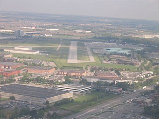
North Bay Airport or North Bay/Jack Garland Airport in North Bay, Ontario, Canada is located at Hornell Heights, 4 nautical miles north-northeast of the city. It is located adjacent to Canadian Forces Base North Bay, operational since 1951, the operational control centre for Canadian operations of the North American Aerospace Defense Command.

<span class="mw-page-title-main">Peterborough Airport</span> Airport in Peterborough, Ontario, Canada

Peterborough Airport is located 3 nautical miles south-southwest of the city of Peterborough, Ontario, Canada. It includes a main 7,000 by 100 ft asphalt runway oriented east-west, and a smaller 2,000 by 49 ft paved (2014) runway oriented northwest-southeast. A new terminal building was built in 2011. Aircraft completions company Flying Colours Corp. is the largest tenant at the airport.

<span class="mw-page-title-main">John C. Munro Hamilton International Airport</span> Airport in Hamilton, Ontario, Canada

John C. Munro Hamilton International Airport, also referred to as Toronto–Hamilton International Airport or simply Hamilton Airport, is an international airport in Hamilton, Ontario, Canada. The airport is part of the neighbourhood of Mount Hope, 6 nautical miles southwest of Downtown Hamilton and 64 km (40 mi) southwest of Toronto. The airport serves the city of Hamilton and adjacent areas of Southern Ontario, including the Greater Toronto Area. It is the closest relief airport for Toronto Pearson International Airport capable of handling jet aircraft. The airport is named after John Carr Munro, a longtime Member of Parliament for Hamilton East.

<span class="mw-page-title-main">Morristown Municipal Airport</span> Airport in Whippany, Morris County

Morristown Airport is in Morris County, New Jersey, United States, three miles east of downtown Morristown and 40 miles west of Manhattan, New York City. Operated by DM AIRPORTS, LTD, it is in the Whippany section of Hanover. The National Plan of Integrated Airport Systems for 2011–2015 called it a general aviation reliever airport.

<span class="mw-page-title-main">St. John's International Airport</span> Airport in Newfoundland and Labrador, Canada

St. John's International Airport is in Newfoundland and Labrador, Canada. It is located 3 nautical miles northwest of St. John's, Newfoundland and Labrador and serves the St. John's metropolitan area and the Avalon Peninsula. The airport is part of the National Airports System, and is operated by St. John's International Airport Authority Inc.

<span class="mw-page-title-main">Brandon Municipal Airport</span> Airport in Manitoba, Canada

Brandon Municipal Airport is an airport located 1.6 kilometres (1 mi) north of Brandon, Manitoba, Canada. It serves the City of Brandon, the Westman and Parkland regions of Manitoba, and eastern Saskatchewan. Brandon Municipal Airport is classified as an airport of entry by Nav Canada and is staffed by the Canada Border Services Agency (CBSA) on a call-out basis from the International Peace Garden Border Crossing.

<span class="mw-page-title-main">JA Douglas McCurdy Sydney Airport</span> Airport in Reserve Mines, Nova Scotia

JA Douglas McCurdy Sydney Airport is a regional airport located in Reserve Mines in the Canadian province of Nova Scotia. The airport serves the Cape Breton Regional Municipality (CBRM) and the surrounding areas of Cape Breton Island. McCurdy Sydney Airport has the distinction of being the oldest public airport in Nova Scotia, first licensed on August 3, 1929.

<span class="mw-page-title-main">Brantford Airport</span> Airport in Brantford, Ontario

Brantford Airport, also known as Brantford Municipal Airport, is a registered aerodrome located 4 nautical miles west southwest of the City of Brantford, in the county of Brant, Ontario, Canada.

<span class="mw-page-title-main">Westfield-Barnes Regional Airport</span> Airport

Westfield-Barnes Regional Airport is a joint civil-military airport in Hampden County, Massachusetts, three miles (6 km) north of Westfield and northwest of Springfield. It was formerly Barnes Municipal Airport; the National Plan of Integrated Airport Systems for 2011–2015 categorized it as a general aviation facility. Westfield-Barnes is one of Massachusetts' largest airports with a strong flight training, general aviation, and military presence. It is also known as Barnes Air National Guard Base.

Red Deer Regional Airport is located 6 nautical miles south southwest of Red Deer, Alberta, Canada. The airport serves Charter and General Aviation.

<span class="mw-page-title-main">Kingston Norman Rogers Airport</span> Airport in Kingston, Ontario

Kingston Norman Rogers Airport or YGK Airport, also known as Kingston Airport, is the main airport serving Kingston, Ontario and its metropolitan area. The airport is named after former MP Norman McLeod Rogers, Minister of Labour and then National Defence in Prime Minister William Lyon Mackenzie King's cabinet. Located 4.3 nautical miles west of downtown Kingston, Ontario, in the west end of the city, it is the largest airport in the region, in 2019 it was reported that 70,000 people travel through the airport each year.

Toronto Area Control Center is one of seven area control centers in Canada operated by Nav Canada. The Toronto Area Control Centre is based near Toronto Pearson International Airport in Mississauga, Ontario.

<span class="mw-page-title-main">Markham Airport</span> Airport in Markham, Ontario

Markham Airport or Toronto/Markham Airport is a private aerodrome operating 2.6 nautical miles north of Markham, Ontario, Canada near Toronto.

References

  1. 1 2 "About the Oshawa Executive Airport".
  2. 1 2 Canada Flight Supplement. Effective 0901Z 16 July 2020 to 0901Z 10 September 2020.
  3. Synoptic/Metstat Station Information
  4. Government of Canada, Statistics Canada (November 24, 2022). "Add/Remove data - Aircraft movements, by class of operation and peak hour and peak day of movements, for airports with NAV CANADA towers, monthly, inactive". www150.statcan.gc.ca.
  5. Foley, Isabelle (October 9, 2015). "Introducing the Oshawa Executive Airport".
  6. "Girls Take Flight". www.girlstakeflight.ca.
  7. Larkin, F.K. (Ted) (2023-11-25). "Toronto Buttonville YKZ Municipal Airport in Markham now Closed". Canadian Aviation News. Retrieved 2024-01-05.
  8. Hatch, F. J. (1983). The Aerodrome of Democracy: Canada and the British Commonwealth Air Training Plan, 1939-1945. Ottawa: Directorate of History, Department of National Defence. ISBN   0660114437.
  9. Heritage Oshawa. "No 10 Building - Oshawa Airport (No 420 Wing R.C.A.F. Association) 1000 Stevenson Road North Oshawa". Archived from the original on 17 August 2007. Retrieved 12 March 2015.
  10. "Exploring the intertwined future of Oshawa, Buttonville and Pickering Airports". Friends of Pickering Airport. November 26, 2018. Retrieved January 25, 2019.
  11. "Runway open for business". The Oshawa Express. November 1, 2017.
  12. "Oshawa Executive Airport and NAV Canada announce changes to weather monitoring". City of Oshawa. Retrieved January 25, 2019.
  13. "Airborne Sensing". airsensing.com.
  14. "Canadian Flight Academy | Toronto Airways Inc". Canadian Flight Academy.
  15. "COPA Flight 70". www.copa70.com.
  16. "Enterprise Aviation Group". February 1, 2017.
  17. "Avfuel - Global Supplier of Aviation Fuel And Services".
  18. "Home | Teledyne Geospatial". www.teledyneoptech.com.
  19. R.C.A.F. 420 Wing, Royal Canadian Air Force Association
  20. "Ryanterminal.com". www.ryanterminal.com.
  21. "SkyWay Cafe & Catering, Brantford Breakfast Restaurant, Ontario". skywaycafe.
  22. "Aviation Supplies". September 24, 2002. Archived from the original on 2002-09-24.

Commons-logo.svg Media related to Oshawa Airport at Wikimedia Commons