Related Research Articles

Eswatini, officially the Kingdom of Eswatini and formerly officially entitled in English as Swaziland, is a landlocked country in Southern Africa. It is bordered by Mozambique to its northeast and South Africa to its north, west, south and southeast. At no more than 200 kilometres (120 mi) north to south and 130 kilometres (81 mi) east to west, Eswatini is one of the smallest countries in Africa; despite this, its climate and topography are diverse, ranging from a cool and mountainous highveld to a hot and dry lowveld.
Public transport is the main means of transportation in Eswatini. Car ownership is low, at 32 cars per 1,000 people. The National Road Network has 1500 km of main roads and 2270 km of district roads.
The Umbutfo Eswatini Defence Force (UEDF) is the official armed national military of the Southern African Kingdom of Eswatini (Swaziland). It is used primarily during domestic protests, with some border and customs duties; the force has never been involved in a foreign conflict. The army has struggled with high rates of HIV infection. Since measures were put in place the rate is dropping.
Artifacts indicating human activity dating back to the early Stone Age have been found in the Kingdom of Eswatini. Prehistoric rock art paintings date from c. 25,000 B.C. and continuing up to the 19th century can be found in various places around the country. The earliest known inhabitants of the region were Khoisan hunter-gatherers. Later, the population became predominantly Nguni during and after the great Bantu migrations. People speaking languages ancestral to the current Sotho and Nguni languages began settling no later than the 11th century. The country now derives its name from a later king named Mswati II. Ngwane, named for Ngwane III, is an alternative name for Swaziland the surname of whose royal house remains Nkhosi Dlamini. Nkhosi literally means "king". Mswati II was the greatest of the fighting kings of Eswatini, and he greatly extended the area of the country to twice its current size. The people of Eswatini largely belong to a number of clans that can be categorized as Emakhandzambili, Bemdzabu, and Emafikamuva, depending on when and how they settled in Eswatini.
Mbabane is a city in Eswatini, and is one of the two capitals, serving as the executive capital.

Sani Pass is a mountain pass located in the West of KwaZulu-Natal, South Africa on the road between Underberg, KwaZulu-Natal and Mokhotlong, Lesotho.
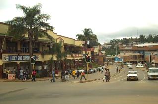
Lubuli is a town in southeastern Eswatini (Swaziland). It is located close to the South African border just to the northwest of the town of Nsoko on the road between there and Maloma.

Hlane Royal National Park is a national park in Eswatini, roughly 67 km northeast of Manzini along the MR3 road. Prior to the park being public, it was a private royal hunting ground. Hlane, meaning 'wilderness', was named by King Sobhuza II. It is now held in trust for the Nation by His Majesty King Mswati III, and is managed by Big Game Parks, a privately owned body.

Severe Tropical Storm Domoina in 1984 caused 100 year floods in South Africa and record rainfall in Swaziland. The fourth named storm of the season, Domoina developed on January 16 off the northeast coast of Madagascar. With a ridge to the north, the storm tracked generally westward and later southwestward. On January 21, Domoina struck eastern Madagascar, the third storm in six weeks to affect the nation; collectively, the storms caused 42 deaths and $25 million in damage (1984 USD). After crossing the country, Domoina strengthened in the Mozambique Channel to peak 10-minute sustained winds of 95 km/h (60 mph). On January 28, the storm made landfall in southern Mozambique, and slowly weakened over land. Domoina crossed into Swaziland and later eastern South Africa before dissipating on February 2.
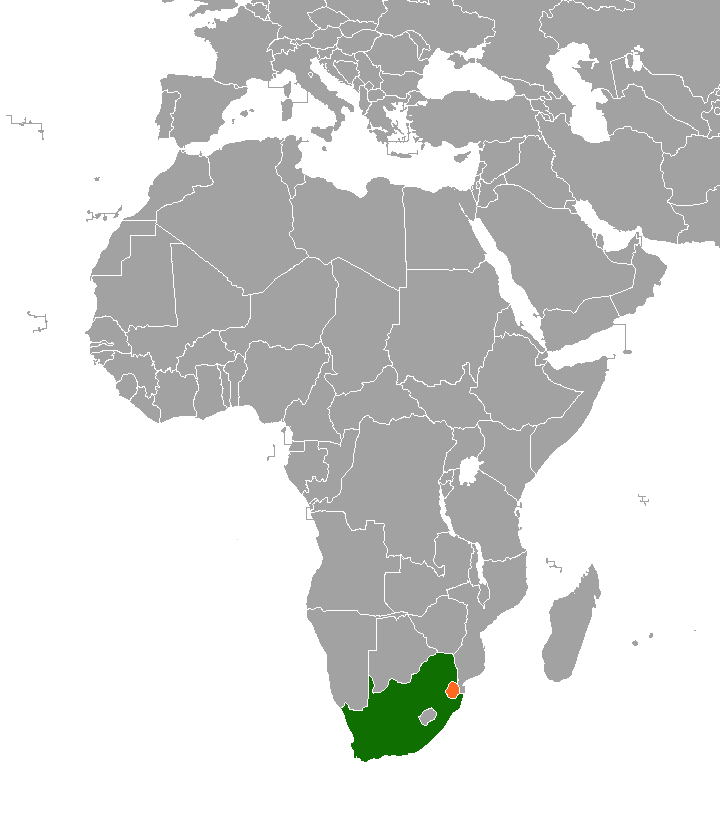
Eswatini–South Africa relations refers to the current and historical relationship between Eswatini and South Africa. South Africa surrounds Eswatini on the north, west and south. The two states share strong historical and cultural ties. Mutual High Commissions were established in Pretoria and Mbabane at the end of the apartheid era in 1994. Eswatini's High Commission in Pretoria is also cross-accredited to Botswana, Lesotho, Namibia, Zambia and Zimbabwe.

Tourism in Eswatini is a successful industry. Most of the tourists who visit Eswatini arrive by road from South Africa. Eswatini's tourism industry developed during the apartheid era in South Africa and this shaped many of its distinctive attractions. Since the end of apartheid, Eswatini has emphasized its traditional culture as a tourist attraction.
Jeppes Reef, officially Magogeni ,is a small rural town on the R40 road in Ehlanzeni District Municipality in the Mpumalanga province of South Africa, 25 kilometres (16 mi) south-southeast of Kaapmuiden, and just over 2 kilometres (1.2 mi) from the border with Eswatini.
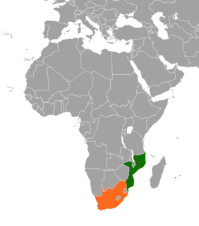
The border between Mozambique and South Africa is divided into two segments, separated by the kingdom of Eswatini. The northern segment, which is 410 kilometres (255 mi) long, runs north–south along the Lebombo Mountains from Zimbabwe to Swaziland. The southern segment, which is 81 kilometres (50 mi) long, runs east–west across Maputaland from Swaziland to the Indian Ocean.
The border between Eswatini and South Africa is 430 kilometres (267 mi) long; South Africa surrounds Eswatini to the north, west, south and southeast, with Mozambique bordering it on the northeast.
The 2015 Africa U-23 Cup of Nations qualification was a men's under-23 football competition which decided the participating teams of the 2015 Africa U-23 Cup of Nations. Players born on or after 1 January 1993 were eligible to compete in the tournament.

Piet Retief Commando was a light infantry regiment of the South African Army. It formed part of the South African Army Infantry Formation as well as the South African Territorial Reserve.
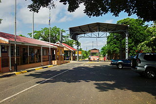
Nerston on the R65 road in Mpumalanga is a border post between South Africa and Eswatini. The Eswatini side of the border is known as Sandlane, and the road leading into Eswatini is the MR19. The border is open between 08:00 and 18:00
Josefsdal on the R40 road in Mpumalanga is a border crossing between South Africa and Swaziland. The Swaziland side of the border post is known as Bulembu. The border is open between 08:00 and 16:00

111 Battalion was a motorised infantry unit of the South African Army.

Matata is a town in Eswatini.
References
- ↑ "South African Ports of entry". Archived from the original on 2015-08-28. Retrieved 2015-08-22.