Otavi

Last updated
Otavi
Otjitavi
Town
Otavi (2018).jpg
Aerial view of Otavi (2018)
Wappen Otavi - Namibia.png
Nickname: 
otavio
Motto: 
Volhard en Oorwin
Namibia location map.svg
Red pog.svg
Otavi
Location in Namibia
Coordinates: 19°39′S17°20′E / 19.650°S 17.333°E / -19.650; 17.333
CountryFlag of Namibia.svg  Namibia
Region Otjozondjupa Region
Constituency Otavi Constituency
Area
  Total165 sq mi (428 km2)
Population
 (2023 census) [1] [2]
  Total10,756
  Density65/sq mi (25/km2)
Time zone UTC+2 (SAST)
Climate BSh

Otavi is a town with 10,000 inhabitants in the Otjozondjupa Region of Namibia. Situated 360 km north of Windhoek, it is the district capital of the Otavi electoral constituency.

Contents

Geography

The towns of Otavi, Tsumeb (to the north) and Grootfontein (to the northeast) define an area known as the "Otavi Triangle", also known as the Otavi Mountainland. This geographical region is sometimes referred to as the "Golden Triangle", or as the "maize Triangle", owing to the cultivation of maize in the area. [3] The three towns that define the triangle are roughly 60 km from each other.

Most of the area is dolomitic (Precambrian) and the district was renowned for its mineral wealth in the past. Most of the deposits have now been exhausted. Elefantenberg (elephant mountain), a mountain 1,624 meters above sea level, is located about 7 km south of Otavi. [4]

Economy and infrastructure

Much of the town's economy relies on the two grocery stores, a mill, two banks, two gas stations, and many surrounding game/cattle farms, as well as a handful of other small business. The owners of most of these businesses are Afrikaners (white Africans or Boer, ultimately Dutch in heritage) or Germans.

Due to financial mismanagement, Otavi lost its town status in 2004 and was downgraded to "village". After revenue picked up again, town status was reinstated in November 2010. With the foundation of the Ohorongo Cement factory and the Otjikoto mine, operated by B2Gold , business and employment rate has been recovering. [5] A steel manufacturing plant is also being developed. The project will cost $201 million and it's expected to produce 100,000 tons of steel. [6]

Transport

Elefantenberg south of Otavi next to the B1 (2014) Elefantenberg, Namibia (2014).jpg
Elefantenberg south of Otavi next to the B1 (2014)

Otavi is a railway junction where the line from Windhoek to Oshikango branches off the line to Grootfontein. The town is served by the Otavi railway station.

Otavi is situated next to the B1 - the longest National Road, running the length of Namibia - about 370 km from the capital, Windhoek.

History

On July 1, 1915, the German Army was defeated at Otavi by South African troops; on June 9 they surrendered nearby and signed the Khorab Peace Treaty. A public monument to this event was erected in 1973 outside of Otavi.

During the South African Border War SWASpes, the 1 SWA Specialist Unit was based here, moving from Oshivelo in 1979. The unit consisted of horse mounted troops, dog trackers, human trackers and motorcycle units to hunt insurgents.[ citation needed ]

Politics

Otavi is governed by a town council that currently has seven seats. [7]

The 2015 local authority election was won by SWAPO which gained six seats and 957 votes. The remaining seat went to the Democratic Turnhalle Alliance (DTA) which gained 79 votes. [8] SWAPO also won the 2020 local authority election. It obtained 1,092 votes and gained five seats. One seat each went to the Independent Patriots for Change (IPC, an opposition party formed in August 2020) and to the Landless People's Movement (LPM, an opposition party formed in 2016) with 260 and 167 votes, respectively. [9]

Education

Otavi has three schools, namely: Otavi Primary School, Khorab Senior Secondary School and the Deutsche Privatschule Otavi-Namibia. Previously the German Regierungsschule Otavi (Government School Otavi) was situated in Otavi. [10]

See also

Related Research Articles

<span class="mw-page-title-main">Otjozondjupa Region</span> Region in Namibia

Otjozondjupa is one of the fourteen regions of Namibia. Its capital is Otjiwarongo. The region further contains the municipalities of Okahandja and Grootfontein and the towns Okakarara and Otavi. As of 2020, Otjozondjupa had 97,945 registered voters.

<span class="mw-page-title-main">Oranjemund</span> Town in ǁKaras Region, Namibia

Oranjemund is a diamond mining town of 4,000 inhabitants situated in the ǁKaras Region of the extreme southwest of Namibia, on the northern bank of the Orange River mouth at the border to South Africa.

<span class="mw-page-title-main">Swakopmund</span> City in Erongo, Namibia

Swakopmund is a city on the coast of western Namibia, 352 km (219 mi) west of the Namibian capital Windhoek via the B2 main road. It is the capital of the Erongo administrative district. As of 2011, the town had 44,725 inhabitants and 196 km2 (76 sq mi) of land. In 2023, the population had increased to 75,921 people.

<span class="mw-page-title-main">Gobabis</span> City in Omaheke Region, Namibia

Gobabis is a town in eastern Namibia. It is the regional capital of the Omaheke Region, and the district capital of the Gobabis electoral constituency. Gobabis is situated 200 km (120 mi) down the B6 motorway from Windhoek to Botswana. The town is 113 km (70 mi) from the Buitepos border post with Botswana, and serves as an important link to South Africa on the tarred Trans-Kalahari Highway. Gobabis is in the heart of the cattle farming area. In fact Gobabis is so proud of its cattle farming that a statue of a large Brahman bull with the inscription "Cattle Country" greets visitors to the town. Gobabis also has its own local airport.

<span class="mw-page-title-main">Grootfontein</span> City in the Otjozondjupa Region of central Namibia

Grootfontein is a town with 26,839 inhabitants in the Otjozondjupa Region of central Namibia. It is one of the three towns in the Otavi Triangle, situated on the B8 national road that leads from Otavi to the Caprivi Strip.

<span class="mw-page-title-main">Keetmanshoop</span> City in ǁKaras Region, Namibia

Keetmanshoop is a town in the ǁKaras Region of southern Namibia, lying on the Trans-Namib Railway from Windhoek to Upington in South Africa. It is named after Johann Keetman, a German industrialist and benefactor of the city.

<span class="mw-page-title-main">Karibib</span> Town in Erongo Region, Namibia

Karibib is a town in the Erongo Region of western Namibia. It has 3,800 inhabitants and owns 97 square kilometres (37 sq mi) of town land. Karibib is the district capital of the Karibib electoral constituency. It is situated on the Khan River, halfway between Windhoek and Swakopmund on the B2, the main road between Walvis Bay and Johannesburg. The town is known for its aragonite marble quarries and the Navachab Gold Mine.

<span class="mw-page-title-main">Tsumeb</span> City in Oshikoto Region, Namibia

Tsumeb is a city of around 35,000 inhabitants and the largest town in the Oshikoto region in northern Namibia. Tsumeb is known as the "gateway to the north" of Namibia. It is the closest town to the Etosha National Park. Tsumeb used to be the regional capital of Oshikoto until 2008 when Omuthiya was proclaimed a town and the new capital. The area around Tsumeb forms its own electoral constituency and has a population of 44,113. The town is the site of a deep mine that in its heyday was known as "TCL", but has since been renamed the Ongopolo Mine.

<span class="mw-page-title-main">Rehoboth, Namibia</span> Town in Hardap Region, Namibia

Rehoboth is a town in central Namibia just north of the Tropic of Capricorn. Located 90 kilometres south of the Namibian capital Windhoek, Rehoboth lies on a high elevation plateau with several natural hot-water springs. It receives sparse mean annual rainfall of 240 millimetres (9.4 in), although in the 2010/2011 rainy season a record 731 millimetres (28.8 in) were measured. In 2005, it had a population of 21,378 later increased to 28,843 in 2011, according to the 2011 Namibian Population and Housing Census. In 2023, it had increased further to 40,788 people.

Okahandja is a city of 45,159 inhabitants in Otjozondjupa Region, central Namibia, and the district capital of the Okahandja electoral constituency. It is known as the Garden Town of Namibia. It is located 70 km north of Windhoek on the B1 road. It was founded around 1800, by two local groups, the Herero and the Nama.

<span class="mw-page-title-main">Otjiwarongo</span> City in Otjozondjupa Region, Namibia

Otjiwarongo is a city of 49,000 inhabitants in the Otjozondjupa Region of Namibia. It is the district capital of the Otjiwarongo electoral constituency and also the capital of Otjozondjupa.

<span class="mw-page-title-main">Mariental, Namibia</span> City in Hardap Region, Namibia

Mariental is a town of 10,000 inhabitants in south-central Namibia, lying on the B1 national road 232 kilometres (144 mi) north of Keetmanshoop and 274 kilometres (170 mi) southeast of Windhoek. It lies at an elevation of 1,090 metres (3,580 ft). Mariental is connected to the TransNamib railway line from Windhoek to Keetmanshoop. The town and the surrounding area are situated in a hot, arid region.

<span class="mw-page-title-main">Oshakati</span> Town in Oshana Region, Namibia

Oshakati is a town in northern Namibia. It is the regional capital of the Oshana Region and one of Namibia's largest cities both by population and as an economic center.

<span class="mw-page-title-main">Usakos</span> Town in Erongo Region, Namibia

Usakos is a town on the banks of river Khan, 140 kilometres north-east of Swakopmund in the Erongo Region of Namibia. It is located on the B2, the main road between the Walvis Bay and Johannesburg. The town has 3,000 inhabitants and owns 58 square kilometres (22 sq mi) of land.

<span class="mw-page-title-main">Outapi</span> Town in northern Namibia

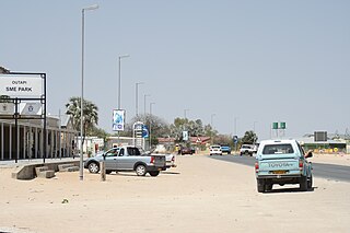
Outapi wa Nakafingo na Temba, also Outapi or Uutapi and Ombalantu, is a town in northern Namibia near the border with Angola, situated 90 km (56 mi) northwest of Oshakati. It is the capital of the Omusati region and the district capital of the Outapi electoral constituency. The language spoken there is Oshiwambo.

<span class="mw-page-title-main">Arandis, Namibia</span> Town in the Erongo Region of Namibia

Arandis is a mining town in the Erongo Region of western central Namibia. Originally a camp for workers of the nearby Rössing uranium mine, Arandis was declared a town in 1994.

<span class="mw-page-title-main">Aroab</span> Village in the ǁKaras Region of Namibia

Aroab is a village with a population of approximately 5,000 in the ǁKaras Region of southern Namibia. It is situated about 170 kilometres (110 mi) south-east of Keetmanshoop on the edge of the Kalahari desert; the average annual rainfall is about 150–200 mm. Aroab is the district centre of the Keetmanshoop Rural electoral constituency.

Okakarara is a town in Otjozondjupa Region, Namibia, located 50 kilometres (31 mi) southeast of Waterberg National Park. It has an estimated population of 7,000 and is currently growing by 1,500 inhabitants annually.

<span class="mw-page-title-main">Otavi Constituency</span> Electoral constituency in the Otjozondjupa region of Namibia

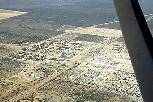
Otavi Constituency is an electoral constituency in the Otjozondjupa Region of Namibia. It had 11,620 inhabitants in 2004 and 9,608 registered voters in 2020. The constituency consists of the town of Otavi and the surrounding rural area.

<span class="mw-page-title-main">Otjinene</span> Village in Omaheke Region, Namibia

Otjinene is a village in the Omaheke Region of Namibia. It is the district capital of the Otjinene Constituency. Otjinene is connected via a 157 kilometres (98 mi) tarred road to the regional capital Gobabis, and via a 227 kilometres (141 mi) road which was tarred in 2017, to Grootfontein.

References

  1. "Table 4.2.2 Urban population by Census years (2001 and 2011)" (PDF). Namibia 2011 - Population and Housing Census Main Report. Namibia Statistics Agency. p. 39. Retrieved 24 August 2016.
  2. "2023 Population & Housing Census Preliminary Report" (PDF). Statistics Namibia.
  3. FAO/WFP CROP, LIVESTOCK AND FOOD SECURITY ASSESSMENT MISSION TO NAMIBIA
  4. Mapcarta
  5. ǃHoaës, Irene (19 November 2010). "Otavi making a U-turn". New Era . Archived from the original on 19 February 2013.
  6. "Otavi steel manufacturing plant to boost construction industry in Namibia". Construction Review Online. 2018-12-02. Retrieved 2020-11-30.
  7. "Know Your Local Authority". Election Watch. No. 3. Institute for Public Policy Research. 2015. p. 4.
  8. "Local elections results". Electoral Commission of Namibia. 28 November 2015. p. 7. Archived from the original on 10 December 2015.
  9. "Publication of results and particulars in respect of general elections for local authority councils: Electoral Act, 2014" (pdf). Government Gazette of the Republic of Namibia . No. 7497. Government of Namibia. 1 April 2021. p. 20.
  10. "Deutscher Bundestag 4. Wahlperiode Drucksache IV/3672" (Archive). Bundestag (West Germany). 23 June 1965. Retrieved on 12 March 2016. p. 32/51.

19°39′S17°20′E / 19.650°S 17.333°E / -19.650; 17.333