
Since 10 December 2020, The Central African Republic is administratively divided into 20 prefectures and the capital city of Bangui, which is an autonomous commune.

Haute-Kotto is one of the 20 prefectures of the Central African Republic. Its capital is Bria. It is the largest prefecture in the Central African Republic.

Haut-Mbomou is one of the 20 prefectures of the Central African Republic. Its capital is Obo. The African Pole of Inaccessibility is located here.

Lobaye is one of the 20 prefectures of the Central African Republic. Its capital is Mbaïki. Emperor Duy Tân of Vietnam died here on December 26, 1945 in a plane crash. David Dacko, the first and third president of the Central African Republic from 1960–1965 and 1979–1981, was from Lobaye.

Mambéré-Kadéï is one of the 20 prefectures of the Central African Republic. The prefecture covers 30,203 km2 and had a population of 197,535 as of the 2003 census, giving a population density of 6.5 inhabitants/km2. Its capital is Berbérati. It is named for the Mambéré River and Kadéï River.

Mbomou is one of the twenty prefectures of the Central African Republic. It covers an area of 61,150 square kilometres (23,610 sq mi) and has a population of 164,009, giving a population density of only 2.7 inhabitants per square kilometre. The capital is Bangassou. Nearby are the Kembe Falls on the River Kotto. The prefecture is governed by Pierrette Benguere.

Ombella-M'Poko is one of the 20 prefectures of the Central African Republic. Its capital is Boali since 10 December 2020. One important tourist attraction is the Falls of Boali; however, due to the Boali dam, the falls only carry water on the weekends.
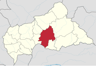
Ouaka is one of the 20 prefectures of the Central African Republic. It borders the Democratic Republic of the Congo, covers an area of 49,900 km2, and has a population of 276,710, giving a population density of 5.5 inhabitants/km2. The capital is Bambari. It is named for the Ouaka River.

Ouham-Pendé is one of the 20 prefectures of the Central African Republic. Its capital is Bozoum. The region contains several ghost towns such as Goroumo, Beogombo Deux and Paoua due to government forces ransacking them and armed bandits killing all the male inhabitants over the years from 2005 to 2008.

Kaga-Bandoro is a market town and capital of the Nana-Grébizi prefecture of the Central African Republic. It represents the seat of the Roman Catholic Diocese of Kaga–Bandoro. The town has been renamed twice.

Bouar is a market town in the western Central African Republic, lying on the main road from Bangui (437 km) to the frontier with Cameroon (210 km). The city is the capital of Nana-Mambéré prefecture, has a population of 40,353, while the whole sous-préfecture has a population of 96,595. Bouar lies on a plateau almost 1000m above sea level and is known as the site of Camp Leclerc, a French military base.
Batangafo is a town located in the Central African Republic prefecture of Ouham-Fafa at the confluence of Ouham River and its affluent Fafa.

Bossangoa is the capital of Ouham, one of the 14 prefectures of the Central African Republic. The town has a population of 36,478. It is located 303 km (189 mi) north of the country's capital, Bangui. The Ouham River passes through Bossangoa and on through a number of waterfalls east of the city before turning north to join the Chari River in Chad.

Bozoum is the capital of Ouham-Pendé, one of the 14 prefectures of the Central African Republic.
Bouca is a town located in the Central African Republic prefecture of Ouham. It is not far east of Bossangoa at the Fafa river.
The Central African Republic is divided into 20 prefectures and one autonomous commune. The prefectures (préfectures) are further divided into 84 sub-prefectures (sous-préfectures).

Health in the Central African Republic has been degraded by years of internal conflict and economic turmoil since independence from France in 1960. One sixth of the country's population is in need of acute medical care. Endemic diseases put a high demand on the health infrastructure, which requires outside assistance to sustain itself.
Nanga-Boguila is a sub-prefecture of Ouham in the Central African Republic.
Koui is a sub-prefecture of Ouham-Pendé in the Central African Republic.

Ouham-Fafa is a prefecture in Central African Republic. With an area of 32,530 km2, the prefecture had a population of 225,479 in 2022. Batangafo is the capital of Ouham-Fafa.

