Outline of Transnistria

Last updated
The location of Transnistria Europe location Pridnestrovie.png
The location of Transnistria
An enlargeable map of Transnistria PMRroadmap.jpg
An enlargeable map of Transnistria

The following outline is provided as an overview of and topical guide to Transnistria:

Contents

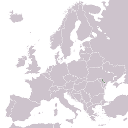
Transnistria is a breakaway state located mostly on a strip of land between the River Dniester and the eastern Moldovan border with Ukraine. Since its declaration of independence in 1990, and especially after the War of Transnistria in 1992, it has been governed as the Pridnestrovian Moldavian Republic (PMR, also known as Pridnestrovie), a state with limited recognition that claims territory to the east of the River Dniester, and also to the city of Bender (Tighina) and its surrounding localities on the west bank in the historical region of Bessarabia. The names "Transnistria" and "Pridnestrovie" both refer to the Dniester River. Unrecognised by any United Nations member state, Transnistria is designated by the Republic of Moldova as the Transnistria autonomous territorial unit with special legal status (Unitatea teritorială autonomă cu statut juridic special Transnistria), or Stînga Nistrului ("Left Bank of the Dniester").

General reference

Geography of Transnistria

Geography of Transnistria

Environment of Transnistria

Regions of Transnistria

Regions of Transnistria

Ecoregions of Transnistria

List of ecoregions in Transnistria

Administrative divisions of Transnistria

Administrative divisions of Transnistria

Raions of Transnistria

Raions of Transnistria

Municipalities of Transnistria

Municipalities of Transnistria

Demography of Transnistria

Demographics of Transnistria

Government and politics of Transnistria

Politics of Transnistria

Branches of the government of Transnistria

Government of Transnistria

Executive branch of the government of Transnistria

Legislative branch of the government of Transnistria

Judicial branch of the government of Transnistria

Court system of Transnistria

Foreign relations of Transnistria

Foreign relations of Transnistria

International organization membership

Law and order in Transnistria

Law of Transnistria

Military of Transnistria

Military of Transnistria

Local government in Transnistria

Local government in Transnistria

History of Transnistria

History of Transnistria

Culture of Transnistria

Art in Transnistria

Economy and infrastructure of Transnistria

Economy of Transnistria

Education in Transnistria

Education in Transnistria

See also

Related Research Articles

<span class="mw-page-title-main">Transnistria</span> Unrecognised state in Eastern Europe

Transnistria, officially the Pridnestrovian Moldavian Republic (PMR), is an unrecognised state internationally considered to be part of Moldova. Transnistria controls most of the narrow strip of land between the Dniester river and the Moldovan–Ukrainian border, as well as some land on the other side of the river's bank. Its capital and largest city is Tiraspol. Transnistria has been recognised only by three other unrecognised or partially recognised breakaway states: Abkhazia, Artsakh and South Ossetia. Transnistria is officially designated by the Republic of Moldova as the Administrative-Territorial Units of the Left Bank of the Dniester or as Stînga Nistrului. In March 2022, the Parliamentary Assembly of the Council of Europe adopted a resolution that defines the territory as under military occupation by Russia.

<span class="mw-page-title-main">Administrative divisions of Moldova</span>

According to the Moldovan law on territorial administrative organisation, Moldova is divided administratively into the following administrative territorial units: districts, cities/towns and villages. The administrative territorial organization of Moldova is made on 2 levels:

  1. villages (communes), sectors and cities/towns (municipii) constitute the first level,
<span class="mw-page-title-main">Grigoriopol</span> Town in Transnistria, Moldova

Grigoriopol is a town in the Administrative-Territorial Units of the Left Bank of the Dniester, Moldova. It is the seat of the Grigoriopol District of Transnistria. The city is located on the left (eastern) bank of the river Dniester at 47°09′N29°18′E, in central Transnistria. Grigoriopol is composed of the city itself, and a small village Crasnoe (Красное). The town itself had a population of 11,473 in 2004.

<span class="mw-page-title-main">Transnistria War</span> 1990–1992 conflict between Moldova and Russian-backed self-proclaimed Transnistria

The Transnistria War was an armed conflict that broke out on 2 November 1990 in Dubăsari between pro-Transnistria forces, including the Transnistrian Republican Guard, militia and neo-Cossack units, which were supported by elements of the Russian 14th Army, and pro-Moldovan forces, including Moldovan troops and police.

<span class="mw-page-title-main">Transnistria conflict</span> Conflict between Moldova and its breakaway region of Transnistria since 1990

The Transnistria conflict is an ongoing frozen conflict between Moldova and the unrecognized state of Transnistria. Its most active phase was the Transnistria War. There have been several attempts to resolve the conflict, although none have been successful. The conflict may be considered as having started on 2 September 1990, when Transnistria made a formal sovereignty declaration from Moldova.

<span class="mw-page-title-main">History of Transnistria</span> Aspect of history

This is the history of Transnistria, officially the Pridnestrovian Moldavian Republic (PMR), an unrecognised breakaway state that is internationally recognised as part of Moldova. Transnistria controls most of the narrow strip of land between the Dniester river and the Moldovan–Ukrainian border, as well as some land on the other side of the river's bank.

This is a survey of the postage stamps and postal history of Transnistria, an unrecognized breakaway territory of Moldova and the de facto independent Pridnestrovian Moldavian Republic.

<span class="mw-page-title-main">Romanian-language schools in Transnistria</span> Schools teaching in the Romanian language in Transnistria

The Romanian-language schools in Transnistria are subject to limitations by the government of Transnistria, an unrecognized breakaway region of Moldova since 1992.

Although most commonly known in English as Transnistria, the official name of the region is Pridnestrovie. Here is a detailed explanation of the names used for Transnistria, both official and unofficial, as they appear in the local languages and in English.

The mass media of Transnistria, the breakaway territory within the borders of Moldova, features both state-owned or supported outlets and opposition media. Publications are in Russian, with a single newspaper in each of the other two official languages, Moldovan (Romanian), and Ukrainian.

Doroțcaia is a village in the Dubăsari District, Republic of Moldova, situated on the eastern bank of the River Dniester.

<span class="mw-page-title-main">Rașcov</span> Commune in Transnistria, Moldova

Rașcov is one of the oldest communes of Transnistria. It is located in the northern part, between Rîbnița and Camenca. It is composed of two villages, Iantarnoe and Rașcov.

<span class="mw-page-title-main">Pridnestrovian Moldavian Soviet Socialist Republic</span> Short-lived non-recognized Soviet republic

The Pridnestrovian Moldavian Soviet Socialist Republic (PMSSR), also commonly known as Soviet Transnistria or simply as Transnistria, was created on the eastern periphery of the Moldavian Soviet Socialist Republic (MSSR) in 1990 by pro-Soviet separatists who hoped to remain within the Soviet Union when it became clear that the MSSR would achieve independence from the USSR and possibly unite with Romania. The PMSSR was never recognised as a Soviet republic by the authorities in either Moscow or Chișinău. In 1991, the Pridnestrovian Moldavian Republic succeeded the Pridnestrovian Moldavian Soviet Socialist Republic.

<span class="mw-page-title-main">Demographic history of Transnistria</span> Aspect of history

A demographic history of Transnistria shows that Transnistria has been home to numerous ethnic groups, in varying proportions, over time.

<span class="mw-page-title-main">Timeline of the Transnistria War</span> A chronological list of incidents related to the Transnistria War

This timeline of events is a chronological list of incidents and other notable occurrences related to the War of Transnistria, including events leading up to the war.

<span class="mw-page-title-main">Armed Forces of Transnistria</span> Military forces of the state of Transnistria

The Armed Forces of the Pridnestrovian Moldavian Republic are the military forces of the unrecognized state of Transnistria. The Armed Forces fall under the leadership of the Ministry of Defence. The Armed Forces were created on 6 September 1991 to maintain the sovereignty and independence of the Pridnestrovian Moldavian Republic, in accordance with Article 11 of the Republic's Constitution.

<span class="mw-page-title-main">Shevchenko Transnistria State University</span>

Two universities claim the succession of the Taras Shevchenko State University of Tiraspol: Transnistrian State University located in Tiraspol, Transnistria, and Tiraspol State University located in Chișinău, Moldova.

<span class="mw-page-title-main">Administrative divisions of Transnistria</span>

The Pridnestrovian Moldavian Republic is subdivided into five raions:

<span class="mw-page-title-main">Women in Transnistria</span>

Women in Transnistria are women who live in or are from Transnistria.

The M4 highway is a road in Transnistria, Moldova. It runs from the south to the north, being 178 km (111 mi) long, and links the Transnistrian capital of Tiraspol with Rîbnița via Dubăsari, reaching the border with Ukraine at Hristovaia, where it merges with the Ukrainian local road T0225. Running along the left bank of the Dniester for most of its length, it is the only road with magistral road status that does not start nor pass through the Moldovan capital of Chișinău.

References

  1. Jos Boonstra, Senior Researcher, Democratisation Programme, FRIDE. Moldova, Transnistria and European Democracy Policies Archived 2018-08-08 at the Wayback Machine , 2007
  2. Gerald Hinteregger, Hans-Georg Heinrich (editors), Russia — Continuity and Change, Hinteregger, Gerald; Heinrich Hans-Georg (2004). Russia — Continuity and Change. (editors). Springer. pp.  174. ISBN   3-211-22391-6.
  3. Rosenstiel, Francis; Edith Lejard; Jean Boutsavath; Jacques Martz (2002). Annuaire Europeen 2000/European Yearbook 2000. Martinus Nijhoff Publishers. ISBN   90-411-1844-6.
  4. Barry Bartmann, Tozun. Bahcheli (2004). De Facto States: The Quest for Sovereignty. Routledge. ISBN   0-7146-5476-0.
  5. "Moldova". The World Factbook . United States Central Intelligence Agency. July 2, 2009. Retrieved July 23, 2009.

Gnome-globe.svg Wikimedia Atlas of Transnistria

Local links