
The United States Virgin Islands, officially the Virgin Islands of the United States, are a group of Caribbean islands and an unincorporated and organized territory of the United States. The islands are geographically part of the Virgin Islands archipelago and are located in the Leeward Islands of the Lesser Antilles.

Politics of the United States Virgin Islands takes place in a framework of a presidential representative democratic dependency, whereby the Governor is the head of the territory's government, and of a multi-party system. United States Virgin Islands are an unincorporated and organized territory of the United States, administered by the Office of Insular Affairs of the United States Department of the Interior. Executive power is exercised by the local government of the Virgin Islands. The judiciary is independent of the executive and the legislature.

The Virgin Islands are an archipelago in the Caribbean Sea. They are geologically and biogeographically the easternmost part of the Greater Antilles, the northern islands belonging to the Puerto Rico Trench and St. Croix being a displaced part of the same geologic structure. Politically, the British Virgin Islands have been governed as the western island group of the Leeward Islands, which are the northern part of the Lesser Antilles, and form the border between the Caribbean Sea and the Atlantic Ocean. The archipelago is separated from the true Lesser Antilles by the Anegada Passage and from the main island of Puerto Rico by the Virgin Passage.
The Danish West Indies or Danish Virgin Islands or Danish Antilles were a Danish colony in the Caribbean, consisting of the islands of Saint Thomas with 32 square miles (83 km2); Saint John with 19 square miles (49 km2); and Saint Croix with 84 square miles (220 km2). The islands have belonged to the United States as the Virgin Islands since they were purchased in 1917. Water Island was part of the Danish West Indies until 1905, when the Danish state sold it to the East Asiatic Company, a private shipping company.

Charlotte Amalie, located on St. Thomas, is the capital and the largest city of the United States Virgin Islands. It was founded in 1666 as Taphus. In 1691, the town was renamed to Charlotte Amalie after the Danish queen Charlotte Amalie of Hesse-Kassel (1650–1714). It has a deep-water harbor that was once a haven for pirates and is now one of the busiest ports of call for cruise ships in the Caribbean, with about 1.5 million-plus cruise ship passengers landing there annually. Protected by Hassel Island, the harbor has docking and fueling facilities, machine shops, and shipyards and was a U.S. submarine base until 1966. The Town has been inhabited for centuries. When Christopher Columbus arrived in 1493, the area was inhabited by Caribs, Arawaks, Ciboney and Taíno native peoples. It is on the southern shore at the head of Saint Thomas Harbor. In 2010 the City had a population of 18,481, which makes it the largest city in the Virgin Islands Archipelago. Hundreds of ferries and yachts pass by the Town each week.

The Lesser Antilles are a group of islands in the Caribbean Sea. They are distinguished from the large islands of the Greater Antilles to the west. They form an arc which begins east of Puerto Rico and swings south thru the Leeward and Windward Islands almost to South America and then turns west along the Venezuelan coast as far as Aruba. Barbados is isolated about 100 miles east of the Windwards.
Saint Croix is an island in the Caribbean Sea, and a county and constituent district of the United States Virgin Islands (USVI), an unincorporated territory of the United States.

The Antilles is an archipelago bordered by the Caribbean Sea to the south and west, the Gulf of Mexico to the northwest, and the Atlantic Ocean to the north and east.

Saint Thomas is one of the Virgin Islands in the Caribbean Sea, and a constituent district of the United States Virgin Islands (USVI), an unincorporated territory of the United States. Along with surrounding minor islands, it is one of three county-equivalents in the USVI. Together with Saint John, it forms one of the districts of the USVI. The territorial capital and port of Charlotte Amalie is located on the island. As of the 2020 census, the population of Saint Thomas was 42,261, about 48.5% of the total population of the United States Virgin Islands. The island has a land area of 32 square miles (83 km2).
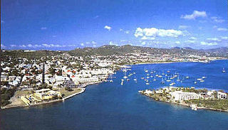
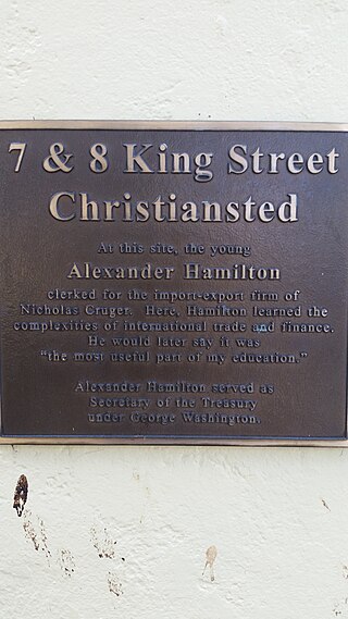
Christiansted is the largest town on Saint Croix, one of the main islands composing the United States Virgin Islands, a territory of the United States of America. The town is named after King Christian VI of Denmark.

The United States Virgin Islands, often abbreviated USVI, are a group of islands and cays located in the Lesser Antilles of the Eastern Caribbean, consisting of three main islands and fifty smaller islets and cays. Like many of their Caribbean neighbors, the history of the islands is characterized by native Amerindian settlement, European colonization, and the Atlantic slave trade.

The West Indies is a subregion of North America, surrounded by the North Atlantic Ocean and the Caribbean Sea, which comprises 13 independent island countries and 19 dependencies in three archipelagos: the Greater Antilles, the Lesser Antilles, and the Lucayan Archipelago.

The following outline is provided as an overview of and topical guide to the Collectivity of Saint Martin:

The following is an alphabetical list of articles related to the territory of the United States Virgin Islands.

The Caribbean is a subregion of the Americas that includes the Caribbean Sea and its islands, some of which are surrounded by the Caribbean Sea and some of which border both the Caribbean Sea and the North Atlantic Ocean; the nearby coastal areas on the mainland are often also included in the region. The region is southeast of the Gulf of Mexico and the North American mainland, east of Central America, and north of South America.

Sugar production in the United States Virgin Islands was an important part of the economy of the United States Virgin Islands for over two hundred years. Long before the islands became part of the United States in 1917, the islands, in particular the island of Saint Croix, was exploited by the Danish from the early 18th century and by 1800 over 30,000 acres were under cultivation, earning Saint Croix a reputation as the "Garden of the West Indies". Since the closing of the last sugar factory on Saint Croix in 1966, the industry has become only a memory.

Arnold Ray Highfield was an American professor, historian, writer, and poet, best known for his historical works on the Danish West Indies and the United States Virgin Islands.

The fauna of the United States Virgin Islands consists of 144 species of birds, 22 species of mammals, 302 species of fish and 7 species of amphibians. The wildlife of the U.S.V.I. includes numerous endemic species of tropical birds, fish, and land reptiles as well as sea mammals. The only endemic land mammals are six species of native bats: the greater bulldog bat, Antillean fruit-eating bat, red fruit bat, Brazilian free-tailed bat, velvety free-tailed bat and the Jamaican fruit bat. Some of the nonnative land mammals roaming the islands are the white-tailed deer, small Asian mongoose, goats, feral donkeys, rats, mice, sheep, hogs, dogs and cats.
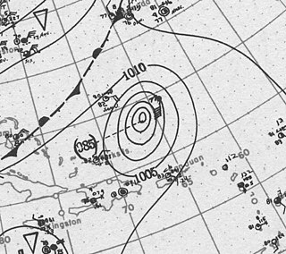
The 1916 Virgin Islands hurricane was a strong tropical cyclone that inflicted extensive damage across the Virgin Islands in October 1916. It was the region's most destructive storm since at least the 1867 San Narciso hurricane; Consul General Christopher Payne and archaeologist Theodoor de Booy considered the 1916 storm as the archipelago's most damaging. Its peak intensity was equivalent to a Category 3 on the modern Saffir–Simpson scale. The storm began as a tropical depression southeast of Barbados on October 6, though little is known about the storm's origins or its developing stages; by the time its center was first located, the cyclone was already a hurricane and causing damage in the Virgin Islands. After forming, the storm moved northwest into the eastern Caribbean Sea and strengthened quickly. Rough seas were produced in the Windward Islands at Dominica and Saint Kitts as the storm passed nearby between October 7–8, damaging coastal villages.


