
Overlapping spreading centers are a feature of spreading centers at mid-ocean ridges.
Overlapping spreading centers are a feature of spreading centers at mid-ocean ridges.
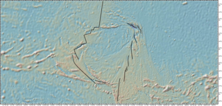
In the normal case adjacent spreading centers not on the same trend, end at a transform fault that appears to offset each center. At an overlapping spreading center the adjacent centers overlap and are not connected by a transform fault. [1] [2] [3] In plan view, overlapping spreading centers look like two people about to shake hands but over-reaching by a distance that is three times the distance between the hands. [2] This 3:1 overlap to offset ratio (observed at a wide range of scales, from hundreds of meters to tens of km) holds the key to their mechanism of formation. In fracture mechanics, when two cracks propagate toward each other, they tend to deflect away from each other, propagate past each other, and then stall out when the ratio is 3:1 because at this point the crack propagation force drops to zero. [4]
What results are two spreading centers overlapping, apparently pushing against each other, which would violate one of the rules of plate tectonics: plates are rigid. This paradox is solved by the fact that the overlapping spreading centers are non-steady-state and propagate along the ridge; as one segment lengthens, the neighboring segment shortens. Which segment lengthens, is arbitrary; evidence shows that at times the spreading center tips have alternated migrating directions. [2] The discovery of overlapping spreading centers revealed the time-varying behavior of mid-ocean ridge segments, with implications for magmatism, volcanism and patterns of hydrothermal activity. [5]
Overlapping spreading centers are found mostly on mid-ocean ridge spreading centers in the Pacific Ocean basin where the rates of separation between the plates are higher than in other ocean basins. [6] [7] They occur on all fast-spreading rate centers (>90 mm/yr) including the East Pacific Rise, and on most intermediate-rate spreading centers (50–90 mm/yr), such as the Galapagos Spreading Center, the Juan de Fuca Ridge and the Pacific-Antarctic Ridge. [8] [9]
Seafloor spreading or Seafloor spread is a process that occurs at mid-ocean ridges, where new oceanic crust is formed through volcanic activity and then gradually moves away from the ridge.
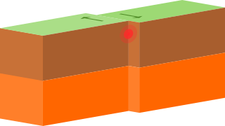
A transform fault or transform boundary, sometimes called a strike-slip boundary, is a fault along a plate boundary where the motion is predominantly horizontal. It ends abruptly where it connects to another plate boundary, either another transform, a spreading ridge, or a subduction zone. A transform fault is a special case of a strike-slip fault that also forms a plate boundary.
The East Pacific Rise is a mid-oceanic ridge, a divergent tectonic plate boundary located along the floor of the Pacific Ocean. It separates the Pacific Plate to the west from the North American Plate, the Rivera Plate, the Cocos Plate, the Nazca Plate, and the Antarctic Plate. It runs south from the Gulf of California in the Salton Sea basin in Southern California to a point near 55° S, 130° W, where it joins the Pacific-Antarctic Ridge trending west-southwest towards Antarctica, near New Zealand. Much of the rise lies about 3200 km (2000 mi) off the South American coast and rises about 1,800–2,700 m (6,000–9,000 ft) above the surrounding seafloor.

A fracture zone is a linear oceanic feature—often hundreds, even thousands of kilometers long—resulting from the action of offset mid-ocean ridge axis segments. They are a consequence of plate tectonics. Lithospheric plates on either side of an active transform fault move in opposite directions; here, strike-slip activity occurs. Fracture zones extend past the transform faults, away from the ridge axis; seismically inactive, they display evidence of past transform fault activity, primarily in the different ages of the crust on opposite sides of the zone.

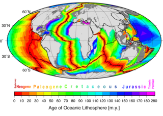
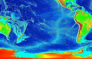
A mid-ocean ridge (MOR) is a seafloor mountain system formed by plate tectonics. It typically has a depth of about 2,600 meters (8,500 ft) and rises about 2,000 meters (6,600 ft) above the deepest portion of an ocean basin. This feature is where seafloor spreading takes place along a divergent plate boundary. The rate of seafloor spreading determines the morphology of the crest of the mid-ocean ridge and its width in an ocean basin. The production of new seafloor and oceanic lithosphere results from mantle upwelling in response to plate separation. The melt rises as magma at the linear weakness between the separating plates, and emerges as lava, creating new oceanic crust and lithosphere upon cooling. The first discovered mid-ocean ridge was the Mid-Atlantic Ridge, which is a spreading center that bisects the North and South Atlantic basins; hence the origin of the name 'mid-ocean ridge'. Most oceanic spreading centers are not in the middle of their hosting ocean basis but regardless, are traditionally called mid-ocean ridges. Mid-ocean ridges around the globe are linked by plate tectonic boundaries and the trace of the ridges across the ocean floor appears similar to the seam of a baseball. The mid-ocean ridge system thus is the longest mountain range on Earth, reaching about 65,000 km (40,000 mi).

The Juan de Fuca Ridge is a mid-ocean spreading center and divergent plate boundary located off the coast of the Pacific Northwest region of North America. The ridge separates the Pacific Plate to the west and the Juan de Fuca Plate to the east. It runs generally northward, with a length of approximately 500 kilometres (310 mi). The ridge is a section of what remains from the larger Pacific-Farallon Ridge which used to be the primary spreading center of this region, driving the Farallon Plate underneath the North American Plate through the process of plate tectonics. Today, the Juan de Fuca Ridge pushes the Juan de Fuca Plate underneath the North American plate, forming the Cascadia Subduction Zone.
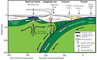
Back-arc basins are geologic basins, submarine features associated with island arcs and subduction zones. They are found at some convergent plate boundaries, presently concentrated in the western Pacific Ocean. Most of them result from tensional forces caused by oceanic trench rollback and the collapse of the edge of the continent. The arc crust is under extension or rifting as a result of the sinking of the subducting slab. Back-arc basins were initially a surprising result for plate tectonics theorists, who expected convergent boundaries to be zones of compression, rather than major extension. However, they are now recognized as consistent with this model in explaining how the interior of Earth loses heat.
Easter Plate is a tectonic microplate located to the west of Easter Island off the west coast of South America in the middle of the Pacific Ocean, bordering the Nazca Plate to the east and the Pacific Plate to the west. It was discovered from looking at earthquake distributions that were offset from the previously perceived Nazca-Pacific Divergent boundary. This young plate is 5.25 million years old and is considered a microplate because it is small with an area of approximately 160,000 square kilometres (62,000 sq mi). Seafloor spreading along the Easter microplate's borders have some of the highest global rates, ranging from 50 to 140 millimetres /yr.

The Izu–Bonin–Mariana (IBM) arc system is a tectonic plate convergent boundary in Micronesia. The IBM arc system extends over 2800 km south from Tokyo, Japan, to beyond Guam, and includes the Izu Islands, the Bonin Islands, and the Mariana Islands; much more of the IBM arc system is submerged below sealevel. The IBM arc system lies along the eastern margin of the Philippine Sea Plate in the Western Pacific Ocean. It is the site of the deepest gash in Earth's solid surface, the Challenger Deep in the Mariana Trench.

The Rodrigues Triple Junction (RTJ), also known as the Central Indian [Ocean] Triple Junction (CITJ) is a geologic triple junction in the southern Indian Ocean where three tectonic plates meet: the African Plate, the Indo-Australian Plate, and the Antarctic Plate. The triple junction is named for the island of Rodrigues which lies 1,000 km (620 mi) north-west of it.

The Southwest Indian Ridge (SWIR) is a mid-ocean ridge located along the floors of the south-west Indian Ocean and south-east Atlantic Ocean. A divergent tectonic plate boundary separating the Somali Plate to the north from the Antarctic Plate to the south, the SWIR is characterised by ultra-slow spreading rates combined with a fast lengthening of its axis between the two flanking triple junctions, Rodrigues in the Indian Ocean and Bouvet in the Atlantic Ocean.

The Southeast Indian Ridge (SEIR) is a mid-ocean ridge in the southern Indian Ocean. A divergent tectonic plate boundary stretching almost 6,000 km (3,700 mi) between the Rodrigues Triple Junction in the Indian Ocean and the Macquarie Triple Junction in the Pacific Ocean, the SEIR forms the plate boundary between the Australian and Antarctic plates since the Oligocene (anomaly 13).

The Macquarie Triple Junction is a geologically active tectonic boundary located at 61°30′S161°0′E at which the Indo-Australian Plate, Pacific Plate, and Antarctic Plate collide and interact. The term Triple Junction is given to particular tectonic boundaries at which three separate tectonic plates meet at a specific, singular location. The Macquarie Triple Junction is located on the seafloor of the southern region of the Pacific Ocean, just south of New Zealand. This tectonic boundary was named in respect to the nearby Macquarie Island, which is located southeast of New Zealand.

The Lau Basin is a back-arc basin at the Australian-Pacific plate boundary. It is formed by the Pacific plate subducting under the Australian plate. The Tonga-Kermadec Ridge, a frontal arc, and the Lau-Colville Ridge, a remnant arc, sit to the eastern and western sides of the basin, respectively.

The North Fiji Basin (NFB) is an oceanic basin west of Fiji in the south-west Pacific Ocean. It is an actively spreading back-arc basin delimited by the Fiji islands to the east, the inactive Vitiaz Trench to the north, the Vanuatu/New Hebrides island arc to the west, and the Hunter fracture zone to the south. Roughly triangular in shape with its apex located at the northern end of the New Hebrides Arc, the basin is actively spreading southward and is characterised by three spreading centres and an oceanic crust younger than 12 Ma. The opening of the NFB began when a slab roll-back was initiated beneath the New Hebrides and the island arc started its clockwise rotation. The opening of the basin was the result of the collision between the Ontong Java Plateau and the Australian Plate along the now inactive Solomon–Vitiaz subduction system north of the NFB. The NFB is the largest and most developed back-arc basin of the south-west Pacific. It is opening in a complex geological setting between two oppositely verging subduction systems, the New Hebrides/Vanuatu and Tonga trenches and hence its ocean floor has the World's largest amount of spreading centres per area.

Kenneth Craig Macdonald is an American oceanographer and marine geophysicist born in San Francisco, California in 1947. As of 2018 he is Professor Emeritus at the Department of Earth Science and the Marine Sciences Institute at the University of California, Santa Barbara (UCSB). His work focuses on the tectonics and geophysics of the global mid-oceanic ridge including its spreading centers and transform faults, two of the three types of plate boundaries central to the theory of plate tectonics. His work has taken him to the north and south Atlantic oceans, the north and south Pacific oceans, the Indian Ocean, the Red Sea and the Sea of Cortez, as well as to the deep seafloor on over 50 dives in the research submersible ALVIN. Macdonald has participated in over 40 deep sea expeditions, and was Chief- or Co-Chief Scientist on 31 expeditions.
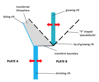
A propagating rift is a seafloor feature associated with spreading centers at mid-ocean ridges and back-arc basins. They are more commonly observed on faster rate spreading centers. These features are formed by the lengthening of one spreading segment at the expense of an offset neighboring spreading segment. Hence, these are remnant features produced by migration of the tip of a spreading center. In other words, as the tip of a spreading center migrates or grows, the plate itself grows at the expense of the shrinking plate, transferring lithosphere from the shrinking plate to the growing plate.
Marine geophysics is the scientific discipline that employs methods of geophysics to study the world's ocean basins and continental margins, particularly the solid earth beneath the ocean. It shares objectives with marine geology, which uses sedimentological, paleontological, and geochemical methods. Marine geophysical data analyses led to the theories of seafloor spreading and plate tectonics.

The Chile Ridge, also known as the Chile Rise, is a submarine oceanic ridge formed by the divergent plate boundary between the Nazca Plate and the Antarctic Plate. It extends from the triple junction of the Nazca, Pacific, and Antarctic plates to the Southern coast of Chile. The Chile Ridge is easy to recognize on the map, as the ridge is divided into several segmented fault zones which are perpendicular to the ridge segments, showing an orthogonal shape toward the spreading direction. The total length of the ridge segments is about 550–600 km.