Studley is a large village and civil parish in the Stratford-on-Avon district of Warwickshire, England. Situated on the western edge of Warwickshire near the border with Worcestershire, it is 3.5 miles (6 km) southeast of Redditch and 13 miles (21 km) northwest of Stratford-upon-Avon. The Roman road of Ryknild Street, now the A435, passes through the village on its eastern edge, parallel to the River Arrow. The name derives from the Old English leah, being a meadow or pasture, where horses, stod, are kept.

The Collegiate Church of the Holy and Undivided Trinity, Stratford-upon-Avon, is a Grade I listed parish church of the Church of England in Stratford-upon-Avon, Warwickshire, England. It is often known simply as Holy Trinity Church or as Shakespeare's Church, due to its fame as the place of baptism, marriage and burial of William Shakespeare. More than 200,000 tourists visit the church each year.

Aston Cantlow is a village in Warwickshire, England, on the River Alne 5 miles (8.0 km) north-west of Stratford and 2 miles (3.2 km) north-west of Wilmcote, close to Little Alne, Shelfield, and Newnham. It was the home of Mary Arden, Shakespeare's mother. At the 2001 census, it had a population of 1,674, being measured again as 437 at the 2011 Census.

Bearley is a village and civil parish in the Stratford-on-Avon district of Warwickshire, England. The village is about five miles (8 km) north of Stratford-upon-Avon, bounded on the north by Wootton Wawen, on the east by Snitterfield, and on the south and west by Aston Cantlow. The western boundary is formed by a stream running out of Edstone Lake; it would seem that the land, now part of Edstone in Wootton Wawen, between the stream where it flows west from the lake and the road running east from Bearley Cross, was originally included in Bearley.

Mickleton, with a population of 1,677, an increase of 125 since the census of 1991, is the northernmost village in Gloucestershire, England.

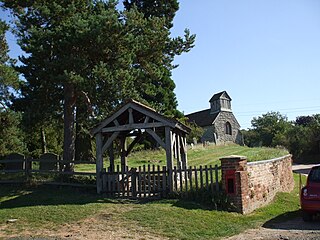
Kinwarton is a village in the valley of the River Alne, Warwickshire, to the north east of the market town of Alcester. The population of the civil parish at the 2011 census was 1,082. The ground is mostly low-lying, with a maximum altitude of 206 ft. and some of the fields near the river are liable to floods. The road from Alcester to Henley-in-Arden runs through the middle of the parish. A branch road leads off to the church and rectory about a quarter of a mile to the south and thence continues as a field-path down to a ford across the River Alne below Hoo Mill. From the north side of the main road a by-road branches off to Coughton.

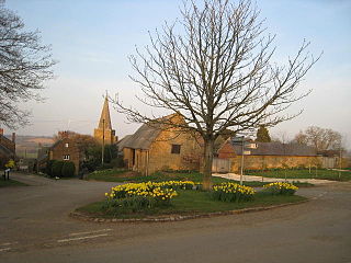
Temple Grafton is a village and civil parish in the Stratford district of Warwickshire, England, situated about 4 miles (6.4 km) east of Alcester and 14 miles (23 km) west of the county town of Warwick. The place name is misleading, the Knights Templar never having any association with the place but owing to a naming error made in the time of Henry VIII the mistake has been perpetuated. During the reign of Richard I the estate in fact belonged to the Knights Hospitaller. During the reign of Edward III in 1347 the village was recorded as Grafton Superior while neighbouring Ardens Grafton was named Inferior

Snitterfield is a village and civil parish in the Stratford on Avon district of Warwickshire, England, less than 1 mile (1.6 km) to the north of the A46 road, 4.5 miles (7.2 km) from Stratford upon Avon, 6.5 miles (10.5 km) from Warwick and 17 miles (27 km) from Coventry. The population of the civil parish at the 2011 census was 1,226.

Wixford is a hamlet and civil parish in the Stratford-on-Avon District of Warwickshire, England, situated 1.5 miles (2.4 km) south of Alcester. The population at the 2011 census was 155. The name derives from a compound of the Old English personal name Whitlac with the noun for a river crossing "ford". William Shakespeare is said to have joined a party of Stratford folk which set itself to outdrink a drinking club at Bidford-on-Avon, and as a result of his labours in that regard to have fallen asleep under the crab tree of which a descendant is still called Shakespeare's tree. When morning dawned, his friends wished to renew the encounter but he wisely said "No, I have drunk with "Piping Pebworth, Dancing Marston, Haunted Hillboro', Hungry Grafton, Dodging Exhall, Papist Wixford, Beggarly Broom and Drunken Bidford" and so, presumably, I will drink no more. The story is said to date from the 17th century, but of its truth or of any connection of the story or the verse to Shakespeare there is no evidence. The reasons for the village being described as papist remain unclear, but may be a reference to the Catholic Throckmorton family. In 1541, the village passed to Sir George Throckmorton, in whose family it remained until 1919, when the estate was sold and the manorial rights extinguished.

Stratford-sub-Castle in Wiltshire, England was anciently a separate village and civil parish but since 1954 has been a northern suburb of the city of Salisbury. At approximately 170 ft above sea level, it is dominated to the east by the remains of an Iron Age hillfort within the boundaries of which a Norman castle was built. This now-ruined castle led to the village taking the name Stratford-under-Castle, later changing to Stratford sub Castle. Stratford lies south-west of the abandoned medieval settlement of Old Sarum which was also built within the area of the hill fort. It is approximately twenty one miles from Southampton.

Great Wolford is a village and civil parish at the bottom of a hill in the Stratford-on-Avon district of Warwickshire, England. With the neighbouring parish of Little Wolford it is part of 'The Wolfords'.

Whatcote is a village and civil parish in Warwickshire, England, about 4 miles (6.4 km) northeast of Shipston on Stour in the Vale of the Red Horse. The population at the 2011 census was 143.
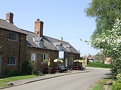
Morton Bagot is a small village in the Stratford-on-Avon district of Warwickshire, England. The population from the 2011 Census is included within Redditch(Worcs). It lies about 1.5 miles (2 km) east of the Birmingham-Alcester road, the modern A435 and Roman Ryknild Street, 6.5 miles (10 km) north of Alcester, 9.5 miles (15 km) from Stratford upon Avon and 12 miles from Warwick, across the valley of a small brook, flowing south-east to join the River Arrow. A road from Oldberrow to Spernall runs north and south through the middle of the parish of Morton Bagot, Oldberrow and Spernall, past the church. The name means the settlement of the moor, the Bagot element coming from the name of the lords of the Manor who added their name when they came into possession during the reign of Henry II.

Exhall is a village and civil parish about 1+1⁄4 miles (2 km) south-south-east of Alcester in the Stratford-on-Avon district of Warwickshire, England. Its parish includes the hamlet of Little Britain and part of Ardens Grafton, the greater part of which is in the neighbouring civil parish of Temple Grafton. The 2011 Census recorded Exhall parish's population as 203.

St John the Baptist's Church is a redundant Anglican church in the village of Avon Dassett, Warwickshire, England. It is recorded in the National Heritage List for England as a designated Grade II* listed building, and is under the care of The Churches Conservation Trust.
Shotteswell is a village and civil parish in the Stratford-on-Avon district of Warwickshire. The population of the civil parish at the 2011 census was 221. The parish is bounded on three sides by Oxfordshire and is about 4 miles (6 km) north-west of Banbury.

St Helen's Church is an Anglican church in the village of Churchtown in Lancashire, England. Historically, it was the parish church of Garstang; today, as Garstang is split into more than one ecclesiastical parish, St Helen's parish is Garstang St Helen (Churchtown). It is in the Diocese of Blackburn. It has been designated a Grade I listed building by English Heritage. St Helen's is known as the "cathedral of The Fylde".

Preston Bagot is a village and civil parish in the Stratford district of Warwickshire, England, about 6 miles (9.7 km) west of the county town of Warwick. According to the 2001 census the population was 147, reducing to 127 at the 2011 Census.

Tidmington is a village and civil parish in the Stratford-on-Avon District of Warwickshire, England. It is 11 miles (18 km) south from the town of Stratford-upon-Avon, and at the extreme southern edge of the county bordering Gloucestershire. Within the parish is the Grade II* listed c.1600 Tidmington House, and the Grade II* early 13th-century church of unknown dedication.

St Laurence's Church is a Church of England parish church in Upwey, Dorset, England. Much of the existing church dates to the late 15th-century, with some earlier fabric and later additions of the 19th and 20th-centuries. It is a Grade II* listed building.