
A disaster is a serious problem that happens over a period of time and causes so much harm to people, things, economies, or the environment that the affected community or society cannot handle it on its own. In theory, natural disasters are those caused by natural hazards, whereas human-made disasters are those caused by human hazards. However, in modern times, the divide between natural, human-made or human-accelerated disasters is more and more difficult to draw. In fact, all disasters can be seen as human-made, due to human failure to introduce appropriate emergency management measures.

A natural disaster is the highly harmful impact on a society or community following a natural hazard event. Examples of natural hazard events include floods, droughts, earthquakes, tropical cyclones, volcanic activity, wildfires. A natural disaster can cause loss of life or damage property, and typically leaves economic damage in its wake. The severity of the damage depends on the population's disaster preparedness and on the existing infrastructure. Scholars have been saying that the term natural disaster is unsuitable and should be abandoned. Instead, the simpler term disaster could be used, while also specifying the category of hazard. A disaster is a result of a natural or human-made hazard impacting a vulnerable community. It is the combination of the hazard along with exposure of a vulnerable society that results in a disaster.

The Hawaiian Islands are an archipelago of eight major volcanic islands, several atolls, and numerous smaller islets in the North Pacific Ocean, extending some 1,500 miles from the island of Hawaiʻi in the south to northernmost Kure Atoll. Formerly called the Sandwich Islands by Europeans, the present name for the archipelago is derived from the name of its largest island, Hawaiʻi.

The 2003 Pacific typhoon season was a slightly below average yearlong period of tropical cyclogenesis exhibiting the development of 45 tropical depressions, of which 21 became named storms; of those, 14 became typhoons. Though every month with the exception of February and March featured tropical activity, most storms developed from May through October. During the season, tropical cyclones affected the Philippines, Japan, China, the Korean Peninsula, Indochina, and various islands in the western Pacific.
Typhoon Omar of 1992, known in the Philippines as Typhoon Lusing, was the strongest and costliest typhoon to strike Guam since Typhoon Pamela in 1976. The cyclone formed on August 23 from the monsoon trough across the western Pacific Ocean. Moving westward, Omar slowly intensified into a tropical storm, although another tropical cyclone nearby initially impeded further strengthening. After the two storms became more distant, Omar quickly strengthened into a powerful typhoon. On August 28, it made landfall on Guam with winds of 195 km/h (120 mph). The typhoon reached its peak intensity the next day, with estimated 1‑minute winds of 240 km/h (150 mph), making it a "super typhoon" according to the Joint Typhoon Warning Center (JTWC). Omar weakened significantly before striking eastern Taiwan on September 4, proceeding into eastern China the next day and dissipating on September 9.
The Philippines is a typhoon-prone country, with approximately 20 typhoons entering its area of responsibility each year. Locally known generally as bagyo, typhoons regularly form in the Philippine Sea and less regularly, in the South China Sea, with the months of June to September being the most active, August being the month with the most activity. Each year, at least ten typhoons are expected to hit the island nation, with five expected to be destructive and powerful. In 2013, Time declared the country as the "most exposed country in the world to tropical storms".

The Philippines has five types of climates: tropical rainforest, tropical monsoon, tropical savanna, humid subtropical and oceanic. The country overall is characterized by relatively high temperature, oppressive humidity and plenty of rainfall. There are two seasons in the country: the wet season and the dry season, based upon the amount of rainfall. This is also dependent on location in the country as some areas experience rain all throughout the year. The warm months of the year are March through October; the winter monsoon brings cooler air from November to February. May is the warmest month, and January, the coolest.

Typhoon Ketsana, known in the Philippines as Tropical Storm Ondoy, was the second-most devastating tropical cyclone of the 2009 Pacific typhoon season, causing $1.15 billion in damages and 665 fatalities, only behind Morakot earlier in the season, which caused 956 deaths and damages worth $6.2 billion. Ketsana was the sixteenth tropical storm, and the eighth typhoon of the season. It was the most devastating tropical cyclone to hit Manila, surpassing Typhoon Patsy (Yoling) in 1970.

Typhoon Mirinae, known in the Philippines as Typhoon Santi, was the 34th depression and the 14th typhoon in the 2009 Pacific typhoon season. It came several weeks after Typhoons Ketsana and Parma devastated the Philippines, thus adding additional damage wrought by the two preceding typhoons.

Typhoon Nesat, known in the Philippines as Typhoon Pedring, was the most powerful tropical cyclone to directly impact China since 2005. It also struck the Philippines during the 2011 Pacific typhoon season, killing 98 people. It is the 17th named storm, the 11th severe tropical storm, the 7th typhoon and overall, the 30th tropical cyclone to be monitored by the Japan Meteorological Agency(JMA) during the year. Nesat came exactly two years after Typhoon Ketsana made landfall in the Philippines as the most devastating typhoon in the 2009 Pacific typhoon season with a damage of US$1.09 billion and 747 fatalities. Nesat was also the first of twin tropical cyclones to batter the Philippines within one week during September 2011, the second was Nalgae.

Typhoon Haikui was the third tropical cyclone in the span of a week to impact Mainland China during late July and early August 2012. The name Haikui, which replaces Longwang, means sea anemone in Chinese.
The 2012 Luzon southwest monsoon floods, was an eight-day period of torrential rain and thunderstorms in Luzon in the Philippines from August 1 to August 8, 2012. Its effects centered on Metro Manila, the surrounding provinces of the Calabarzon region and the provinces of Central Luzon. Not a typhoon in its own right, the storm was a strong movement of the southwest monsoon caused by the pull of Typhoon Saola (Gener) from August 1–3, strengthened by Typhoon Haikui. It caused typhoon-like damage: the most damage caused by rain since September 2009, when Typhoon Ketsana (Ondoy) struck Metro Manila. The heavy rain caused the Marikina River to overflow, destroying areas also affected by Ketsana, triggering a landslide in the Commonwealth area and collapsing the northbound Marcos Highway.
Tropical Storm Lucille was the first tropical cyclone to have its name retired in the Western Pacific basin. Lucille was identified as a weak tropical depression on May 25, 1960, to the east of the Philippines. Tracking northwestward, the system failed to develop and warnings on it were discontinued on May 27. At the same time, a second system began organizing along the west coast of Luzon. The two systems ultimately merged into one over the Philippines between May 28 and 29. Now tracking northeastward, the system re-intensified and became a tropical storm on May 30. Lucille attained its peak intensity later that day with winds of 85 km/h (53 mph). As it accelerated over open waters, the system brushed the islands of Iwo Jima and Chichi-jima before transitioning into an extratropical cyclone on June 1. The remnants of Lucille were last noted on June 4 near the International Date Line.
The Office of U.S. Foreign Disaster Assistance (OFDA) was an organizational unit within the United States Agency for International Development (USAID) charged by the President of the United States with directing and coordinating international United States government disaster assistance. USAID merged the former offices of OFDA and Food for Peace (FFP) in 2020 to form the Bureau for Humanitarian Assistance (BHA).

Typhoon Hagibis, known in Japan as Typhoon No.19 or Reiwa 1 East Japan Typhoon, was a large and costly tropical cyclone that caused widespread destruction in Japan. The thirty-eighth depression, nineteenth tropical storm, ninth typhoon, and third super typhoon of the 2019 Pacific typhoon season, it was the strongest typhoon to strike mainland Japan in decades, and one of the largest typhoons ever recorded, with a peak gale-force diameter of 825 nautical miles. The typhoon raised global media attention, as it greatly affected the 2019 Rugby World Cup being hosted by Japan. Hagibis was also the deadliest typhoon to strike Japan since Typhoon Fran in 1976.

The following is a list of weather events that occurred on Earth in the year 2004. There were several natural disasters around the world from various types of weather, including blizzards, cold waves, droughts, heat waves, tornadoes, and tropical cyclones. The deadliest disaster was Hurricane Jeanne, which killed more than 3,000 people when it struck Hispaniola, mostly in Haiti. This was just four months after flooding in Hispaniola killed 2,665 people. Jeanne was also the fourth hurricane to strike the United States in the year, following Charley, Frances, and Ivan. Ivan was the costliest natural disaster of the year, causing US$26.1 billion in damage in the Caribbean and the United States.

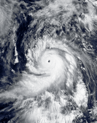
Hurricane Dora, also known as Typhoon Dora, was a long‑lived and powerful tropical cyclone that tracked across all three North Pacific tropical cyclone basins in August 2023. The fourth named storm, fourth hurricane, and second major hurricane of the 2023 Pacific hurricane season, Dora developed on July 31, from a tropical wave that had crossed over Central America from the North Atlantic, and became a tropical storm early the following day. During August 2–3, the system rapidly intensified to Category 4 strength. The same day, Dora moved into the Central Pacific basin from the East Pacific basin. Dora's annular structure deteriorated, leaving the system susceptible to dry air intrusions, and the hurricane passed south of Johnston Island. Dora weakened to Category 3 strength on the morning of August 10.
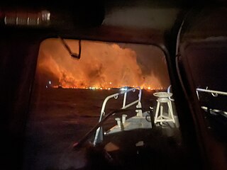
In early August 2023, a series of wildfires broke out in the U.S. state of Hawaii, predominantly on the island of Maui. The wind-driven fires prompted evacuations and caused widespread damage, killing at least 101 people and leaving two persons missing in the town of Lahaina on Maui's northwest coast. The proliferation of the wildfires was attributed to dry, gusty conditions created by a strong high-pressure area north of Hawaii and Hurricane Dora to the south.