Padgate

Last updated

Padgate
Poulton with Fearnhead - Christchurch.jpg
Christ Church
Cheshire UK location map.svg
Red pog.svg
Padgate
Location within Cheshire
Civil parish
Unitary authority
Ceremonial county
Region
Country England
Sovereign state United Kingdom
Post town WARRINGTON
Postcode district WA1, WA2
Dialling code 01925
UK Parliament
List of places
UK
England
Cheshire
53°25′N2°34′W / 53.41°N 2.56°W / 53.41; -2.56
River Mersey in Padgate The quality of Mersey - geograph.org.uk - 109017.jpg
River Mersey in Padgate

Padgate is a suburb of Warrington, in the civil parish of Poulton-with-Fearnhead, in the Warrington district, in the ceremonial county of Cheshire, England.

Contents

History

Overview

Historically part of Lancashire, until 1838 Padgate was an area of farmland in the Fearnhead district. It was only with the establishment of a parish and the building of Christ Church Padgate that a recognisable community arose.

Following boundary changes in 1974, Padgate, along with the rest of Warrington, became part of the county of Cheshire. It is now a largely residential, suburban district. It was the site of an R.A.F training camp and home of a teacher training college, now the Padgate Campus of the University of Chester.

Padgate has a railway station, three churches, a number of schools, a community centre and, next to the railway line, a large area of land and playing fields known as Bennett's Recreation Ground. This was the home of the Woolston Rovers rugby league side and also the Cheshire Cadets Drum and Bugle Corps with their headquarters Kennedy Hall. This is also home to Greenall's Padgate St Oswald's reserves football team of the Mid Cheshire Football League reserve division. Greenall's Padgate St Oswald's first team play at Tetley Walker's Club, Long Lane, Warrington.

The Famous King and Queen pub The Famous King and Queen pub - geograph.org.uk - 27007.jpg
The Famous King and Queen pub

The centre of Padgate (the area around the railway station, Christ Church, the Station House Grill pub (formerly known as The Stocks public house) which is a new build from the 1960s that replaced a much older pub of the same name on the same site, and the community centre) is separated from the main commercial centre by Padgate Lane, which connects the two, approximately three quarters of a mile apart.

Padgate is in the parliamentary constituency of Warrington North.

Geographically the area is on the east side of Warrington. It is north of the River Mersey and enclosed to the east by the M6 motorway. Topographically the land in the area is flat, being in the Mersey valley.

Padgate Brook, a tributary of the Mersey, runs to the western edge of Padgate, and is in turn fed by numerous smaller waterways (Spittle Brook, Blackbrook, Spa Brook, Cinnamon Brook, Cross Brook, Cockshot Burn) originating in Peel Hall Meadows and other outlying rural stretches of land to the north. To the east, Birchwood Brook also feeds the Mersey.

RAF Station

During the Second World War, Padgate had a small RAF Station. It was used as a training camp for National Servicemen after the war. The camp was built on the site of a former Quaker Farm, the entrance to which was situated on Station Road.

The site of the former RAF station was demolished in the mid-to-late 1970s, and has since been largely covered by a housing estate, bordered by Bennett's Rec and the railway line to the south, Fearnhead to the north-east, and Blackbrook and Cinnamon Brow to the north. Padgate Academy is also sited on this land.

The main entrance to the RAF camp was on what is now Station Road North. Although the RAF site is now largely invisible its legacy lives on in local place names - Insall Road running east-west in parallel to the A574 is named after the one-time commanding officer of the site, and the local high school was known from 2009 to 2013 as Lysander Community High, the Westland Lysander being one of the aircraft linked to the former RAF base.

Remnants of the camp's presence can still be seen in some parts of the land, for example the brickwork from the rifle range can still be seen close to the railway footbridge in the south-west corner of the former site.

University of Chester Padgate Campus

The university campus (which despite being known as the Padgate Campus is in fact in the neighbouring village of Fearnhead) belonging to the University of Chester was used as a camp for Canadian servicemen during the Second World War. In 1946, it became a teacher training college and in the late 1960s was re-named to Padgate College of Education. In honour of the historical usage, part of the site was named Canada Hall.

The campus is now home to 384 students. A variety of degree courses are on offer, including degrees in journalism and sport-related subjects. The campus houses an SU bar named bar twenty ten. There are 8 halls of residence and also a residential cul-de-sac called College Close.

The University of Chester announced the closure of the campus on 22 January 2021 outlining intentions to relocate teaching to buildings in Warrington town centre.

Geography

5 kilometres (3 mi) east of Warrington town centre, Padgate lies between the Liverpool and Greater Manchester urban areas. It is 35 kilometres (22 mi) east of Liverpool, 26 kilometres (16 mi) west of Manchester, and 47 kilometres (29 mi) northeast of Chester. [1] The suburb is crossed to the south by the river Mersey and is close to the Manchester Ship Canal. A small tributary of the Mersey, Padgate Brook, runs through it roughly north-south, joining the Mersey to the south.

Main sights

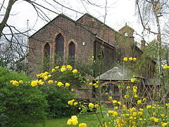
Its parish church, Christ Church (1838), is a listed building, the former rectory (built approximately 2 years later) associated with the church is locally listed. Christ Church has an affiliated Church of England Primary School nearby which also dates, in its present form, from around the same time. In 2016, work commenced on the building of a new vicarage in the grounds adjacent to the church. This new vicarage became the residence of the vicar in early 2017 and the old rectory is now a private residence.[ citation needed ]

There are two other churches in the area: Padgate Methodist Church and St. Oswald's Roman Catholic Church. [2]

Transport

Padgate railway station Padgate railway station in 2009.jpg
Padgate railway station

Padgate has an unstaffed railway station on the Manchester-Liverpool line served by the local stopping service. [3] Up until the mid-1970s, the station was fully staffed and a row of cottages (still extant) next to the station were designed as residences for the station staff.

The M6 motorway is located some km east, and nearest exit is "Warrington-Irlam-A57". The A roads serving Padgate are the A50, A57 and A574. [1]

See also

Related Research Articles

<span class="mw-page-title-main">Cheshire</span> County of England

Cheshire is a ceremonial county in North West England. It is bordered by Merseyside to the north-west, Greater Manchester to the north-east, Derbyshire to the east, Staffordshire to the south-east, and Shropshire to the south; to the west it is bordered by the Welsh counties of Flintshire and Wrexham, as well as a short coastline on the Dee Estuary. Warrington is the largest settlement, and the city of Chester is the county town.

<span class="mw-page-title-main">Runcorn</span> Town in England

Runcorn is an industrial town and cargo port in the Borough of Halton, Cheshire, England. Its population in 2021 was 62,100. Runcorn is on the southern bank of the River Mersey, where the estuary narrows to form the Runcorn Gap.

<span class="mw-page-title-main">Woolston, Cheshire</span> Human settlement in England

Woolston is a settlement and civil parish in the Borough of Warrington in the county of Cheshire, England. Formerly a township called 'Woolston with Martinscroft' within the parish of Warrington, there are two main settlements: Woolston to the west and Martinscroft to the east. Within the boundaries of the historic county of Lancashire, the parish is on the north bank of the River Mersey and takes in Paddington to the south-west. It is bounded by the River Mersey to the south, Bruche and Padgate to the west, Longbarn and Birchwood to the north and Rixton to the east.

<span class="mw-page-title-main">Great Sankey</span> Human settlement in England

Great Sankey is a civil parish in the Borough of Warrington, Cheshire, England. It is 2 miles (3.2 km) west of Warrington town centre and had a population of 24,211 in 2001 Census.

<span class="mw-page-title-main">A57 road</span> Road in England

The A57 is a major road in England. It runs east from Liverpool to Lincoln via Warrington, Cadishead, Irlam, Patricroft, Eccles, Salford and Manchester, then through the Pennines over the Snake Pass (between the high moorlands of Bleaklow and Kinder Scout), around the Ladybower Reservoir, through Sheffield and past Worksop. Between Liverpool and Glossop, the road has largely been superseded by the M62, M602 and M67 motorways. Within Manchester a short stretch becomes the Mancunian Way, designated A57(M).

<span class="mw-page-title-main">A49 road</span> Road in England

The A49 is an A road in western England, which traverses the Welsh Marches region. It runs north from Ross-on-Wye in Herefordshire via Hereford, Leominster, Ludlow, Shrewsbury and Whitchurch, then continues through central Cheshire to Warrington and Wigan before terminating at its junction with the A6 road just south of Bamber Bridge, near the junction of the M6, M65 and M61 motorways.

<span class="mw-page-title-main">Cheadle, Greater Manchester</span> Village in Greater Manchester, England

Cheadle is a village in the Metropolitan Borough of Stockport, Greater Manchester, England. Within the boundaries of the historic county of Cheshire, it borders Cheadle Hulme, Gatley, Heald Green and Cheadle Heath in Stockport, and East Didsbury in Manchester. In 2011, it had a population of 14,698.

<span class="mw-page-title-main">Helsby</span> Human settlement in England

Helsby is a village, civil parish and electoral ward in the unitary authority of Cheshire West and Chester and the ceremonial county of Cheshire, England. Overlooking the Mersey estuary, it is approximately 9 miles (14 km) north east of Chester and 2.5 miles (4 km) south west of Frodsham.

<span class="mw-page-title-main">Culcheth</span> Village near Warrington, England

Culcheth is a village in the civil parish of Culcheth and Glazebury, Cheshire, England, six miles (10 km) north-east of Warrington.

<span class="mw-page-title-main">Padgate railway station</span>

Padgate railway station is a railway station in the Padgate area of the east of the town of Warrington, in North West England. The station, and all trains serving it, are operated by Northern Trains. It is 14 miles (23 km) west of Manchester Oxford Road on the southern route of the Liverpool to Manchester Line.

There are various modes of transport available in Warrington.

Hollins Green is a village on the eastern edge of Warrington, in the Warrington district, in the ceremonial county of Cheshire and historic county of Lancashire, England. The village is in the civil parish of Rixton-with-Glazebrook; the ecclesiastical parish is Hollinfare.

Rixton-with-Glazebrook is a civil parish in the Borough of Warrington, Cheshire, England. Within the boundaries of the historic county of Lancashire, it lies to the east of Warrington and is largely farmland. At the 2011 Census, the parish had a population of 1,960. Its main settlements are the villages of Glazebrook and Hollins Green, and Rixton hamlet.

<span class="mw-page-title-main">Preston on the Hill</span> Human settlement in England

Preston on the Hill is a village and former civil parish, now in the parish of Preston Brook and the unitary authority area of Halton, in Cheshire, England. It is between the villages of Daresbury 1.5 miles (2.4 km) to the north and Dutton 1.1 miles (1.8 km) to the south. The village comprises the hamlets of Windmill Lane, Waterfront, Cotton's Bridge, Tunnel End North, Tunnel Top and Barker's Hollow as well as several farms including White House, Little Manor, New Manor, Windmill Farm and Humble Bee House.

<span class="mw-page-title-main">Borough of Warrington</span> Unitary authority area in Cheshire, England

The Borough of Warrington is a unitary authority area with borough status in the ceremonial county of Cheshire, England. The borough is centred around the town of Warrington, and extends out into outlying villages of Lymm and Great Sankey and the town of Birchwood.

Poulton-with-Fearnhead is a civil parish in the Borough of Warrington in Cheshire, England, containing suburbs to the north and east of the town of Warrington. It contains nine buildings that are recorded in the National Heritage List for England as designated listed buildings, all of which are at Grade II. This is the lowest of the three gradings given to listed buildings, applied to "buildings of national importance and special interest". The parish is almost entirely residential, and includes the Warrington suburbs of Padgate, Fearnhead, Cinnamon Brow, Blackbrook, Longbarn, Bruche and Paddington. The listed buildings are all residential, or related to former farms, other than a church and a milestone.

<span class="mw-page-title-main">Warrington</span> Town in Cheshire, England

Warrington is an industrial town in the borough of the same name in Cheshire, England. The town sits on the banks of the River Mersey and until 1974, was part of Lancashire. It is 19 miles (31 km) east of Liverpool, and 18 miles (29 km) west of Manchester.

<span class="mw-page-title-main">History of Warrington</span>

The history of Warrington began when it was founded by the Romans at an important crossing place on the River Mersey. A new settlement was established by the Saxon Wærings. By the Middle Ages, Warrington had emerged as a market town at the lowest bridging point of the river. A local tradition of textile and tool production dates from this time. The expansion and urbanisation of Warrington coincided with the Industrial Revolution, particularly after the Mersey was made navigable in the 18th century. Warrington became a manufacturing town and a centre of steel, textiles, brewing, tanning and chemical industries.

References

  1. 1 2 30431739 Padgate on OpenStreetMap
  2. "Padgate Chrish Church official website". Archived from the original on 6 January 2017. Retrieved 5 January 2017.
  3. 45020782 Padgate railway station on OpenStreetMap

Commons-logo.svg Media related to Padgate at Wikimedia Commons