
L'Aquila is a city and comune in central Italy. It is the capital city of both the Abruzzo region and of the Province of L'Aquila, Italy. As of 2024, it has a population of 69,902 inhabitants. Laid out within medieval walls on a hill in the wide valley of the Aterno river, it is surrounded by the Apennine Mountains, with the Gran Sasso d'Italia to the north-east.

The province of L'Aquila is the largest, most mountainous and least densely populated province of the Abruzzo region of Italy. It comprises about half the landmass of Abruzzo and occupies the western part of the region. It has borders with the provinces of Teramo to the north, Pescara and Chieti to the east, Isernia to the south and Frosinone, Rome and Rieti to the west. Its capital is the city of L'Aquila.
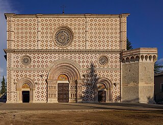
Santa Maria di Collemaggio is a large medieval church in L'Aquila, central Italy. It was the site of the original Papal Jubilee, a penitential observation devised by Pope Celestine V, who is buried there. The church, which therefore ranks as a basilica because of its importance in religious history, sits in isolation at the end of a long rectangular sward of grass at the southwest edge of the town.

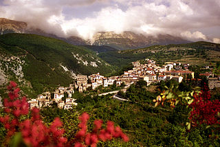
Pacentro is a comune of 1,279 inhabitants of the province of L'Aquila in Abruzzo, Italy. It is a well-preserved historic medieval village located in central Italy, several kilometers from the City of Sulmona about 170 kilometres (110 mi) east of Rome. It is one of I Borghi più belli d'Italia.

Amatrice is a town and comune (municipality) in the province of Rieti, in the Italian region of Lazio, and the center of the food-agricultural area of Gran Sasso e Monti della Laga National Park. The town was devastated by a powerful earthquake on 24 August 2016. It is one of I Borghi più belli d'Italia.
Palena is a comune and town in the province of Chieti in the Abruzzo region of Italy.
Cansano is a comune in the province of L'Aquila in the Abruzzo region, Southern Italy. It is part of the Maiella National Park. Cansano is known for the archaeological discovery of the Italic and Roman town of Ocriticum, which has become an archaeological park.

Fossa is a comune and town in the province of L'Aquila in the Abruzzo region of southern Italy. Bernardino of Fossa was born in the town. The 2009 L'Aquila earthquake contributed to the collapse of a bridge in Fossa, and caused extensive damage to the residential buildings in the town. The town was the epicentre of a major aftershock 5.4 Mw on April 7, 2009.

Poggio Picenze is a comune and town in the province of L'Aquila in the Abruzzo region of Italy. Poggio Picenze is a small city with about 1,000 inhabitants. Located on Italy's Highway 17, it is 14 kilometres (9 mi) from the Abruzzese Apennines and about 12 kilometres (7 mi) from the city of L'Aquila. It sits 760 metres (2,490 ft) above sea level and overlooks the Aquila basin. It is also part of the mountain community of Campo Imperatore-Piana Navelli.

Villa Sant'Angelo is a comune and town in the province of L'Aquila, in the Abruzzo region of Italy, which lies in the Aterno River valley near the convergence of the Sirente and the Gran Sasso mountain ranges. Many of the municipal functions are managed cooperatively with adjacent villages, comprising the Comunità Montana Amiternina.
The 1918 San Fermín earthquake, also known as the Puerto Rico earthquake of 1918, struck the island of Puerto Rico at on October 11. The earthquake measured 7.1 on the moment magnitude scale and IX (Violent) on the Mercalli intensity scale. The mainshock epicenter occurred off the northwestern coast of the island, somewhere along the Puerto Rico Trench.
Eccellenza Abruzzo is the regional Eccellenza football division for clubs in Abruzzo, Italy. It is competed amongst 18 teams and the winner is promoted to Serie D. The clubs that finishes between the second and the fifth place also have a chance to gain promotion. The winner of the regional play-off is entered into a national round which consists of two matches.

An earthquake occurred in the region of Abruzzo, in central Italy, at 03:32 CEST on 6 April 2009. It was rated 5.8 or 5.9 on the Richter scale and 6.3 on the moment magnitude scale; its epicentre was near L'Aquila, the capital of Abruzzo, which together with surrounding villages suffered the most damage. There were several thousand foreshocks and aftershocks since December 2008, more than thirty of which had a Richter magnitude greater than 3.5.
The 1703 Apennine earthquakes were a sequence of three earthquakes of magnitude ≥6 that occurred in the central Apennines of Italy, over a period of 19 days. The epicenters were near Norcia, Montereale and L'Aquila, showing a southwards progression over about 36 kilometres (22 mi). These events involved all of the known active faults between Norcia and L'Aquila. A total of about 10,000 people are estimated to have died as a result of these earthquakes, although because of the overlap in areas affected by the three events, casualty numbers remain highly uncertain.
San Gregorio is a village in the Abruzzo region of central Italy. It is a frazione of the comune of L'Aquila. It sits 584 meters above sea level at the base of Monte Manicola. The village of San Gregorio is 12.11 kilometers from the town of L'Aquila, of which it is considered a suburb community. Italy's SS17 Highway is its main transportation artery. The village sits near an active earthquake fault zone in the Valley of the Aterno-Pescara.

The 2016 Ecuador earthquake occurred on April 16 at with a moment magnitude of 7.8 and a maximum Mercalli intensity of VIII (Severe). The very large thrust earthquake was centered approximately 27 km (17 mi) from the towns of Muisne and Pedernales in a sparsely populated part of the country, and 170 km (110 mi) from the capital Quito, where it was felt strongly. Regions of Manta, Pedernales and Portoviejo accounted for over 75 percent of total casualties. Manta's central commercial shopping district, Tarqui, was completely destroyed. There was widespread damage across Manabí Province, and structures hundreds of kilometres from the epicenter collapsed. At least 676 people were killed and 27,732 people injured. President Rafael Correa declared a state of emergency; 13,500 military personnel and police officers were dispatched for recovery operations.
The following is a timeline of the history of the city of L'Aquila in the Abruzzo, a region of Italy.
On 27 November 1461, a powerful earthquake and series of aftershocks struck Italy's Abruzzo region along the Aterno River. The tremors caused widespread damage to Abruzzo's capital, L'Aquila, and the surrounding villages. At least 80 people are recorded to have died and numerous people were injured by the earthquakes. The quakes also caused major, permanent damage to religious sites and changed politics for L'Aquila and the Abruzzo region.
On 9 September 1349, an earthquake sequence began in Italy's Apennine Mountains that severely affected the regions of Molise, Latium and Abruzzo. Probably four moderate-large earthquakes devastated towns and villages across the central Italian Peninsula, with damage even reported in Rome. These earthquakes originated from the Apennine fold and thrust belt fault network, with the first and most destructive shock's epicenter originating from the north-west Campania region. Paleoseismological data gathered from scarping, fault length, and collapsed sections of Venafro's Roman aqueduct indicates the epicenter of the main shock was likely along the Aquae Iuliae fault. The fault suspected of causing this earthquake occurred on the Aqua Iuliae fault along the Molise-Campania border.
The 1706 Abruzzo earthquake, also known as the Maiella earthquake, occurred on November 3 at 13:00 CEST. The earthquake with a possible epicenter in the Central Apennine Mountains (Maiella), Abruzzo had an estimated moment magnitude of 6.6–6.84 Mw . It was assigned a maximum Mercalli intensity of XI (Extreme), causing tremendous destruction in Valle Peligna. At least 2,400 people were killed.

