
Garrick's Villa is a Grade I listed country house located on Hampton Court Road in the London Borough of Richmond upon Thames. Its park and gardens are listed at Grade II by Historic England in the Register of Historic Parks and Gardens of special historic interest in England.

The Bull & Gate is a Grade II listed public house at 389 Kentish Town Road, Kentish Town, London.

High Town is a hilly inner-city area of Luton adjacent to Luton railway station. The area is roughly bounded by Richmond Hill and the northern edge of People's Park/Pope's Meadow to the north, the Midland Main Line to the south, the A6 to the west, and Hitchin Road to the east.

The Hope and Anchor is a Grade II listed public house at 20 Macbeth Street, Hammersmith, London.

The Ye Olde Mitre is a Grade II listed public house at 1 Ely Court, Ely Place, Holborn, London EC1N 6SJ.

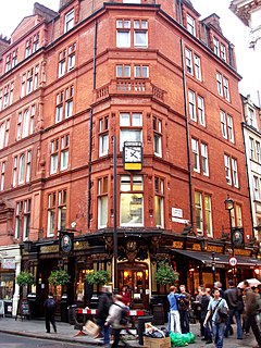
The Argyll Arms is a Grade II* listed public house at 18 Argyll Street, Soho, London, W1.

The Dog and Duck is a Grade II listed public house at 18 Bateman Street, Soho, London W1D 3AJ, built in 1897 by the architect Francis Chambers for Cannon Brewery.

The King's Head is a Grade II listed public house at 84 Upper Tooting Road, Tooting, London SW17 7PB.
The Salisbury is a Grade II listed public house at 91–93 St Martin's Lane, Covent Garden, London which is noted for its particularly fine late Victorian interior with art nouveau elements.

The Black Lion is a Grade II* listed public house at 274 Kilburn High Road, Kilburn, London.

The Flying Horse is a Grade II* listed public house at 6 Oxford Street, Fitzrovia, Westminster. It was built in the 19th century, and is the last remaining pub on Oxford Street. The pub is on the Campaign for Real Ale's National Inventory of Historic Pub Interiors.

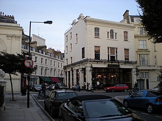
The Victoria is a Grade II listed public house at 10a Strathearn Place, Bayswater, London W2 2NH.
The Prince Alfred is a Grade II listed public house at 5a Formosa Street, Maida Vale, London, W9.

The Lord Nelson is a Grade II listed public house at 386 Old Kent Road, Bermondsey, London.
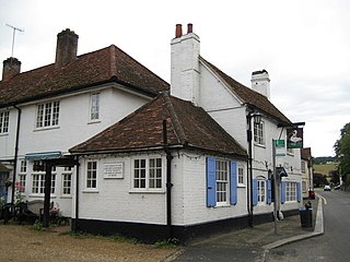
The Swan is a Grade II listed public house at High Street, West Wycombe, Buckinghamshire.

The Queens Arms is a Grade II listed public house at Hartfield Road, Cowden Pound, Kent TN8 5NP.

The Red Lion is a Grade II listed public house at 2 Duke of York Street, St James's, London, SW1.

The Mason's Arms is a pub on Battersea Park Road, Battersea, London SW8, situated opposite Battersea Park Railway Station.
The Markham Arms is a former pub at 138 King's Road, London SW3. It closed as a pub in the early 1990s, and is now a branch of the Santander bank.
The Great Northern is a pub at 63 Bute Street, Luton, Bedfordshire. The 19th century building is Grade II listed.
