The area of South Velebit has been inhabited since prehistoric times. It is believed that, during the last ice age, the area was probably inhabited by small groups of Paleolithic hunters/gatherers, as elsewhere in the Mediterranean. Sea level must have been 120 metres (390ft) lower than today, and the Velebit Channel was a wide valley with a river flowing through it. The highest parts of the Velebit were covered with glaciers. When sea level began to rise in the late ice age, people moved to higher, hilly areas. The earliest records of humans in Velebit – Mesolithic flint tools found in Vaganačka Cave under Veliko Rujno – date back to this era.
Approximately eight thousand years ago, the first cattle breeders and farmers arrived in the area, bringing wheat, domestic goats and sheep, as well as the knowledge of their breeding. Hunter-gathering lost its importance, and livestock-rearing began on Velebit. Plenty of material evidence, such as bones of domestic animals, tools and equipment used by prehistoric shepherds and decorated clay tableware, was found in the caves that served as shelter for people and cattle.
Velika Paklenica gorgeAn underground military complex in Paklenica was built between 1950 and 1953, at the height of tensions between Yugoslavia and the Soviet Union, and remained a closely guarded secret until 1991. Since 2016, it is a visitor center open to the public, and dedicated to mountain climbing.
During the last two thousand years BC, during the Bronze Age, the first fortifications and stone buildings were erected by Liburian peoples. They could serve as shelter to the population from the surrounding villages in case of danger, and some of them may have been permanent settlements where the local rulers had their seats. In addition, they oversaw important cattle and trade routes leading to Velebit and further to Lika via Paklenica or Rujan. Some of them served to oversee navigation. They are now destroyed, but ring-shaped mounds ("gromila", pl. "gromile") up to several meters in height can still be seen in some places. In the immediate vicinity of the fortifications, casket heaps – deposits of large round stone under which former rulers were buried in caskets made of stone tablets – have been found. Most of them have been dug out and the graves robbed, but they are still visible, as in the area of hamlet Ljubotić in Tribanj.
Over the last two thousand years BC, the east coast of the Adriatic was gradually conquered by the Roman legions. After the Roman province of Dalmatia was founded in the early 1st century AD, permanent Roman reign was established. Starigrad (Roman name: Argyruntum) was established at the time, and it soon developed into an important trading center. In the 4th century AD, Emperor Tiberius had it fortified with walls and towers. The town cemetery was situated by the road that led southwest of the town. Plenty of archaeological findings were collected from approximately 400 explored graves – jewelry, glassware and metalware, weapons and tools. The most interesting finding is certainly the ancient glass collection – as many as 146 vessels of different forms (bowls, glasses, bottled) – kept in the Zadar Museum of Archeology.
Life in Argyruntum came to a standstill in the early 4th century AD. The era of peace was interrupted by attacks of tribal peoples that contributed to the decline of the Roman Empire in the west. In an attempt to bring the Adriatic coast back into the Empire, East Roman Emperor Justinian built a system of fortifications to secure navigation and protect the local population. The ruins of forts and towers above Modrič and near Sveta Trojica in Tribanj are parts of this defensive system that briefly postponed the final decline of the ancient world in the Adriatic.
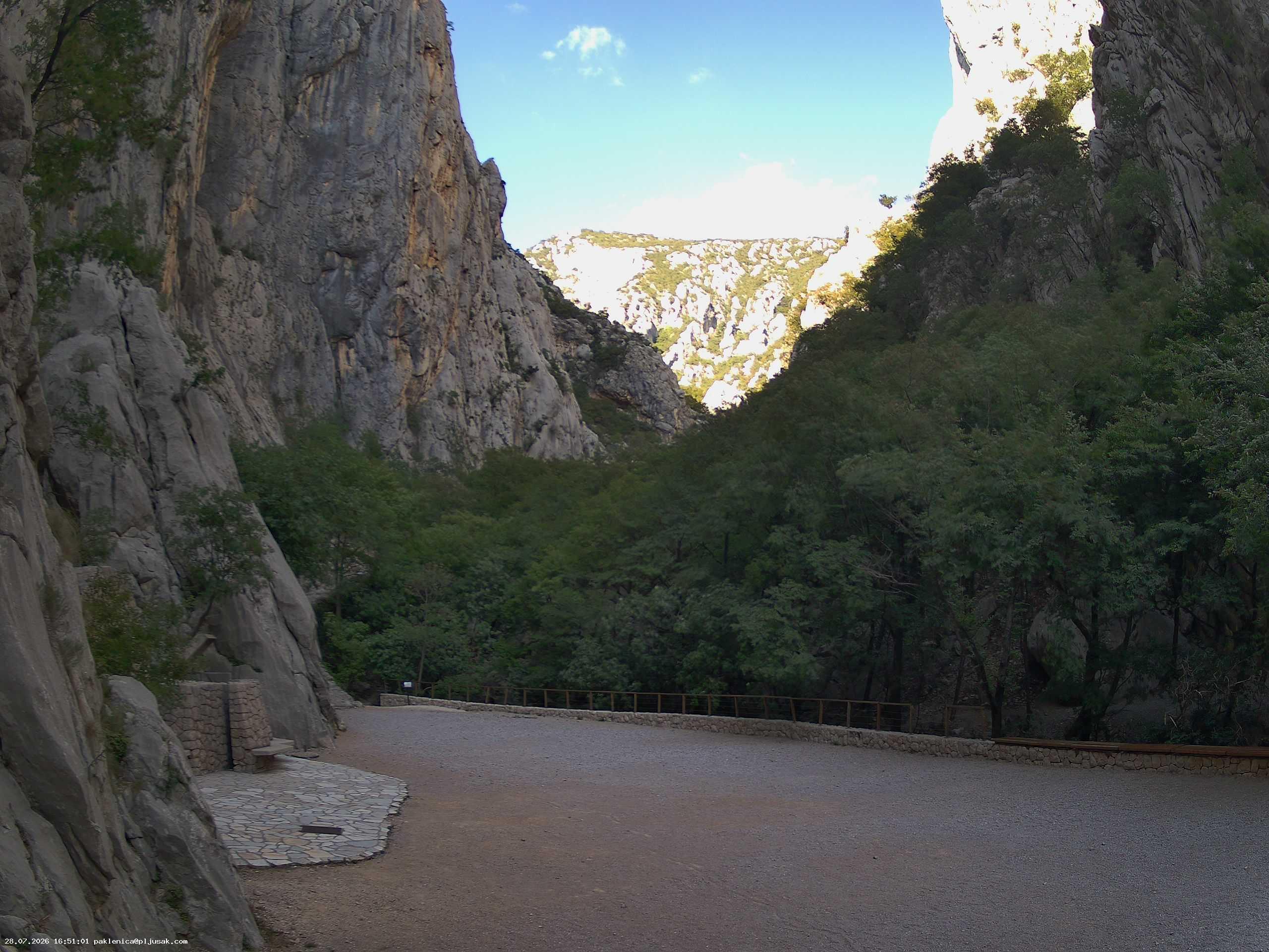
Paklenica seen from RažanacPaklenica interior
The arrival of Croats in this area began in the early Middle Ages. The earliest preserved traces of their presence are the chapels, St. George (Sv. Juraj) in Rovanjska, St. Peter (Sv. Petar) in Starigrad, and St. Mary Magdalene (Sv. Marija Magdalena or Trstenica) built from the 9th or 12th century AD.[2] Two forts – Večka Kula and Paklarić – were probably erected in the late Middle Ages (14th–16th century).
Anića kuk (712 m/2350 ft) has some of the best-known big wall routes in the canyon
On 27 June 1938, Dragutin Brahm died during an attempted ascent of Anića kuk.[3]
Near the entrance to the Velika Paklenica is an artificial tunnel complex built for Josip Broz Tito during the tension between Yugoslavia and the USSR in the late 1940s and early 1950s.
On 17 July 1957, Boris Kulić and Boris Kambič of HPD Mosor ascended Mosoraški (5c) on Anića kuk, with only ropes untied from their mothers' clothes lines and homemade pitons as protection.[6]
The 1st Yugoslav alpine climbing gathering in Anića luka was held on Labor Day in 1959.[7]
On 4–8 October 1966, Miroslav Pleško, Stanislav Gilić, and Nedjeljko Jakić of PDS Velebit ascended Klin (6c+) on Anića kuk. The ascent took 5 days.[9]
From 26 April through 3 May 1973, Borislav Aleraj and Marijan Čepelak ascended the 350 metres (1,150ft)Brid Klina[a] (7b+) on Anića kuk. The multi-pitch climb took them 8 days (then a regional record), and made national news. With an aid climbing grade of A3/A4, it was also the hardest routes in the region. Its first repeat came in 1986, by Srečo Rehberger and Tadej Slabe[sl]. It was repeated again in 1987 by Czechs P. Čermák and Z. Konečný. Other well-known repeaters include Boris Čujić and Martina Čufar Potard.[b] The climb to the base of the Klin is an easy 4/5. The first pitch along the Brid is a long 7b that can be separated into multiple pitches (7b, 6c+, 6b, 6a, 5c). A 6b/7a pitch follows. The next two pitches are both 7b+ and make up the crux of the route. The Klin is then abandoned for a 4c top out.[10]
The first ascent of Šaleški smjer (4c) on Anića kuk was made by D. Kukovec and J. Resnik. At one point, Franček Knez[sl] set a speed record of 11min on the route.[11] Knez was very active in Paklenica in the 1970s, climbing approximately 40 routes, including some of the hardest free ascents at the time, such as Kača (6a) on Anića Kuk, which he climbed together with Jože Zupan.[12] One time when Boris Čujić was climbing the 120 metres (390ft)Domžalski smjer (6a), Knez was overtook him. While he was about 10 metres (33ft) below, Knez asked Čujić, "is it going [well]?" (Serbo-Croatian: jel' ide?), to which Čujić replied it was (Serbo-Croatian: ide); Knez followed up with, "the important thing is that it is going" (Serbo-Croatian: glavno da ide), now 10 metres (33ft) above.[13]
The climbing school of PDS Velebit used to take place in Paklenica during the gathering. It was during one such school on the Labor Day of 1980 that Boris Čujić, later one of the canyon's most prolific first ascenders, first climbed in Paklenica. Anića luka was full of tents, as it was the 22nd Yugoslav alpine climbing gathering,[14] and camping there was still allowed in those days. Many climbers were camping in the rock shelters along the path, as the meadow itself would fill up, sometimes with over a hundred tents. That year, the Velebitaši[c] followed Belgrade climbers up Brid Klina on Anića Kuk. Back at camp, stories of Franček Knez and Jan Sabolek's ascents took preeminence, as the best climbers in attendance.[15]
In 1984, Silvo Karo, Janez Jeglič[sl] made the first ascent of the 350 metres (1,150ft) long Spomin (8c) on Anića kuk, whose current route was modified with the addition of a direct exit in 1985 when joined by Franček Knez. Its first free ascent was by Luka Krajnc on 10 May 2017 after 27 days of redpointing, with Ena Vrbek as his partner. To date, no one has climbed the full overhang of the Klin; Spomin being the closest yet. Krajnc rated the most difficult pitch 8c, the second most difficult 8b+, two 8a+, and the rest of the route reaches 7b+.[16] Later, on 10 May, Lindič would complete a free ascent of the 350 metres (1,150ft)Mjesečina (7c+).[17]
In 1987, Maurizio Zanolla climbed Il Maratoneta (8b+), which remains Paklenica's most difficult sport route, repeated only thrice as of 2020.[18]
In 1989, Paklenica's most difficult aid route was climbed by Miha Praprotnik and Matjažt Ravhekar, Jogananda (7c), at the time given the grade A4.[19]
In 1990, Yves and Claude Remy visited Paklenica, climbing Rajna (7a) and Wellcome (7b+).[20]
In 1998, Boris Čujić and Ivica Matković renovated the climbing route equipment and bolted a number of new routes on behalf of the National Park Paklenica.[21]
On 12 April 2009, Luka Lindič completed the first free ascent of the 240 metres (790ft)Tango vertikal (7a+), first aid climbed by S. Karo and Silvo Karo in the mid-1980s. Karo was Lindič's partner when he climbed the route in 2009. He had just completed the first free ascent of the 250 metres (820ft) route Življenje (7a) on the 10th, likewise with Karo as his partner.[22]
Geological features
Vodarica cave in Mala Paklenica
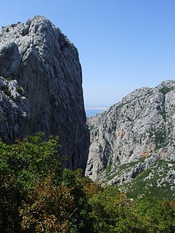
The most attractive and most valuable parts of South Velebit are surely the impressive canyons of Velika Paklenica and Mala Paklenica. Velika Paklenica canyon is 14km long and 500–800 m wide. In its narrowest part around the Bunkers, the canyon is only 50 m wide. Vertical cliffs rise above both sides of the canyon up to a height of over 700 m. The most attractive part is the area around the steep drop of the stream downstream from Anića luka, where steep cliffs rise directly above the stream, forming the narrowest part of the canyon between Anića luka and the parking lot. Mala Paklenica Canyon is of lesser dimension, and the torrent running through it is much less powerful. It is 12km long and 400–500 m wide. In its narrowest part, it is only 10 m wide, while the surrounding cliffs rise up to a height of 650 m.
The central part of the Park is distinctive for the relief complex of Borovnik and Crni vrh, with the valley of Mala Močila and Velika Močila nearby. In terms of relief, Velika Močila is a very interesting bowl-shaped valley at an altitude 850 m asl, surrounded by Crni vrh (1 110 m asl), Škiljina kosa (1 015 m asl) and Zeleni brig (842 m asl), while Borovnik, named after the black pine forest, stretches along the south edge.
The east part of the Park is very differentiated geomorphologically, inaccessible and wild. Further to the east, this zone of wilderness transforms into an area of milder forms around Malo Libinje and Veliko Libinje, karstic plateaus with numerous pits, the bottoms of which were mostly treated.
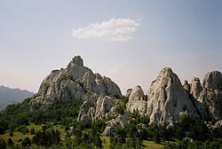
The highest area of Paklenica National Park is the narrow ridge of Velebit, 1 to 3km wide. The highest peak of Velebit – Vaganski vrh (1 757 m asl) is also here. The area of Paklenica National Park is one of the most completely explored areas in Croatia in terms of speleology. 76 speleological objects are known and have been explored in the Park, namely 39 pits and 37 caves. We will mention some of the most interesting speleological objects in the National Park. Vodarica Pit is the longest cave in Velebit at 300 meters, Precipice on Bunovac (534 m) is the deepest object in Central and South Velebit.
Watertight sediments are situated beneath very porous karstic deposits of carbonate rock in the extended part of Velika paklenica, Brezimenjača, and in the spring parts of Mala paklenica and the occasional flow of Orljača. This is why Paklenica National Park has several permanent or occasional flows and many permanent springs. The permanent springs of high-quality drinking water are Stražbenica, Kontinovo vrilo, Crno vrilo, Velika Močila and Pećica.
Today there is no water flowing through Mala Paklenica.
Flora
The wealth of flora is reflected in the list of 1,000 plant species and subspecies recorded to date, 79 of them endemic. The great diversity, the presence of relict, endemic, rare, statutorily protected species make the Park a very valuable floristic area, not just in Croatia, but in Europe and the world as well.
The forest phenomenon is one of the main reasons why the South Velebit area was proclaimed a national park. Areas of oak and oriental hornbeam forests, beech forest, black pine forests, and fern forest, can all be found in the park. In 2017, the beech forests within the national park were added to the UNESCOWorld Heritage Site known as Ancient and Primeval Beech Forests of the Carpathians and Other Regions of Europe because of their testimony to the ecological history of forest dynamics within Europe since the last Ice Age.[23]
Fauna
The diverse habitats in Paklenica and the vertical stratification provide home to a diverse fauna. Invertebrates are relatively poorly explored, attractive insects like diurnal butterflies are well explored. Over 40 species of amphibians and reptiles are found, the endangered Orsini's viper is a highlight.
Birds are the most numerous group of vertebrates, with 230 species recorded to date. The world of birds is represented by 102 species of nesting birds found in the broader park area. The nesting bird group includes a community of birds inhabiting rocks and cliffs in the canyons of Velika Paklenica and Mala Paklenica, with 24 bird species. A special value is added to the park by the endangered and rare bird species such as the golden eagle, peregrine falcon, short-toed eagle and goshawk. Forest areas are rich with woodpeckers, the rarest among them being the white-backed woodpecker and middle spotted woodpecker.
There are also 53 species of mammals at the park, the roe deer and chamois are highlights, while the brown bear is the biggest predator. In the caves there is a host of interesting underground animals such as crabs, mites, Nematodes, aquatic worms, spiders, pseudoscorpion, beetles and bats.
Tourism
A Trail in Paklenica
Hiking is the only way to really get to know Paklenica. The Park area contains 150–200km of trails and paths, from those intended for tourists, leading from Velika Paklenica Canyon to Manita peć cave, Lugarnica forest cottage and the mountain hut, to those intended for mountaineers, leading to the highest peaks of Velebit. The trails in the Park are marked with boards and mountaineering signs.
Paklenica National Park is the most visited climbing site in Croatia, and the largest in Southeast Europe. The close proximity of seawater gives this climbing site a special charm, making Paklenica Riviera an ideal place to combine climbing and water sports. Today, there are over 360 equipped and improved routes of various difficulty levels and lengths within Paklenica's climbing sites, so each climber can find to their liking. The main climbing season begins in spring and goes on until late autumn.
Mountain huts
In the 1935–1936 season, the mountain shelter on Struge, at 1,320 metres (4,330ft) in elevation, saw 25 visitors.[24]:224 In the 1936–1937 season, no data was released, but it was open year-round,[25]:243 as in the 1937–1938 season.[26]:243
This page is based on this Wikipedia article Text is available under the CC BY-SA 4.0 license; additional terms may apply. Images, videos and audio are available under their respective licenses.


