Related Research Articles

Vehari also spelled Vihari, is a city and the headquarters of Vehari District in the Punjab province of Pakistan. It is Pakistan's 62nd largest city. Vehari is about 100 km (62 mi) from the historical city of Multan. Vehari is located at the Multan-Delhi Road constructed by Emperor Sher Shah Suri. It is at an altitude of 135 m (443 ft).,{Peer Murad Colony Vehari chak No 65.kb}

The Swat River is a perennial river in the northern region of the Khyber-Pakhtunkhwa Province of Pakistan. The river's source is in the high glacial valleys of the Hindu Kush mountains, where it then flows into the Kalam Valley before forming the spine of the wider Swat Valley.

Chashma Barrage is a barrage on the River Indus in the Mianwali District of the Punjab province of Pakistan. It is 304 km northwest of Lahore and 56 km downstream of Jinnah Barrage. The contract for Chashma Barrage works was awarded on 10 February, 1967, to French Consortium Société Dumez and Société Borie and was successfully completed by 25 March, 1971. The total cost of Chashma Barrage works was Rs.399 million but power generation started later in 2001. The installed capacity of power station is 184 MW, from eight Kaplan-type bulb turbine units, each with a 23 MW capacity. The bulb turbines have been installed for the first time in Pakistan. The first unit was commissioned in January 2001, while final commissioning of all units was completed in July 2001. The 8 Kaplan-type turbines and synchronous generator units were made by Fuji, Japan.

Budameru is a rivulet in NTR district which originates in the hills surrounding Mylavaram and empties itself into Kolleru Lake. Budameru is also known as The Sorrow of Vijayawada. In order to control the floods, the rivulet was controlled with the Velagaleru Regulator at Velagaleru village and a diversion channel named, Budameru Diversion Channel (BDC) was constructed from Velagaleru to join Krishna River upstream of Prakasam Barrage.
Khanki Headworks is a headworks situated on the River Chenab in Gujranwala District of the Punjab province of Pakistan. The construction of this headworks was completed in 1889 and was one of the oldest headworks in Pakistan.
Marala Headworks is a headworks situated on the Chenab River near the city of Sialkot in Gujrat district in Punjab, Pakistan. A weir was first built during 1906–1912 in the British India to feed the Upper Chenab Canal, as part of the 'Triple Canals Project'. A new Marala Barrage was constructed in 1968 to feed the Marala–Ravi Link Canal in addition to the original Upper Chenab Canal.

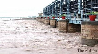
The Islam Headworks, commonly known as Head Islam, is a headworks on the River Sutlej in Hasilpur Tehsil of the Punjab province of Pakistan. It is used for irrigation and flood control.

Taunsa Sharif is a city in Punjab province of Pakistan. It is the capital of Taunsa District. Taunsa Sharif is primarily inhabited by Balochi speaking and Saraiki Speaking Baloch descent people. It is situated on the bank of River Indus. Taunsa is an agricultural area known for its fertile land and crops.
Rasul Barrage is a barrage on the River Jehlum between Jhelum District and Mandi Bahauddin District of the Punjab province of Pakistan. It is situated 72 km downstream of Mangla Dam.

The Bhimgoda Barrage, also referred to as the Bhimgoda Weir or Bhimgoda Head Works, is a barrage on the Ganges River at Har ki Pauri near Haridwar in Haridwar district, Uttarakhand, India. Built as the headworks of the Upper Ganges Canal, an initial barrage was completed by 1854 and replaced twice; the final one completed in 1983. The primary purpose for the barrage is irrigation but it also serves to provide water for hydroelectric power production and control floods. The area behind the barrage is known as the Neel Dhara Bird Sanctuary and is a popular destination for various waterbirds and tourists.
Sulemanki Headworks is a headworks on the River Sutlej in Sulemanki Village, near Depalpur City in Okara district of the Punjab province of Pakistan.

The Narmada Canal is a contour canal in Western India that brings water from the Sardar Sarovar Dam to the state of Gujarat and then into Rajasthan state. The main canal has a length of 532 kilometres (331 mi). It is the second longest canal in India and the largest canal by water carrying capacity. The main canal is connected with 42 branch canals providing irrigation to 2,129,000 hectares farmland. The canal is designed to transfer 9.5 million acre-feet water annually from the Narmada Basin to areas under other river basins in Gujarat and Rajasthan..

Bunga Hayat is a small town in Pakpattan District, Sahiwal Division, Punjab, Pakistan, having a population of 10,000. It is named after Mian Hayat Maneka, an ancestor of the Maneka Family. Prominent politicians from the area are Mian Khudayar Khan Maneka, elected twice as the MLA before partition. Mian Farrukh Mumtaz Maneka (MPA) Mian Khurram Mumtaz Maneka (UC Nazim) and Mian Asadullah Mumtaz Maneka(Ex.District Naib Nazim Pakpattan) Mian Muhammad Yar khan Maneka (Member Zilla council 2 times ) and Mian Mimshad Ahmed Maneka (Member zilla council) Their father Mian Mumtaz Maneka was also an influential political leader of the area. Among 28 Union Councils of Tehsil Pakpattan, Bunga Hayat Union Council is UC-03. UC Bunga Hayat Consists of Bunga Hayat, Nanakpur, Asadullah, Arazi Amar Singh, Magan Pur, 5 Marla Scheme & 7 Marla Scheme.
Western Yamuna Canal is canal in river Yamuna that was dug out and renovated in 1335 CE by Firoz Shah Tughlaq. In 1750 CE, excessive silting caused it to stop flowing. The British raj undertook a three-year renovation in 1817 by Captain GR Blane of the Bengal Engineer Group. In 1832-33 Tajewala Barrage dam at Yamunanagar was also built to regulate the flow of water, and later Pathrala barrage at Dadupur,Yamuna Nagar and Somb river dam downstream of canal were constructed in 1875-76. In 1889-95 the largest branch of the canal Sirsa branch was constructed. The modern Hathni Kund Barrage was built in 1999 to handle the problem of silting to replace the older Tajewala Barrage.
The Pakpattan Hydropower Plant is a small hydro, low head project of 4.2 metres, located in the Pakpattan District on the Upper Chenab Canal, in Punjab, Pakistan. It is approximately 245 km from the provincial capital of Lahore.
Left Bank Outfall Drain is a drainage canal in Pakistan. Built between 1987 and 1997 using funding from the World Bank, the canal collects saline water, industrial effluents and Indus river basin floodwater from more than two million hectares of land of Shaheed Benazirabad, Sanghar, Mirpurkhas and Badin districts located in Nara River basin into the Arabian Sea.
The Punjab Irrigation Department is a provincial government department responsible for irrigation in the Punjab province of Pakistan. It irrigates 21 million acres (8,500,000 ha) of the agricultural land in the province.

The Lower Bari Doab Canal is a canal in Punjab, Pakistan. Part of the part of the second-largest irrigation system of the province, it serves approximately 275,000 farmsteads. It is located south-west of Lahore and runs alongside the River Ravi.

Upper Swat Canal is an irrigation canal located in the Khyber Pakhtunkhwa province of Pakistan. The canal takes off from Swat River at Amandarra Headworks in Malakand District. It irrigates a large area in the north of Mardan District, Swabi District and the north-eastern portion of the Charsadda District. The irrigation area is 276,000 acres of land and discharge is 1,800 cusecs. The length of the main canals is 138 miles and that of the distributaries is 431 miles.
References
- ↑ "PIAIP6 - PAKPATTAN CANAL AND DISTRIBUTION SYSTEM". www.piaip6.com. Retrieved 10 May 2017.
- ↑ "2.82 megawatt power plant to be set on Pakpattan Canal" . Retrieved 5 September 2017.
| | This Pakistan location article is a stub. You can help Wikipedia by expanding it. |