There is a missionary run school called St. Xavier's,[2] which ranked as one of the top two schools in Sikkim during the 1990s. Notable among its alumni are the Padma Shri awardee footballer Baichung Bhutia, who captain India.
The existence of British bunkers at British Killa suggests the presence of armed bunkers sometime in the past.
The name Pakyong comes from the Lepcha words pa yong meaning "bamboo of the bow", as it was a common practise of the Lepchas to name a place after the essential items found at a place.
On 24 September 2018, Prime Minister Narendra Modi inaugurated Pakyong Airport. Regular air service started on 4 October 2018.
Geography
Located in East Sikkim at an altitude of 1,700 metres (5,600ft),[clarification needed] it shares its borders with Bhutan and Tibet. Topography is hilly and a good agricultural area.
The villages surrounding Pakyong are Namcheybong, Ganchung, Kaputhang, Raigoan, Pachey, Samsing, Dikling, Tareythang, Pacheykhani, Pachak, Bering, Bering, Dugalakha, Linkey, Parkha, Machong, Daamlakha, Chalamthang, Barapathing, Changeysenti, Amba, Mamring, Baasilakha and Karthok.
Economy
The local economy is confined to the school and minor local businesses. Ginger is cultivated and floriculture is popular. The geography makes this viable. Goondruk, Kinema, Sinki are popular fermented foods sold in the local market. "Dalle Khorsani" (red chili) is popular among the local vegetable cultivators. Cow milk, curd, Chhurpi (residue of boiled buttermilk) are other means of earning income.
The town is well connected to all major parts of Sikkim and its neighbouring states. Direct Taxi and Jeep services access almost all cities and towns of Sikkim and cities/towns of West Bengal like Siliguri, Kalimpong, Jaigaon, Birpara, Panitanki, Malbazar, Bagdogra etc.
In Pakyong, NH-717A is joined by the Following major roads:
Frequent SNT buses connecting Gangtok via Ranipool are available from the town after every half hour. SNT buses connecting Rongli, Rhenock, Rorathang to Gangtok also runs via Pakyong.
Pakyong Greenfield Airport has two parking bays and a terminal building, which can handle about 100 passengers at a time. The airport is located on top of a hill above Pakyong at 4,500 feet (1,400m) above sea level and it is spread across over 201 acres. The entire airport, including the runway, has been built on land which was itself created by building an embankment wall as high as 263ft in deep valleys.[4]
Demographics
Ethnic Nepalis, who settled in the region during British rule, comprise the majority of the population. Lepcha, native to the land, and Bhutias also constitute a sizable portion of the populace. Immigrant resident communities not native to the region include the Marwaris who form the backbone of the business community and own most of the shops; the Biharis who work in various trades, Bengalis involved in carpentry.
Thanks to the school, the town has attracted a cosmopolitan population with people from as far south as Kerala and Tamil Nadu.
Culture
Nepali (Sikkimese) is the most widely spoken language. English and Hindi are understood in most parts of the state. Other languages include Bhutia (Sikkimese), Tibetan and Lepcha(Sikkimese).
It is common to see school kids walking with guitars strung on their backs. WesternHip-Hop music is popular. Football and cricket are the two most popular sports and the St Xavier's School ground serves as the tournament venue, most notably the Independence Day Cup, which have in the past featured teams from as far as Calcutta, Nepal and Bhutan.
Local favourites like momo, Sel roti, Kheer, thukpa, Paratha, chowmein, Samosa, Kachori, gyathuk and wonton are available in restaurants. Momo is a popular snack, with vegetables, chicken filling steamed and served with soup. The hills traditionally have a liberal attitude towards alcohol and in many of the local functions like marriages etc., it plays an important role. A common local beverage is raksi.
Attractions
Attractions include Dikling mane-lakhang, Shivalaya temple, Pacheykhani cave, Changey monastery, Pakyong Greenfield Airport, Devi Mandir, Karthok Monastery and a Monks’ Retreat Centre. Wednesday bazaar 'haat' is popular.
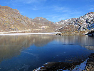
RDD complex is surrounded by pine trees and a small park. Trekking is available in Jhandi dara, located at the topmost part of Pakyong. Nearby Noab gaon is also called the virgin valley and is the hill whose top is the British killa.
Education
St. Xavier's School, JNV Pakyong, Dikling Sr. Sec School, Pakyong Bazar JHS, Pachey Senior Secondary School educate students. Pakim Palatine College provides higher education to local students and students from towns such as Gangtok, Rorathang, Rhenock, Ranipool and from Bhutan. Puspanjali school is one of the best developing autonomous educational institutions. Schools educate children in village areas too. Government Senior Secondary School Mamring was established in 1952.
Others
Pakyong Police Station of Pakyong in Pakyong District of Sikkim is ranked seventh among the top ten best performing police stations in the country according to a survey conducted by the Ministry of Home Affairs, Government of India in 2020.[5]
Related Research Articles
Sikkim is a state in northeastern India. It borders the Tibet Autonomous Region of China in the north and northeast, Bhutan in the east, Koshi Province of Nepal in the west, and West Bengal in the south. Sikkim is also close to the Siliguri Corridor, which borders Bangladesh. Sikkim is the least populous and second-smallest among the Indian states. Situated in the Eastern Himalaya, Sikkim is notable for its biodiversity, including alpine and subtropical climates, as well as being a host to Kangchenjunga, the highest peak in India and third-highest on Earth. Sikkim's capital and largest city is Gangtok. Almost 35% of the state is covered by Khangchendzonga National Park – a UNESCO World Heritage Site.
Gangtok is the capital and the most populous city of the Indian state of Sikkim. The seat of eponymous district, Gangtok is in the eastern Himalayan range, at an elevation of 1,650 m (5,410 ft). The city's population of 100,000 consists of the three Sikkimese ethnicities the Bhutias, Lepchas, Gorkhalis and also plainsmen from other states of India have settled here. Within the higher peaks of the Himalayas and with a year-round mild temperate climate, Gangtok is at the centre of Sikkim's tourism industry.
Gangtok District is an administrative district of the Indian state of Sikkim. It was renamed in 2021 as a result of administrative reorganisation of the state, which also saw three subdivisions of the East Sikkim district spawned off as a separate Pakyong district.
Rangpo is a Municipal town in Pakyong district in the Indian state of Sikkim. The town borders West Bengal's Kalimpong district and is situated along the Teesta river and Rangpo River. It is the first town of Sikkim lying on National Highway 10 that links Siliguri to Gangtok. It is about 300 m above sea level with a sub-tropical climate. It is the 'Gateway to Sikkim' and all vehicles entering Sikkim have to stop at the Rangpo Police check-post. Foreign tourists require documents to enter Sikkim state and have to show them at the police check post.
River Rangpo is a river in the Indian state of Sikkim. A tributary of the Teesta River, it originates from Menmecho Lake near Dzuluk and flows through Rongli and Pakyong subdivision villages in Pakyong District towards Rorathang, Kumrek and Rangpo. The river demarcates the border between Pakyong District of Sikkim and Kalimpong district of West Bengal from Rorathang to Rangpo. At the town of Rangpo, the river joins river Teesta. The Rangpo is the third largest river of Sikkim after Teesta and Rangeet. Atal Setu Bridge the longest roadway bridge of Sikkim is over River Rangpo.
Singtam is a town which lies mostly in Gangtok District and partly in Pakyong District in the Indian state of Sikkim about 30 kilometres (19 mi) from the state capital Gangtok. The town lies on the banking of the rivers Teesta and Ranikhola, which join together just below the town. NH10 and NH510 meet in Singtam. The Indreni Bridge and Sherwani Bridge over the river Teesta are in the town. Singtam District Hospital, the district hospital of Pakyong District, lies at Golitar, Singtam.
Aritar is a region in the Pakyong District under Rongli Sub-Division of the Indian state of Sikkim.
Rhenock is a town, just 35 km from Pakyong City in the Pakyong district in Sikkim, India, located on the border with the Kalimpong district of West Bengal. It lies 63 kilometres east of Gangtok, and 47 kilometres north of Kalimpong on the way to Jelepla Pass at an altitude of 1,040 metres. The word Rhe-nock means Black Hill. Situated in the extreme east of Sikkim, Rhenock witnessed the establishment of the first police outpost in the state.
Ranipool is a small suburban town located in the bank of river Ranikhola at the junction of National Highway 10 and National Highway 717A in Gangtok District of the Indian state of Sikkim. It is 12 km before from Gangtok main town. It has three roads which lead to Singtam, Pakyong and Gangtok. It falls under the Gangtok Municipal Corporation. It is named after the Bridge which Connects the National highway to Gangtok and holds quite a significant role in traffic communications.
Rorathang is a town situated in the bank of Rangpo River on National Highway-717A, in Pakyong District of Sikkim, India.
Tareythang is a village located in Pakyong sub division at the Pakyong District of Sikkim state in India. This village is about 1250 m above sea level with a sub-tropical climate. It is around 11 kilometers away from district headquarter Pakyong. In electoral roll of 2011, Tareythang comes under the Assembly Constituency of Chujachen.
Majitar is the fastest growing urban village in Pakyong District in the Indian state of Sikkim. The nearest towns are Rangpo and Singtam.
National Highway 10 is a national highway in North East India that connects Indo/Bangladesh border via Siliguri to Gangtok. It passes through the Indian states of West Bengal and Sikkim.The highway is being maintained by the National Highways and Infrastructure Development Corporation Limited (NHIDCL) from Rangpo to Ranipool in the state of Sikkim.
Rongli is a town, near Pakyong city in the Pakyong district of the Indian state of Sikkim. It lies on the banks of Rangpo River around 22 kilometres (14 mi) from Pakyong city, the district headquarters, 69 kilometres (43 mi) by road south of the state capital Gangtok. Rongli is also the headquarter of Rongli Subdivision of Pakyong district. Rongli is one of the oldest market of Sikkim that lies on the trade route between Kalimpong and Tibet.
National Highway 717A, commonly referred to as NH 717A is a National Highway in India which is a part of the Bharatmala Pariyojana of Ministry of Road Transport and Highways, Government of India. NH 717-A starts from National Highway 17 at Bagrakote and ends in Gangtok. NH-717A traverses the states of West Bengal and Sikkim in India. It runs through two districts of West Bengal namely Jalpaiguri district, Kalimpong district and two districts of Sikkim, which are Pakyong District and Gangtok District. The highway is being constructed and maintained by the National Highways and Infrastructure Development Corporation Limited (NHIDCL).
The Sikkim Nationalised Transport Bus Terminus is one of the most important bus terminal in North Bengal. It is located on Hill Cart Road, Siliguri, Darjeeling, adjacent to the Siliguri Junction railway station, about six kilometres (3.7 mi) New Jalpaiguri Railway Station. It is operated by Transport department, Government of Sikkim. Mainly Sikkim based bus service is available on this bus terminus.
Rhenock is one of the 32 Legislative Assembly constituencies of Sikkim state in India. It is part of Pakyong district.
Gnathang–Machong is one of the 32 Legislative Assembly constituencies of Sikkim state in India.
Pakyongdistrict is a district in the Indian state of Sikkim, administered from Pakyong. The district was formed in 2021 from three former subdivisions of the East Sikkim district, viz., Pakyong Subdivision, Rangpo Subdivision and Rongli Subdivision. The remaining Gangtok Subdivision of the former district was named as the Gangtok district, which now bounds the Pakyong district in the northwest. In addition, the district is now bounded by the Kalimpong district of West Bengal, Bhutan, China and the Namchi district of Sikkim.
Makha is an important town lying on the bank of Teesta River in Gangtok district of Sikkim, India. Makha lies between Singtam and Dikchu.
This page is based on this Wikipedia article Text is available under the CC BY-SA 4.0 license; additional terms may apply. Images, videos and audio are available under their respective licenses.