The coast, also known as the coastline, shoreline or seashore, is defined as the area where land meets the ocean, or as a line that forms the boundary between the land and the coastline. Shores are influenced by the topography of the surrounding landscape, as well as by water induced erosion, such as waves. The geological composition of rock and soil dictates the type of shore which is created. The Earth has around 620,000 kilometres (390,000 mi) of coastline. Coasts are important zones in natural ecosystems, often home to a wide range of biodiversity. On land, they harbor important ecosystems such as freshwater or estuarine wetlands, which are important for bird populations and other terrestrial animals. In wave-protected areas they harbor saltmarshes, mangroves or seagrasses, all of which can provide nursery habitat for finfish, shellfish, and other aquatic species. Rocky shores are usually found along exposed coasts and provide habitat for a wide range of sessile animals and various kinds of seaweeds. In physical oceanography, a shore is the wider fringe that is geologically modified by the action of the body of water past and present, while the beach is at the edge of the shore, representing the intertidal zone where there is one. Along tropical coasts with clear, nutrient-poor water, coral reefs can often be found between depths of 1–50 meters.

The Bering Sea is a marginal sea of the Northern Pacific Ocean. It forms, along with the Bering Strait, the divide between the two largest landmasses on Earth: Eurasia and the Americas. It comprises a deep water basin, which then rises through a narrow slope into the shallower water above the continental shelves. The Bering Sea is named after Vitus Bering, a Danish navigator in Russian service, who, in 1728, was the first European to systematically explore it, sailing from the Pacific Ocean northward to the Arctic Ocean.

In biogeography, a land bridge is an isthmus or wider land connection between otherwise separate areas, over which animals and plants are able to cross and colonize new lands. A land bridge can be created by marine regression, in which sea levels fall, exposing shallow, previously submerged sections of continental shelf; or when new land is created by plate tectonics; or occasionally when the sea floor rises due to post-glacial rebound after an ice age.

Lake Agassiz was a large proglacial lake that existed in central North America during the late Pleistocene, fed by meltwater from the retreating Laurentide Ice Sheet at the end of the last glacial period. At its peak, the lake's area was larger than all of the modern Great Lakes combined.

The Strait of Dover or Dover Strait, is the strait at the narrowest part of the English Channel, marking the boundary between the Channel and the North Sea, and separating Great Britain from continental Europe. The shortest distance across the strait, at approximately 20 miles, is from the South Foreland, northeast of Dover in the English county of Kent, to Cap Gris Nez, a cape near to Calais in the French département of Pas-de-Calais. Between these points lies the most popular route for cross-channel swimmers. The entire strait is within the territorial waters of France and the United Kingdom, but a right of transit passage under the United Nations Convention on the Law of the Sea allows vessels of other nations to move freely through the strait.

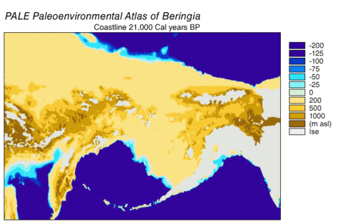
Beringia is defined today as the land and maritime area bounded on the west by the Lena River in Russia; on the east by the Mackenzie River in Canada; on the north by 72 degrees north latitude in the Chukchi Sea; and on the south by the tip of the Kamchatka Peninsula. It includes the Chukchi Sea, the Bering Sea, the Bering Strait, the Chukchi and Kamchatka Peninsulas in Russia as well as Alaska in the United States and the Yukon in Canada.
Landforms are categorized by characteristic physical attributes such as their creating process, shape, elevation, slope, orientation, rock exposure, and soil type.
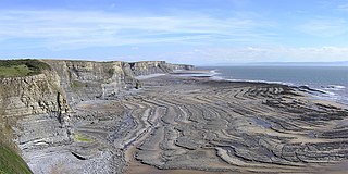
A wave-cut platform, shore platform, coastal bench, or wave-cut cliff is the narrow flat area often found at the base of a sea cliff or along the shoreline of a lake, bay, or sea that was created by erosion. Wave-cut platforms are often most obvious at low tide when they become visible as huge areas of flat rock. Sometimes the landward side of the platform is covered by sand, forming the beach, and then the platform can only be identified at low tides or when storms move the sand.

A continental shelf is a portion of a continent that is submerged under an area of relatively shallow water, known as a shelf sea. Much of these shelves were exposed by drops in sea level during glacial periods. The shelf surrounding an island is known as an insular shelf.
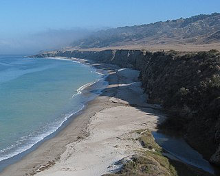
A raised beach, coastal terrace, or perched coastline is a relatively flat, horizontal or gently inclined surface of marine origin, mostly an old abrasion platform which has been lifted out of the sphere of wave activity. Thus, it lies above or under the current sea level, depending on the time of its formation. It is bounded by a steeper ascending slope on the landward side and a steeper descending slope on the seaward side. Due to its generally flat shape, it is often used for anthropogenic structures such as settlements and infrastructure.

The littoral zone, also called litoral or nearshore, is the part of a sea, lake, or river that is close to the shore. In coastal ecology, the littoral zone includes the intertidal zone extending from the high water mark, to coastal areas that are permanently submerged — known as the foreshore — and the terms are often used interchangeably. However, the geographical meaning of littoral zone extends well beyond the intertidal zone to include all neritic waters within the bounds of continental shelves.

Post-glacial rebound is the rise of land masses after the removal of the huge weight of ice sheets during the last glacial period, which had caused isostatic depression. Post-glacial rebound and isostatic depression are phases of glacial isostasy, the deformation of the Earth's crust in response to changes in ice mass distribution. The direct raising effects of post-glacial rebound are readily apparent in parts of Northern Eurasia, Northern America, Patagonia, and Antarctica. However, through the processes of ocean siphoning and continental levering, the effects of post-glacial rebound on sea level are felt globally far from the locations of current and former ice sheets.
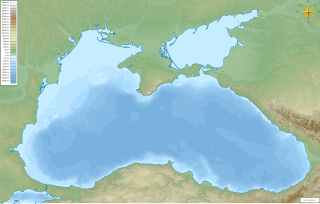
The Black Sea deluge is the best known of three hypothetical flood scenarios proposed for the Late Quaternary history of the Black Sea. One other flood scenario proposes a rapid, even catastrophic, rise in sea level of the Black Sea.

The three Storegga Slides are amongst the largest known submarine landslides. They occurred at the edge of Norway's continental shelf in the Norwegian Sea, approximately 6225–6170 BCE. The collapse involved an estimated 290 km (180 mi) length of coastal shelf, with a total volume of 3,500 km3 (840 cu mi) of debris, which caused a paleotsunami in the North Atlantic Ocean.
Fast ice is sea ice that is "fastened" to the coastline, to the sea floor along shoals, or to grounded icebergs. Fast ice may either grow in place from the sea water or by freezing pieces of drifting ice to the shore or other anchor sites. Unlike drift ice, fast ice does not move with currents and winds.

A marine transgression is a geologic event during which sea level rises relative to the land and the shoreline moves toward higher ground, which results in flooding. Transgressions can be caused by the land sinking or by the ocean basins filling with water or decreasing in capacity. Transgressions and regressions may be caused by tectonic events such as orogenies, severe climate change such as ice ages or isostatic adjustments following removal of ice or sediment load.

An ice shove is a surge of ice from an ocean or large lake onto the shore. Ice shoves are caused by ocean currents, strong winds, or temperature differences pushing ice onto the shore, creating piles up to 12 metres high. Ice shoves can be caused by temperature fluctuations, wind action, or changing water levels and can cause devastation to coastal Arctic communities. Cyclical climate change will also play a role in the formation and frequency of ice shove events; a rise in global temperatures leads to more open water to facilitate ice movement. Low pressure systems will destabilize ice sheets and send them shoreward. Also referred to as "landfast ice", it is an essential component to the coastal sea ice system, including the sediment dynamics. Arctic peoples utilize these ice shoves to travel and hunt. Ringed seals, an important prey for polar bears, are specifically adapted to maintain breathing holes in ice shoves, which lack the same openings usually used by marine mammals in drifting ice packs. The mere fact that the Ringed seal is uniquely adapted to utilizing ice shoves for breathing holes, and that polar bears have adapted to this behaviour for hunting, as well as the fact that the Iñupiat have a distinct term for the phenomena, indicates that ice shoves are a regular and continuing phenomena in the Arctic.

The following outline is provided as an overview of and introduction to Oceanography.
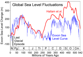
Global or eustatic sea level has fluctuated significantly over Earth's history. The main factors affecting sea level are the amount and volume of available water and the shape and volume of the ocean basins. The primary influences on water volume are the temperature of the seawater, which affects density, and the amounts of water retained in other reservoirs like rivers, aquifers, lakes, glaciers, polar ice caps and sea ice. Over geological timescales, changes in the shape of the oceanic basins and in land/sea distribution affect sea level. In addition to eustatic changes, local changes in sea level are caused by tectonic uplift and subsidence.

Lake Washburn is a lake that formerly existed in the Taylor Valley, McMurdo Dry Valleys, Antarctica. It formed when climatic changes and an expansion of ice caused the flooding of the valley, between 23,000 and 8,340 radiocarbon years ago. Its extent and elevation are unclear but Lake Bonney and Lake Fryxell are considered to be its present-day remnant.