Related Research Articles

Christopher Houston Carson was an American frontiersman. He was a fur trapper, wilderness guide, Indian agent and U.S. Army officer. He became a frontier legend in his own lifetime through biographies and news articles; exaggerated versions of his exploits were the subject of dime novels. His understated nature belied confirmed reports of his fearlessness, combat skills, tenacity, as well as profound effect on the westward expansion of the United States. Although he was famous for much of his life, historians in later years have written that Kit Carson did not like, want, or even fully understand the fame that he experienced during his life.

Questa is a village in Taos County, New Mexico, United States. The population was 1,770 at the 2010 census. The village has trails into the Rio Grande Gorge, trout fishing, and mountain lakes with trails that access the Sangre de Cristo Mountains that overlook the area. Questa is on the Enchanted Circle Scenic Byway, near the confluence of the Rio Grande and the Red River. The "Gateway to the Rio Grande del Norte Monument", its visitors can drive to an overlook of the Red River meeting the Rio Grande in the depth of the gorge. The Carson National Forest parallels Questa to the east. The Columbine Hondo Wilderness and Latir Peak Wildness are in the Carson National Forest close to Questa.
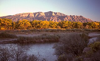
The Sandia Mountains are a mountain range located in Bernalillo and Sandoval counties, immediately to the east of the city of Albuquerque in New Mexico in the southwestern United States. The mountains are just due south of the southern terminus of the Rocky Mountains, and are part of the Sandia–Manzano Mountains. This is largely within the Cibola National Forest and protected as the Sandia Mountain Wilderness. The highest point is Sandia Crest, 10,678 feet (3,255 m).

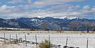
The Sangre de Cristo Mountains are the southernmost subrange of the Rocky Mountains. They are located in southern Colorado and northern New Mexico in the United States. The mountains run from Poncha Pass in South-Central Colorado, trending southeast and south, ending at Glorieta Pass, southeast of Santa Fe, New Mexico. The mountains contain a number of fourteen thousand foot peaks in the Colorado portion, as well as several peaks in New Mexico which are over thirteen thousand feet.

Wheeler Peak is the highest natural point in the U.S. state of New Mexico. It is located northeast of Taos and south of Red River in the northern part of the state, and just 2 miles (3.2 km) southeast of the ski slopes of Taos Ski Valley. It lies in the Sangre de Cristo Mountains, the southernmost subrange of the Rocky Mountains. The peak's elevation is 13,167 feet (4,013 m).

Jicarilla Apache, one of several loosely organized autonomous bands of the Eastern Apache, refers to the members of the Jicarilla Apache Nation currently living in New Mexico and speaking a Southern Athabaskan language. The term jicarilla comes from Mexican Spanish meaning "little basket", referring to the small sealed baskets they used as drinking vessels. To neighboring Apache bands, such as the Mescalero and Lipan, they were known as Kinya-Inde.

Carson National Forest is a national forest in northern New Mexico, United States. It encompasses 6,070 square kilometers and is administered by the United States Forest Service. The Forest Service's "mixed use" policy allows for its use for recreation, grazing, and resource extraction.
Aldo Leopold Wilderness, along with Gila Wilderness and Blue Range Wilderness, is part of New Mexico's Gila National Forest. It became part of the National Wilderness Preservation System in 1980 by an act of the United States Congress and has a total of 202,016 acres (81,753 ha). The wilderness area lies along the crest of the Black Range.

The Cimarron River, flowing entirely in New Mexico, United States, was also known as La Flecha or Semarone. Its headwaters are Moreno, Sixmile, and Cieneguilla creeks in the Sangre de Cristo Mountains, which feed into Eagle Nest Dam. From the dam, it runs for 60 miles (97 km) to below the city of Springer, New Mexico, in the Taylor Springs area, where it flows into the Canadian River, the southwesternmost major tributary flowing into the Mississippi River via the Arkansas River sub-basin.
The Battle of Cieneguilla was an engagement of the Jicarilla War involving a group of Jicarilla Apaches, possibly their Ute allies, and the American 1st Cavalry Regiment on March 30, 1854 near what is now Pilar, New Mexico. The Santa Fe Weekly Gazette reported that the action "was one of the severest battles that ever took place between American troops and Red Indians." It was one of the first significant battles between American and Apache forces and was also part of the Ute Wars, in which Ute warriors attempted to resist Westward expansion in the Four Corners region.
Venado Peak is one of the major peaks of the Taos Mountains group of the Sangre de Cristo Mountains, a subrange of the Rocky Mountains. It is located in Taos County, New Mexico, about 8 miles (13 km) northeast of the town of Questa. Its summit is the highest point in the Latir Peak Wilderness, part of Carson National Forest. The peak's name means "deer" in Spanish.
La Cueva is an unincorporated community on the Mora River in Mora County, New Mexico, United States, situated at the intersection of New Mexico State Roads 442 and 518.

Rayado was the first permanent settlement in Colfax County, New Mexico, United States and an important stop on the Santa Fe Trail. The name Rayado derives from the Spanish term for "streaked", perhaps in reference to the lot lines marked out by Lucien Maxwell.
The 56-mile (90 km) High Road to Taos is a scenic, winding road through the Sangre de Cristo Mountains between Santa Fe and Taos.. It winds through high desert, mountains, forests, small farms, and tiny Spanish land grant villages and Pueblo Indian villages. Scattered along the way are the galleries and studios of traditional artisans and artists drawn by the natural beauty. It has been recognized by the state of New Mexico as an official scenic byway.
El Rito,, is an unincorporated community in Rio Arriba County, New Mexico, United States. Its elevation is 6,875 feet (2,096 m).

Pot Creek Cultural Site is an abandoned 13th century pueblo located on private land owned by Southern Methodist University and on public Carson National Forest land in Taos County, New Mexico.

Talpa is a settlement in Taos County, New Mexico, located 6 miles south of the town of Taos along New Mexico Highway 518.

The Enchanted Circle Scenic Byway is a New Mexico Scenic Byway and National Forest Scenic Byway located in Northern New Mexico. It begins and ends in Taos, New Mexico.

John Dunn Bridge is located in Arroyo Hondo in north-central New Mexico. It crosses the Rio Grande near the confluence of the Rio Hondo. It was built in 1908 by John Dunn who transported travelers and mail into Taos and housed travelers overnight at his hotel near the bridge. It was sold to the Territory of New Mexico in 1912, and at that time the toll bridge was made a free bridge to travelers. Recreational opportunities on the rivers include fishing, kayaking, and whitewater rafting. It is near the Black Rock Hot Springs.
Bobcat Pass is a mountain pass located in Taos County, New Mexico on the Enchanted Circle Scenic Byway.
References
- 1 2 3 Palo Flechado Pass. Archived 2014-10-09 at the Wayback Machine New Mexico Historic Markers. New Mexico Tourism Department. Retrieved August 13, 2014.
- 1 2 3 4 5 Robert Hixson Julyan (1 January 1996). The Place Names of New Mexico. UNM Press. pp. 256–257. ISBN 978-0-8263-1689-9.
- ↑ "Palo Flechado Pass". Geographic Names Information System (GNIS), United States Geological Survey. Retrieved June 4, 2017.
- ↑ Palo Flechado Pass. Topozone. Retrieved August 13, 2014.
- ↑ United States. Forest Service. Southwestern Region (1990). Enchanted Circle and Valle Vidal Loop tours: Carson National Forest. U.S. Dept. of Agriculture. p. 12.
- ↑ Topographic Map Gap Features in Taos County, New Mexico. Topozone. Retrieved August 14, 2014.
- 1 2 David Pike (November 2003). Roadside New Mexico: A Guide to Historic Markers. UNM Press. p. 57. ISBN 978-0-8263-3118-2.
- ↑ Bob Julyan (2004). Best Hikes with Children in New Mexico. The Mountaineers Books. pp. 55–58. ISBN 978-0-89886-886-9.