
Central Sulawesi is a province of Indonesia located at the centre of the island of Sulawesi. The administrative capital and largest city is located in Palu. The 2010 census recorded a population of 2,635,009 for the province, and the 2020 Census recorded 2,985,734, of whom 1,534,706 were male and 1,451,028 were female. The official estimate as at mid 2022 was 3,066,143. Central Sulawesi has an area of 61,605.72 km2 (23,786 sq mi), the largest area among all provinces on Sulawesi Island, and has the second-largest population on Sulawesi Island after the province of South Sulawesi. It is bordered by the provinces of Gorontalo to the north, West Sulawesi, South Sulawesi and South East Sulawesi to the south, by Maluku to the east, and by the Makassar Strait to the west. The province is inhabited by many ethnic groups, such as the Kaili, Tolitoli, etc. The official language of the province is Indonesian, which is used for official purposes and inter-ethnic communication, while there are several indigenous language spoken by the Indigenous peoples of Central Sulawesi. Islam is the dominant religion in the province, followed by Christianity which is mostly adhered to by the people in the eastern part of the province.

Poso is the administrative capital of Poso Regency, Indonesia. It is the main port and transportation hub for the central-southern coast of Central Sulawesi. Its urban area consists of three districts, Poso Kota, North Poso Kota, and South Poso Kota. Poso lies in the middle of the province on the shore of the Gulf of Tomini, right in the central part of Sulawesi island. With a total population of 47,477 in 2020, it is one of the biggest and the oldest towns in the province.

Makassar Strait is a strait between the islands of Borneo and Sulawesi in Indonesia. To the north it joins the Celebes Sea, while to the south it meets the Java Sea. To the northeast, it forms the Sangkulirang Bay south of the Mangkalihat Peninsula. The strait is an important regional shipping route in Southeast Asia.

Palu, which is officially known as the City of Palu, is the capital and largest city of Central Sulawesi. Palu is located on the northwestern coast of Sulawesi and borders Donggala Regency to the north and west, Parigi Moutong Regency to the east, and Sigi Regency to the south. The city boundaries encompass a land area of 395.06 km2 (152.53 sq mi). According to the 2020 Indonesian census, Palu has a population of 373,218, making it the third-most populous city on the island after Makassar and Manado; the official estimate as at mid 2021 was 377,030. Palu is the center of finance, government, and education in Central Sulawesi, as well as one of several major cities on the island. The city hosts the province's main port, its biggest airport, and most of its public universities.

Donggala Regency is a regency in the Central Sulawesi Province of Indonesia. It lies between 0° 30" north and 2°20" south latitude, and between 119° 45°" and 121° 45" east longitude, and covers a land area of 5,275.69 km2. It had a population of 277,236 at the 2010 Census and 300,436 at the 2020 Census; the official estimate as at mid 2022 was 305,890. The administrative capital of Donggala Regency is the town of Banawa, located a 30-minute drive (34 km) northwest from the city of Palu, the capital of the province.

Mutiara SIS Al-Jufrie Airport, formerly Masovu Airport, is an airport near Palu, the capital city of the province of Central Sulawesi on the island of Sulawesi in Indonesia. As the largest airport in Central Sulawesi, Mutiara SIS Al-Jufrie Airport serves as the main port of entry to the city of Palu as well as the surrounding area. The name airport can be separated into two part, "Mutiara" and "SIS Al-Jufrie". "Mutiara" means pearl in Indonesian, while "SIS Al-Jufrie" is an abbreviation of Sayyid Idrus bin Salim Al-Jufri (1892–1969), an Arab-Indonesian religious figure and an Indonesian National Hero from Central Sulawesi. He was a propagator of Islam in Central Sulawesi until his death in Palu in 1969. SIS Aljufri is also a religious figure and founder of the religious organization Alkhairaat that grew and developed rapidly in eastern Indonesia.
The 1968 Sulawesi earthquake struck Indonesia on August 14. It had a Richter magnitude of 7.4, spawned a large tsunami, and killed roughly 200 people.
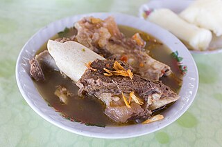
Kaledo is a traditional cow's trotters soup served in spicy broth, from Donggala regency, Central Sulawesi, Indonesia. Per its name, the meat used in this particular food is cow's feet and its marrow. The dish originated from Donggala, and from there spread around Sulawesi.

On 28 September 2018, a shallow, large earthquake struck in the neck of the Minahasa Peninsula, Indonesia, with its epicentre located in the mountainous Donggala Regency, Central Sulawesi. The magnitude 7.5 quake was located 70 km (43 mi) away from the provincial capital Palu and was felt as far away as Samarinda on East Kalimantan and also in Tawau, Malaysia. This event was preceded by a sequence of foreshocks, the largest of which was a magnitude 6.1 tremor that occurred earlier that day.
The Palu-Koro Fault or Palu-Koro Fault System is a major active NNW-SSE trending left-lateral strike-slip fault zone on the island of Sulawesi in Indonesia. It caused the 2018 Sulawesi earthquake and tsunami.
Operation Samudra Maitri is the relief effort launched by India to assist the victims of the 2018 Sulawesi earthquake and tsunami in Indonesia. The operation was launched after communication between the Prime Minister of India Narendra Modi and President of Indonesia Joko Widodo on 1 October 2018.
On January 1, 1996, at 4:05 p.m. Central Indonesia Time, an earthquake with an epicenter in the Makassar Strait struck north of Minahasa on the island of Sulawesi, Indonesia. The earthquake measured 7.9 on the moment magnitude scale and was centered off Tolitoli Regency in Central Sulawesi, or 25 km from the Tonggolobibi village. A tsunami of 2–4 m (6.6–13.1 ft) was triggered by this earthquake as a result. At least 350 buildings were badly damaged, nine people died and 63 people were injured.
A moment magnitude 6.2 earthquake struck Majene Regency in West Sulawesi, Indonesia, on 15 January 2021, at 02:28 WITA. The reverse faulting shock initiated at 18.0 km (11.2 mi) depth with an epicenter inland, located 32 km (20 mi) south of Mamuju. It was preceded by a Mw 5.7 foreshock several hours prior. Shaking from the mainshock was assigned a maximum Modified Mercalli intensity of VI (Strong) in Majene and Mamuju. Four of the five regencies in West Sulawesi were affected. More than 6,000 structures were damaged or destroyed; damage was estimated at Rp829.1 billion rupiah. At least 105 people were confirmed dead; more than 3,300 were injured and thousands were displaced.
The western coast of West Sulawesi was struck by a major earthquake on 23 February 1969 at 00:36 UTC. It had a magnitude of 7.0 and a maximum felt intensity of VIII on the Modified Mercalli intensity scale. It triggered a major tsunami that caused significant damage along the coast of the Makassar Strait. At least 64 people were killed, with possibly a further 600 deaths caused by the tsunami.

Rusdy Mastura is an Indonesian politician who is the governor of Central Sulawesi and was the mayor of the province's capital, Palu, between 2005 and 2015.
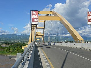
The Palu IV Bridge was an Indonesian suspension bridge that was located in city of Palu in the Indonesian province of Central Sulawesi. It spanned the Palu River, directly at its mouth in Palu Bay, and thus connected the districts of Besuru and Lere.
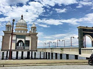
The Floating Mosque of Palu, also known as Arqam Babu Rahman Mosque is a mosque in the city of Palu, Central Sulawesi, Indonesia. The mosque is an icon of Palu, known for floating on Palu Bay.

Petobo is an urban village (kelurahan) in Palu Selatan district, Palu, Central Sulawesi, Indonesia. The village was notable in 2018, when some of its areas was destroyed by a landslide triggered by the Sulawesi earthquake, and was decided to not recovered since then due to its disaster vulnerability.

The Sulawesi Canal, also known as Equatorial Canal, refers to proposals for a canal on the island of Sulawesi, connecting the Gulf of Tomini with the Makassar Strait, with the aim of becoming a busy international sea route that will shorten the sea transport distance from the eastern part of Sulawesi Island to the western part of Indonesia, as well as to the Philippines and Malaysia.
