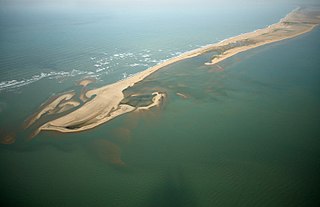
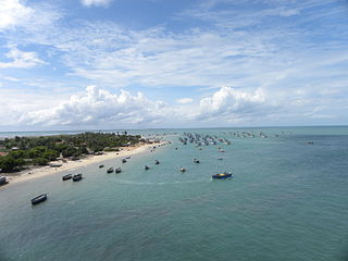
Dhanushkodi is an abandoned town at the south-eastern tip of Pamban Island of the state of Tamil Nadu in India. It is south-east of Pamban and is about 24 kilometres (15 mi) west of Talaimannar in Sri Lanka. The town was destroyed during the 1964 Rameswaram cyclone and remains uninhabited in the aftermath. Although devoid of inhabitants, Dhanushkodi remains a tourist attraction due to its historical and mythological relevance.

Kanyakumari is a city in Kanyakumari district in the state of Tamil Nadu, India. It is the southernmost tip of the Indian subcontinent and the southernmost city in mainland India, and thus referred to as "The Land's End". The city is situated 90 kilometres (56 mi) south of Thiruvananthapuram city, and about 20 kilometres (12 mi) south of Nagercoil, the headquarters of Kanyakumari district.

Rameswaram is a municipality in the Ramanathapuram district of the Indian state of Tamil Nadu. It is on Pamban Island separated from mainland India by the Pamban channel and is about 40 kilometres from Mannar Island, Sri Lanka. It is in the Gulf of Mannar, at the tip of the Indian peninsula. Pamban Island, also known as Rameswaram Island, is connected to mainland India by the Pamban Bridge. Rameswaram is the terminus of the railway line from Chennai and Madurai. Together with Varanasi, it is considered to be one of the holiest places in India to Hindus and is part of the Char Dham pilgrimage.
Ramanathapuram, also known as Ramnad, is a city and a municipality in Ramanathapuram district in the Indian state of Tamil Nadu. It is the administrative headquarters of Ramanathapuram district and the second largest town in Ramanathapuram district. Soon the Ramanathapuram Civic body to be upgraded as Municipal Corporation, after merging with nearby panchayats.

Pamban Bridge is a railway bridge that connects the town of Rameswaram on Pamban Island with Mandapam in mainland India. Opened on 24 February 1914, it was India's first sea bridge, and was the longest sea bridge in India until the opening of the Bandra–Worli Sea Link in 2010. The rail bridge is, for the most part, a conventional bridge resting on concrete piers but has a double-leaf bascule section midway, which can be raised to let ships and barges pass through.
Ramanathapuram District, also known as Ramnad District, is one of the 38 districts an administrative districts of Tamil Nadu state in southern India. The old Ramanathapuram District consists of Present day Virudhunagar and Sivagangai districts, it touches the Western ghats and bordered with the state of Kerala and east by Bay of Bengal. It was the largest district on that time. The town of Ramanathapuram is the district headquarters. Ramanthapuram District has an area of 4,123 km2. It is bounded on the north by Sivaganga District, on the northeast by Pudukkottai District, on the east by the Palk Strait, on the south by the Gulf of Mannar, on the west by Thoothukudi District, and on the northwest by Virudhunagar District. The district contains the Pamban Bridge, an east–west chain of low islands and shallow reefs that extend between India and the island nation of Sri Lanka, and separate the Palk Strait from the Gulf of Mannar. The Palk Strait is navigable only by shallow-draft vessels. As of 2011, Ramanathapuram district had a population of 1,353,445 with a sex-ratio of 983 females for every 1,000 males. The district is home to the pilgrimage center of Rameswaram and tourist spot Dhanushkodi, an abandoned town.
Manamadurai is a Municipality Town in Sivaganga district in the Indian state of Tamil Nadu. Manamadurai falls under Manamadurai Legislative assembly.
Mandapam is a panchayat town in Ramanathapuram district in the Indian state of Tamil Nadu. The famed Pamban Railway bridge and Vehicular bridge lie to the East of this Panchayat Town. Mandapam is Tamil Nadu’s largest refugee camp for Sri Lankans in India.
Thondi is a Panchayat Town located in the Ramanathapuram district of the southern Indian state of Tamil Nadu.
Pamban Island, also known as Rameswaram Island, is an island located between peninsular India and Sri Lanka, on the Adam's Bridge archipelago. The second largest island in the latter, Pamban Island belongs to India and forms the Rameswaram taluk of the Ramanathapuram district of the state of Tamil Nadu. It is the largest island in Tamil Nadu by area. The principal town in the island is the pilgrimage centre of Rameswaram.
Pamban is a town on Pamban Island in the Indian state of Tamil Nadu.
National Highway 49 was a National Highway in southern India under former numbering system.. It traversed coast-to-coast linking Kochi in Kerala with Dhanushkodi in Tamil Nadu. It crosses the famous Pamban Bridge before crossing into Rameswaram island. The total length runs up to 440 km (270 mi). The 5 km road between Mukundarayar Chathiram and Dhanuskodi was destroyed during the 1963 cyclone and was rebuilt.

The Rameswaram Express, previously known as the Boat Mail or Indo-Ceylon Express, is an express train that connects Mandapam with the state capital Chennai via Tambaram, Chengalpet, Melmaruvattur, Viluppuram, Cuddalore port, Chidambaram, Sirkazhi, Mayiladuthurai, Tanjore, Tiruchchirappalli, Pudukkottai, Karaikudi, Sivagangai, Manamadurai and Ramanathapuram. During the 1900s, it was a combined train and steamer ferry service between India and Ceylon. Connecting Chennai and Colombo, the system initially utilised a rail-to-sea operation, but changed to a rail-to-sea-to-rail operation. Passengers could buy a single ticket for the journey. Now, it runs from Chennai Egmore to Rameswaram via Villuppuram, Kumbakonam, Tiruchchirappalli, Pudukkottai, Karaikkudi, Devakottai, Manamadurai, Paramakkudi, Ramanathapuram, Mandapam, and Pamban.
Rameswaram Taluk is a taluk of Ramanathapuram district of the Indian state of Tamil Nadu. The headquarters of the taluk is the town of Rameswaram. The taluk comprises the whole area of Pamban Island.
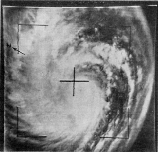
The 1964 Rameswaram cyclone was regarded as one of the most powerful storms to ever strike India on record. The system was first identified as an area of low pressure over the Andaman Sea on December 15. Following interaction with a tropical wave, it began to develop and became a depression by December 18. Increasingly rapid intensification ensued over the following days with the cyclone attaining hurricane-force winds around 5°N the next day. Early on December 23, the storm struck Ceylon near Trincomalee with winds estimated at 240 km/h (150 mph), ranking it as a modern-day super cyclonic storm. Weakening somewhat, the storm soon struck Tamil Nadu. Rapid weakening followed once the cyclone was onshore and it degenerated into a depression on December 24 as it emerged over the Arabian Sea. The system later dissipated on December 26 over open water.
Manamadurai Junction railway station is an NSG–5 category Indian railway station in Madurai railway division of Southern Railway zone. It serves Manamadurai, located in Sivaganga district of the Indian state of Tamil Nadu. It is one of the two major railway junctions within the Sivaganga District; and the other one is Karaikudi Junction which is approximately 60kms north which has four rail branches and a major passenger railhead in the district.

Rameswaram railway station is an NSG–3 category Indian railway station in Madurai railway division of Southern Railway zone. It serves the town of Rameswaram, located in Ramanathapuram district of the Indian state of Tamil Nadu. The station links the pilgrim town as well as the rest of the island to the mainland via the highly acclaimed Pamban Rail Bridge.
National Highway 87 is a National Highway in southern India. It crosses the Pamban Bridge before entering into Pamban Island. The total length runs up to 154 km (96 mi). The 5 km road between Mukundarayar Chathiram and Dhanuskodi was destroyed during the 1964 cyclone. Then the Government of India has started construction of the new stretch of road on 2015 and opened to vehicles with some restrictions on Feb'2017 at a cost of ₹ 250 million. At the same time, the road between Madurai and Rameswaram was converted from a two lane road to a four-lane highway. Then Union minister for road transport and shipping Shri.Nitin Gadkari laid the foundation stone for the Rs 1,387-crore project in Madurai on 17 July 2015. An initial outlay of Rs 927 crore was made {May 2019} and the project has been sanctioned for Rs 1,387 crore. Then the first 75km stretch from Madurai to Paramakudi was proposed to be converted into a proper four-lane road which is a Green Highway, while the remaining 39km stretch from Paramakudi to Ramanathapuram was widened as a two-lane road with paved shoulders. This road includes bypass from Madurai to Manalur which is a newly constructed route skipping the old route(which runs through Puliyankulam and Silaiman), and has bypasses at several places like Thiruppuvanam, Thiruppachethi, Rajagambiram, Paramakudi and Ramanathapuram which would substantially ease traffic congestion in these towns and also saves time for those tourists who are going to Rameswaram. Falling under the Old NH-49, this project is one of the largest completed green corridor in Tamil Nadu by the National Highways Authority of India in the recent times.
The Manamadurai–Rameswaram branch line is a branch railway line in the state of Tamil Nadu, India. The line starts at Manamadurai and ends at Rameswaram.
Pirappan Valasai is a village in Mandapam block in Ramanathapuram District of Tamil Nadu, India.


