Argentina is subdivided into twenty-three federated states called provinces and one called the autonomous city of Buenos Aires, which is the federal capital of the republic as decided by the Argentine Congress. The provinces and the capital have their own constitutions, and exist under a federal system.
Chaco, officially the Province of Chaco, is one of the 23 provinces in Argentina. Its capital and largest city, is Resistencia. It is located in the north-east of the country.

Argentina has a vast territory and a variety of climates and microclimates ranging from tundra and polar in the south to the tropical climate in the north, through a vast expanse of temperate climate. Natural wonders include the Aconcagua, the highest mountain in the world outside the Himalayas, the widest river and estuary of the planet, the Iguazú Falls, the Humid Pampas, and the Argentine Sea. Visitors enjoy the culture, customs and Argentine cuisine.

Tucumán is the most densely populated, and the second-smallest by land area, of the provinces of Argentina.

Jujuy[xuˈxuj] is a province of Argentina, located in the extreme northwest of the country, at the borders with Chile and Bolivia. The only neighboring Argentine province is Salta to the east and south.

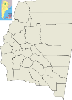
Santiago del Estero, also known simply as Santiago, is a province in the north of Argentina. Neighboring provinces, clockwise from the north, are Salta, Chaco, Santa Fe, Córdoba, Catamarca and Tucumán.

Santiago del Estero is the capital of Santiago del Estero Province in northern Argentina. It has a population of 252,192 inhabitants, making it the twelfth largest city in the country, with a surface area of 2,116 km². It lies on the Dulce River and on National Route 9, at a distance of 1,042 km north-northwest from Buenos Aires. Estimated to be 455 years old, Santiago del Estero was the first city founded by Spanish settlers in the territory that is now Argentina. As such, it is nicknamed "Madre de Ciudades". Similarly, it has been officially declared the "mother of cities and cradle of folklore."
At the national level, Argentina elects a head of state and a legislature. The franchise extends to all citizens aged 16 and over, and voting is mandatory for all those who are between 18 and 70 years of age.
Guasayán Department is a departamento of the province of Santiago del Estero, Argentina.

The Salado River is a river that crosses several provinces of Argentina, flowing 1,150 kilometres (710 mi) from its source in the Salta Province to end in the Paraná River, in the Santa Fe Province. Because its origin, its flow varies widely within the year, and it can dry out in some parts of its path during the winter. The only important tributary to the river is the Horcones River, which is born in Salta as Cajón River, and joins the Salado in the Santiago del Estero Province.

National Route 9 is a major road in Argentina, which runs from the center-east to the northwest of the country, crossing the provinces of Buenos Aires, Santa Fe, Córdoba, Santiago del Estero, Tucumán, Salta and Jujuy. It starts on Avenida General Paz, which marks the border between the Autonomous City of Buenos Aires and the surrounding province of the same name, and ends at the Horacio Guzmán International Bridge, on the La Quiaca River, traversing 1,967 km (1,222 mi). The road is a limited access motorway from Buenos Aires to Rosario.

La Banda is a city in the province of Santiago del Estero, Argentina. It has about 95,000 inhabitants as per the 2001 census [INDEC], making it the second largest in the province. It is the head town of the Banda Department.

The General Manuel Belgrano Railway (FCGMB), named after the Argentine politician and military leader Manuel Belgrano, is a 1,000 mmmetre gauge railway and the longest of the Argentine system. It was one of the six State-owned Argentine railway companies formed after President Juan Perón's nationalisation of the railway network in 1948.
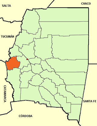
Cruz Alta Department is a department located in the east of the Tucumán Province, Argentina. In 2001 its population was 162,240 largely located in the Banda del Río Salí-Alderetes Area (northwest). The Department seat is the city of Banda del Río Salí.
Árraga is a municipality and village in Santiago del Estero in Argentina. It is the head district of the Silípica Department to the southwest of the province of Santiago del Estero. It is located 32 km from the provincial capital city of Santiago del Estero (capital), south along National Route 9.

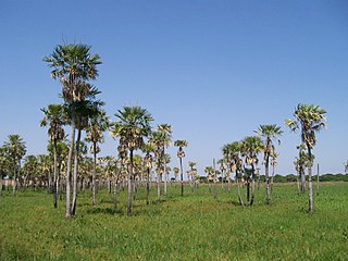
Monte Quemado is a municipality and village in Santiago del Estero in Argentina. It is the capital city of the Copo Department, Province of Santiago del Estero, Argentina, in the Chaco Austral region, practically in the El Impenetrable phytogeographic zone. It lies on national road RN 16, a route that runs parallel to a branch of the General Manuel Belgrano Railway and the aqueduct diverter from the Salado del Norte River known as the Canal de Dios. Precisely in Monte Quemado it starts as a branch of the aqueduct, the branch that goes to the south is called the Virgen del Carmen Canal, which runs parallel to provincial road RP 5 that connects Monte Quemado with Campo Gallo. Another land route which coincides with the RN 16 and RP 5 in Monte Quemado is provincial road RP 4.

Mennonites in Argentina belong to two quite different groups: conservative and very conservative Plautdietsch-speaking group of Russian Mennonites who are descendants of Friesian, Flemish and Prussian people, and converts to the Mennonite faith from the general Argentinian population. The Russian Mennonites are the third largest community of Mennonites in South America, with six colonies in Argentina. While Russian Mennonites have their own language and customs and live in colonies, converts to the Mennonite faith normally live in cities and speak Spanish and do not differ much from other Protestants in Argentina. Conservative ethnic Mennonites normally do not engage in missionary activities but look for a quiet and remote place where they can live according to their tradition. More liberal Mennonites are engaged in worldwide missionary work like other North American Protestant denominations. About one third of Mennonites in Argentina are conservative ethnic Mennonites who belong to the Altkolonier branch.

Mercedes Mariana "Nina" Aragonés de Juárez is an Argentine politician who was Governor of Santiago del Estero Province from 2002 to 2004. The wife of longtime governor and local caudillo Carlos Arturo Juárez, Aragonés was the last head of a provincial state in Argentina removed from office through federal intervention.

Oscar Herrera Ahuad is an Argentine physician and politician who is currently governor of Misiones Province, since 10 December 2019. Prior to that, he served as Vice Governor under his predecessor, Hugo Passalacqua. Herrera Ahuad belongs to the Party of Social Concord.

This article presents official statistics gathered during the COVID-19 pandemic in Argentina. The National Ministry of Health publishes official numbers every night.