Related Research Articles
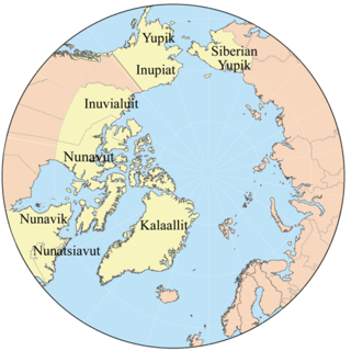
Eskimo or Eskimos is a collective term used to refer to the Inuit and the Yupik of eastern Siberia and Alaska. A third group, the Aleut, which inhabit the Aleutian Islands, are closely related to both, but are generally excluded from the definition of Eskimo. The three groups share a relatively recent common ancestor, and speak related languages belonging to the Eskimo–Aleut language family.

Greenland is the world's largest island, located between the Arctic and Atlantic oceans, east of the Canadian Arctic Archipelago. Greenland is an autonomous territory within the Kingdom of Denmark. Though physiographically a part of the continent of North America, Greenland has been politically and culturally associated with Europe for more than a millennium, beginning in 986. The majority of its residents are Inuit, whose ancestors migrated from Alaska through Northern Canada, gradually settling across the island by the 13th century.

The Northwest Passage (NWP) is the sea route between the Atlantic and Pacific oceans through the Arctic Ocean, along the northern coast of North America via waterways through the Canadian Arctic Archipelago. The eastern route along the Arctic coasts of Norway and Siberia is accordingly called the Northeast Passage (NEP). The various islands of the archipelago are separated from one another and from Mainland Canada by a series of Arctic waterways collectively known as the Northwest Passages or Northwestern Passages.
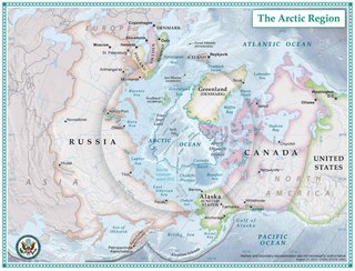
The Arctic is a polar region located at the northernmost part of Earth. The Arctic consists of the Arctic Ocean, adjacent seas, and parts of Alaska, Canada, Finland, Greenland (Denmark), Iceland, Norway, Russia, and Sweden. Land within the Arctic region has seasonally varying snow and ice cover, with predominantly treeless permafrost containing tundra. Arctic seas contain seasonal sea ice in many places.

Ellesmere Island is Canada's northernmost and third largest island, and the tenth largest in the world. It comprises an area of 196,235 km2 (75,767 sq mi), slightly smaller than Great Britain, and the total length of the island is 830 km (520 mi).

Baffin Island, in the Canadian territory of Nunavut, is the largest island in Canada and the fifth-largest island in the world. Its area is 507,451 km2 (195,928 sq mi) and its population was 13,148 as of the 2016 Canadian Census. It is located in the region of 68°N70°W

The Iñupiat are a group of Alaska Natives, whose traditional territory roughly spans northeast from Norton Sound on the Bering Sea to the northernmost part of the Canada–United States border and often claim to be the first people of the Kauwerak. Their current communities include 34 villages across Iñupiat Nunaŋat including seven Alaskan villages in the North Slope Borough, affiliated with the Arctic Slope Regional Corporation; eleven villages in Northwest Arctic Borough; and sixteen villages affiliated with the Bering Straits Regional Corporation.

Grise Fiord is an Inuit hamlet on the southern tip of Ellesmere Island, in the Qikiqtaaluk Region in the territory of Nunavut, Canada. It is one of three settlements on the island; despite its low population, it is the largest community on Ellesmere Island. The settlement at Grise Fiord, created by the Canadian Government in 1953 through a relocation of Inuit families from Inukjuak, Quebec, is the northernmost public community in Canada. It is also one of the coldest inhabited places in the world, with an average yearly temperature of −16.5 °C (2.3 °F).

Igloolik is an Inuit hamlet in Foxe Basin, Qikiqtaaluk Region in Nunavut, northern Canada. Because its location on Igloolik Island is close to Melville Peninsula, it is often mistakenly thought to be on the peninsula. The name "Igloolik" means "there is a house here". It derives from iglu, meaning house or building, and refers to the sod houses that were originally in the area, not to snow igloos. In Inuktitut the residents are called Iglulingmiut.

Pond Inlet is a small, predominantly Inuit community in the Qikiqtaaluk Region of Nunavut, Canada, located on northern Baffin Island. To the Inuit the name of the place "is and always has been Mittimatalik." The Scottish explorer Sir John Ross had named an arm of the sea that separates Bylot Island from Baffin Island as Pond's Bay, and the hamlet now shares that name. On August 29, 1921, the Hudson's Bay Company opened its trading post near the Inuit camp and named it Pond Inlet, marking the expansion of its trading empire into the High Arctic.

Cambridge Bay is a hamlet located on Victoria Island in the Kitikmeot Region of Nunavut, Canada. It is the largest settlement on Victoria Island. Cambridge Bay is named for Prince Adolphus, Duke of Cambridge (1774-1850), while the traditional Inuinnaqtun name for the area is Ikaluktutiak or Iqaluktuttiaq meaning "good fishing place".

Resolute or Resolute Bay is an Inuit hamlet on Cornwallis Island in Nunavut, Canada. It is situated at the northern end of Resolute Bay and the Northwest Passage and is part of the Qikiqtaaluk Region.

The Scott Polar Research Institute (SPRI) is a centre for research into the polar regions and glaciology worldwide. It is a sub-department of the Department of Geography in the University of Cambridge, located on Lensfield Road in the south of Cambridge.

HMS Terror was a specialised warship and a newly developed bomb vessel constructed for the Royal Navy in 1813. She participated in several battles of the War of 1812, including the Battle of Baltimore with the bombardment of Fort McHenry. She was converted into a polar exploration ship two decades later, and participated in George Back's Arctic expedition of 1836–1837, the successful Ross expedition to the Antarctic of 1839 to 1843, and Sir John Franklin's ill-fated attempt to force the Northwest Passage in 1845, during which she was lost with all hands along with HMS Erebus.

Nunavut is the largest and northernmost territory of Canada. It was separated officially from the Northwest Territories on April 1, 1999, via the Nunavut Act and the Nunavut Land Claims Agreement Act, which provided this territory to the Inuit for independent government. The boundaries had been drawn in 1993. The creation of Nunavut resulted in the first major change to Canada's political map since the province of Newfoundland was incorporated in 1949.

Climate change in the Arctic is causing major environmental issues. These range from the well known, such as the loss of sea ice or melting of the Greenland ice sheet, to more obscure, but deeply significant issues, such as permafrost thaw, social consequences for locals and the geopolitical ramifications of these changes.

The Inuit are a group of culturally similar indigenous peoples inhabiting the Arctic regions of Greenland, Canada, and Alaska. The Inuit languages are part of the Eskimo–Aleut languages also known as Inuit-Yupik-Unangan and also as Eskaleut. Inuit Sign Language is a critically endangered language isolate used in Nunavut.

Franklin's lost expedition was a British voyage of Arctic exploration led by Captain Sir John Franklin that departed from England in 1845 aboard two ships, HMS Erebus and HMS Terror, and was assigned to traverse the last unnavigated sections of the Northwest Passage in the Canadian Arctic and to record magnetic data to help determine whether a better understanding could aid navigation. The expedition met with disaster after both ships and their crews, a total of 129 officers and men, became icebound in Victoria Strait near King William Island, in what is today the Canadian territory of Nunavut. After being icebound for more than a year, Erebus and Terror were abandoned in April 1848, by which point Franklin and nearly two dozen others had died. The survivors, now led by Franklin's second-in-command, Francis Crozier and Erebus' captain James Fitzjames, set out for the Canadian mainland and disappeared.

The Arctic Ocean is the smallest and shallowest of the world's five major oceans. It spans an area of approximately 14,060,000 km2 (5,430,000 sq mi) and is also known as the coldest of all the oceans. The International Hydrographic Organization (IHO) recognizes it as an ocean, although some oceanographers call it the Arctic Mediterranean Sea. It has been described approximately as an estuary of the Atlantic Ocean. It is also seen as the northernmost part of the all-encompassing World Ocean.

The Arctic sea ice decline has occurred in recent decades by sea ice in the Arctic Ocean melting faster than it refreezes in the winter. The IPCC's Fourth Assessment Report (2007) stated that greenhouse gas forcing is predominantly responsible for the decline in Arctic sea ice extent.
References
- Griggs, Mary Beth (11 June 2014). "The snowy, barren arctic actually contains a sophisticated network of Inuit trails". Smithsonian Institution. Retrieved 7 October 2018.
- Doyle, Sabrina (23 June 2014). "New Inuit trail map could change the way we look at the North". Canadian Geographic . Retrieved 7 October 2018.
- Rogers, Sarah (13 June 2014). "New online atlas tracks Nunavut's centuries-old Inuit trails". Nunatsiaq News. Retrieved 23 March 2019.
- Russon, Mary-Ann (11 June 2014). "First ever interactive atlas of ancient Inuit arctic trails goes live". International Business Times . Retrieved 7 October 2018.
- "New atlas documents traditional Inuit trail network". CBC News. Canadian Press. 12 June 2014. Retrieved 7 October 2018.
- "Pan Inuit Trails Atlas featured in documentary". Dal News, Dalhousie University. December 2014. Retrieved 23 March 2014.
- "Pan Inuit Trails". MacOdrum Library. 11 June 2014. Retrieved 7 October 2018.
- "What is unique about this Atlas". Pan Inuit Trails Atlas. Retrieved 24 March 2019.