Panchgram

Last updated

H.P.C Township Panchgram
H.P. C/Cachar Paper Mill Township, Panchgram
Industrial Township
India Assam location map.svg
Red pog.svg
H.P.C Township Panchgram
Location in Assam, India
India location map.svg
Red pog.svg
H.P.C Township Panchgram
H.P.C Township Panchgram (India)
Coordinates: 24°51′40″N92°35′46″E / 24.86111°N 92.59611°E / 24.86111; 92.59611
CountryFlag of India.svg  India
State Assam
District Cachar
Founded by Government of India
Named for Cachar Paper Mill, A unit of Hindustan Paper Corporation Limited
Government
  Body Ministry of Heavy Industries and Public Enterprises
Population
 (2001)
  Total5,578
Languages
  Official Bengali and Meitei (Manipuri)
Time zone UTC+5:30 (IST)
Vehicle registration AS 11

Hindustan Paper Corporation Limited Township, Panchgram is an industrial township in Panchgram under Cachar district, state of Assam. It is the finest township of the Barak Valley Under Hindustan Paper Corporation Limited (It is also called the second Shillong of Barak Valley Area).

Contents

Demographics

Bengali and Meitei (Manipuri) are the official languages of this place. [1] [2]

As of 2001 India census, [3] Hindustan Paper Corporation Ltd. Township Area Panchgram had a population of 5578. Males constitute 54% of the population and females 46%. Hindustan Paper Corporation Ltd. Township Area Panchgram has an average literacy rate of 73%, higher than the national average of 59.5%: male literacy is 79%, and female literacy is 67%. In Hindustan Paper Corporation Ltd. Township Area Panchgram, 14% of the population is under 6 years of age.

Politics

Panchgram is a part of Algapur(Lok Sabha constituency)

Transportation

The national highway NH 6 (Old NH 53) passes through the township and connects this place to Guwahati via Shillong.

Geography

The Township area of Hindustan Paper Corporation Ltd is a hilly region with an average height of 100 m. The hills are fold mountains with rocks.
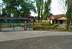
Education/School

Front gate of Kendriya Vidyalaya Panchgrm 1939581463big 25 230.jpg
Front gate of Kendriya Vidyalaya Panchgrm

Clubs

  1. Cachar Paper Mill Employees Recreation and Welfare Club
  2. New Township Club
  3. Officers Club
  4. Cachar Paper Mill Ladies Club
  5. Children's Development Center

Unions/Associations

  1. Cachar Paper Mill Mazdoor Sangh (BHARTIYA MAZDOOR SANGH)
  2. Cachar Paper Workers and Employees Union (Recognized)
  3. Cachar Paper Mill Workers Union
  4. Cachar Paper Mill Mazdoor Union
  5. Cachar Paper Mill Officers and Supervisors Association
  6. Cachar Paper Mill SC/ST Welfare Association

Holy Spots

  1. Ram Mandir, Micro Area
  2. Kali Mandir, Central Area of Township
  3. Shani Mandir, Old Township Area
  4. Cachar Paper Mill Christian Church, Old Township Area

Related Research Articles

<span class="mw-page-title-main">Cachar district</span> District of Assam in India

Cachardistrict is an administrative district in the state of Assam in India. After independence, the pre-existing undivided Cachar district was split into four districts: Dima Hasao, Hailakandi, Karimganj, and the current Cachar district. Silchar is Cachar district's center of government.

<span class="mw-page-title-main">Hailakandi district</span> District of Assam in India

Hailakandi district is one of the 33 districts of Assam state in north-eastern India. It makes up the Barak Valley alongside Cachar and Karimganj. It was constituted as a civil subdivision on 1 June 1869. Subsequently, it was upgraded to a district in 1989, when it was split from Cachar district.

<span class="mw-page-title-main">Karimganj district</span> District of Assam in India

Karimganj district is one of the 31 districts of the Indian state of Assam. Karimganj town is both the administrative headquarters district and the biggest town of this district. It is located in southern Assam and borders Tripura and the Sylhet Division of Bangladesh. It makes up the Barak Valley alongside Hailakandi and Cachar. Karimganj was previously part of the Sylhet District before the Partition of India. It became a district in 1983.

<span class="mw-page-title-main">Silchar</span> City in Assam, India

Silchar is a city and the headquarters of the Cachar district of the state of Assam, India. It is second largest city of Assam after Guwahati in terms of area, population and GDP. It is also administrative capital of Barak Valley division. It is located 343 kilometres south east of Guwahati. It was founded by Captain Thomas Fisher in 1832 when he shifted the headquarters of Cachar to Janiganj in Silchar. It earned the moniker "Island of Peace" from Indira Gandhi, the then Prime Minister of India. Silchar is the site of the world's first polo club and the first competitive polo match. In 1985, an Air India flight from Kolkata to Silchar became the world's first all-women crew flight. Silchar was a tea town and Cachar club was the meeting point for tea planters.

<span class="mw-page-title-main">Namrup</span> Town in Assam, India

Namrup is a small town situated close to the foothills of the Patkai Hills in the extreme southeastern part of Assam, India. The river Dihing or Disang flows through it. Namrup is situated in amidst wet-paddy fields, indigenous Assamese villages, orchards, large tea-gardens and densely forested hills. Administratively Namrup is located within Dibrugarh district and is today an important industrial town of Assam. Namrup is approximately 75 km from Dibrugarh by road towards the south-east and approximately 50 km from Tinsukia towards the south. It is also a small railway station in Dibrugarh-Guwahati broad-gauge railway line. The nearest airport is Dibrugarh located at a distance of approximately 70 km. Other urban areas close to Namrup are Naharkatiya - 18 km, Duliajan - 35 km, Sonari - 20 km, Moran - 55 km, etc. by roadways. Namrup is located around 500 km east of Guwahati, the largest city in the North East Region.

<span class="mw-page-title-main">Karimganj</span> City in Assam, India

Karimganj is a city in the Karimganj District of the Indian state of Assam. It is the administrative headquarters of the district.

Ambikapur Part-X is a census town in Cachar district in the state of Assam, India.

Badarpur Railway Town is a census town in Cachar district in the state of Assam, India. Together with adjacent Badarpur Town, it forms the Badarpur Urban Area, one of two notified urban areas in the district.

Durga Nagar Part-V is a census town in Cachar district in the state of Assam, India.

Jagiroad is a town in the state of Assam. Jagiroad located in Mayong Sub-Division, in Morigaon district. It is situated on the south bank of Kolong river.

Kanakpur Part-II is a census town in Cachar district in the Indian state of Assam.

Silchar Part-X is a census town in Cachar district in the Indian state of Assam.

Uttar Krishnapur Part-I is a census town in Cachar district in the Indian state of Assam.

<span class="mw-page-title-main">Barak Valley</span> Region in the Indian state of Assam

The Barak Valley is the southernmost region and administrative division of the Indian state of Assam. It is named after the Barak river. The Barak valley consists of three administrative districts of Assam namely - Cachar, Karimganj, and Hailakandi. The main and largest city is Silchar, which seats the headquarter of Cachar district and also serves as administrative divisional office of Barak valley division. The valley is bordered by Mizoram and Tripura to the south, Bangladesh and Meghalaya to the west and Manipur to the east respectively. Once North Cachar Hills was a part of Cachar district which became a subdivision in 1951 and eventually a separate district. On 1 July 1983, Karimganj district was curved out from the eponymous subdivision of Cachar district. In 1989 the subdivision of Hailakandi was upgraded into Hailakandi district.

Jirighat is a block headquarters in Cachar district, Assam, India. Jirighat is a tea estate.

<span class="mw-page-title-main">National Highway 6 (India)</span> National highway in India

National Highway 6, commonly referred to as NH 6, is a primary national highway in India. The highway passes through the Indian states of Meghalaya, Assam, and Mizoram. Before renumbering of national highways NH-6 was variously numbered as old national highways 40, 44, 154 & 54.

Udharbond is a Tehsil or Block in Cachar district in the state of Assam, India. It is located 17 km from District headquarters Silchar.

<span class="mw-page-title-main">Sonai</span> Municipality in Assam, India

Sonai is a town in the Cachar district in the Indian state of Assam. It is also the name of a circle and block in the town. Government of Assam declared it as a municipal area on 2016 with 11 wards. The River Sonai flows through the town of Sonai joining with Barak River near Dungripar Village of Sonai. The Chandragiri Park and an Archeological site, a temple of Kachari Kingdom at Shivtilla (Changutilla) near Madhab Chandra Das College is a famous place to visit.

<span class="mw-page-title-main">Jiribam district</span> District of Manipur

Jiribam District is a district in the state of Manipur, India. It was created in December 2016 from the Imphal East district.

<span class="mw-page-title-main">Barak state movement</span> Movement for proposed separate Barak state in India

The Barak state movement includes political activities organised by various individuals, organizations and political parties, for creation of a separate state of Barak, within the republic of India, with Silchar as the capital. The proposed state corresponds to the 5 southern districts of the state of Assam namely: Cachar, Hailakandi, Karimganj, Dima Hasao, Hojai's and Jiribam of Manipur respectively. The total area and population of proposed state is 13,379 km² and 4.5 million as per 2011 Census. The area is covered by thick tropical forests and is surplus in natural resources like tea, oil, natural gas and jute. There are around 125 tea gardens across the Valley. The Minister of Petroleum and Natural Gas of India Mr. Hardeep Singh Puri on a visit have stated that the region is rich in natural gas and have further said that, "If those huge reserve is properly used, then it will definitely boost local industry & employment.

References

  1. "Govt withdraws Assamese as official language from Barak valley". Business Standard India. Press Trust of India. 9 September 2014. Archived from the original on 29 January 2018. Retrieved 29 January 2018.
  2. Purkayastha, Biswa Kalyan (24 February 2024). "Assam recognises Manipuri as associate official language in four districts". Hindustan Times. Retrieved 26 February 2024.
  3. "Census of India 2001: Data from the 2001 Census, including cities, villages and towns (Provisional)". Census Commission of India. Archived from the original on 16 June 2004. Retrieved 1 November 2008.
  4. "Kendriya Vidyalaya HPC/CPM PANCHGRAM :: Home Page". www.kvpanchgram.edu.in. Archived from the original on 16 April 2019. Retrieved 16 April 2019.