This is a demography of the population of El Salvador including population density, ethnicity, education level, health of the populace, economic status, religious affiliations and other aspects of the population.

The Day of the Dead is a holiday traditionally celebrated on November 1 and 2, though other days, such as October 31 or November 6, may be included depending on the locality. The multi-day holiday involves family and friends gathering to pay respects and remember friends and family members who have died. These celebrations can take a humorous tone, as celebrants remember amusing events and anecdotes about the departed. It is widely observed in Mexico, where it largely developed, and is also observed in other places, especially by people of Mexican heritage. The observance falls during the Christian period of Allhallowtide. Some argue that there are Indigenous Mexican or ancient Aztec influences that account for the custom, though others see it as a local expression of the Allhallowtide season that was brought to the region by the Spanish; the Day of the Dead has become a way to remember those forebears of Mexican culture. The Day of the Dead is largely seen as having a festive characteristic.

Mestizo is a person of mixed European and non-European ancestry in the former Spanish Empire. In certain regions such as Latin America, it may also refer to people who are culturally European even though their ancestors were Indigenous American. The term was used as an ethno-racial exonym for mixed-race castas that evolved during the Spanish Empire. It was a formal label for individuals in official documents, such as censuses, parish registers, Inquisition trials, and others. Priests and royal officials might have classified persons as mestizos, but individuals also used the term in self-identification. With the Bourbon reforms and the independence of the Americas, the caste system disappeared and terms like "mestizo" fell in popularity.

The Pipil are an indigenous group of Mesoamerican people inhabiting the western and central areas of present-day El Salvador. They are a subgroup of the larger Nahua ethnic group. They speak the Nawat language, which is a closely related but distinct language from the Nahuatl of Central Mexico. There are very few speakers of Nawat left, but there are efforts being made to revitalize it.

The Nahuas are a Uto-Nahuan ethnicity and one of the indigenous people of Mexico, with Nahua minorities also in El Salvador, Guatemala, Honduras, Nicaragua, and Costa Rica. They comprise the largest indigenous group in Mexico, as well as the largest group of Native Americans in North America by number of native speakers, and the third in the Americas after Guaraní and Quechua.

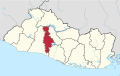
Sonsonate is a department of El Salvador in the western part of the country. The capital is Sonsonate.

The culture of El Salvador is a Central American culture nation influenced by the clash of ancient Mesoamerica and medieval Iberian Peninsula. Salvadoran culture is influenced by Native American culture as well as Latin American culture. Mestizo culture, Afro-Latin culture and the Catholic Church dominates the country. Although the Romance language, Castilian Spanish, is the official and dominant language spoken in El Salvador, Salvadoran Spanish which is part of Central American Spanish has influences of Native American languages of El Salvador such as Lencan languages, Cacaopera language, Mayan languages and Pipil language, which are still spoken in some regions of El Salvador.

Anamorós is a municipality in the La Unión department of El Salvador.
La Libertad ('Liberty') is a municipality in the La Libertad Department of El Salvador. It had a population of 35,997 inhabitants in 2007 according to the official census of that year. It is one of the main tourist attractions in the country.

Juayúa is a city and municipality in the Sonsonate department of El Salvador. It is a small town up in the mountains, founded in 1577. Juayua is located in the western part of El Salvador, about 50 miles from San Salvador.

Nahuizalco is a municipality in the Sonsonate department of El Salvador. It lies on the "flowers route", 9 km from Sonsonate and 74 km from San Salvador, at 540 m above sea level on the southern part of the Apaneca-Ilamatepec mountain range. Per the population and housing census of 2007, Nahuizalco has 49,081 residents.
Agua Caliente is a municipality in the Chalatenango department of El Salvador
Nawat is a Nahuan language native to Central America. It is the southernmost extant member of the Uto-Aztecan family. Before Spanish colonization it was spoken in several parts of present-day Central America, most notably El Salvador and Nicaragua, but now is mostly confined to western El Salvador. It has been on the verge of extinction in El Salvador, and has already gone extinct elsewhere in Central America. In 2012, a large number of new Nawat speakers started to appear. As of today, the language is currently going through a revitalization.
The Lencan languages are a small linguistic family from Central America, whose speakers before the Spanish conquest spread throughout El Salvador and Honduras. But by the beginning of the 20th century, only two languages of the family survived, Salvadoran Lenca or Potón and Honduran Lenca, which were described and studied academically; Of them, only Salvadoran Lenca still has current speakers, despite the fact that indigenous people belonging to the Lenca ethnic group exceed between 37,000 and 100,000 people.
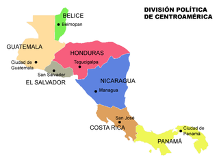
Central America is a subregion of the Americas formed by six Latin American countries and one (officially) Anglo-American country, Belize. As an isthmus it connects South America with the remainder of mainland North America, and comprises the following countries : Belize, Guatemala, Honduras, El Salvador, Nicaragua, Costa Rica, and Panama.
Salvadorans, also known as Salvadorians, are citizens of El Salvador, a country in Central America. Most Salvadorans live in El Salvador, although there is also a significant Salvadoran diaspora, particularly in the United States, with smaller communities in other countries around the world.
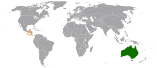
Salvadoran Australians are Australians of Salvadoran descent. Salvadoran immigration to Australia was caused principally by economic and political turmoil in El Salvador.

San Salvador Huixcolotla is a town and municipality in the Mexican state of Puebla in southeastern Mexico that may be best known as the birthplace of papel picado. San Salvador is of Spanish origin and translates to "Holy Savior" and Huixcolotla is Nahuatl for "place of the curved spines".

Afro Salvadorans are Salvadorans of Sub-Saharan African descent. They are the descendants of slaves brought to El Salvador via the Trans-atlantic slave trade during the colonial Spanish era.
Nestor Raul Renderos López is a Salvadoran professional footballer who plays as a midfielder.