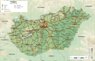
Hungary is a landlocked country in the southeastern region of Central Europe, bordering the Balkans. Situated in the Pannonian Basin, it has a land area of 93,030 square km, measuring about 250 km from north to south and 524 km from east to west. It has 2,106 km of boundaries, shared with Slovakia to the north, Ukraine to the northeast, Romania to the east and southeast, Serbia to the south, Croatia to the southwest, Slovenia to the west and southwest, and Austria to the west.

In geography, a plain, commonly known as flatland, is a flat expanse of land that generally does not change much in elevation, and is primarily treeless. Plains occur as lowlands along valleys or at the base of mountains, as coastal plains, and as plateaus or uplands. Plains are one of the major landforms on earth, being present on all continents and covering more than one-third of the world's land area. Plains in many areas are important for agriculture. There are various types of plains and biomes on them.

In physical geography, a steppe is an ecoregion characterized by grassland plains without closed forests except near rivers and lakes. Steppe biomes may include:

Lake Neusiedl, or Fertő, is the largest endorheic lake in Central Europe, straddling the Austrian–Hungarian border. The lake covers 315 km2 (122 sq mi), of which 240 km2 (93 sq mi) is on the Austrian side and 75 km2 (29 sq mi) on the Hungarian side. The lake's drainage basin has an area of about 1,120 km2 (430 sq mi). From north to south, the lake is about 36 km (22 mi) long, and it is between 6 km and 12 km wide from east to west. On average, the lake's surface is 115.45 m (378.8 ft) above the Adriatic Sea and the lake is no more than 1.8 m deep.

The Pannonian Basin, or Carpathian Basin, is a large sedimentary basin situated in southeast Central Europe. After the WW1 and Treaty of Trianon, the geomorphological term Pannonian Plain became more widely used for roughly the same region though with a somewhat different sense, with only the lowlands, the plain that remained when the Pliocene Epoch Pannonian Sea dried out.

Hortobágy is an 800 km2 national park in eastern Hungary, rich with folklore and cultural history. The park, a part of the Alföld, was designated as a national park in 1973, and elected among the World Heritage Sites in 1999. The Hortobágy is Hungary's largest protected area, and the largest semi-natural grassland in Europe.
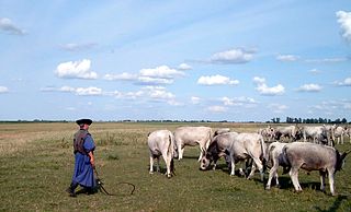
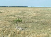
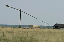
The Hungarian puszta is a temperate grassland biome of the Great Hungarian Plain. It is an exclave of the Pannonian Steppe, and lies mainly around the River Tisza in the eastern part of Hungary, as well as in the western part of the country and in the Burgenland of Austria.
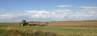
The Great Hungarian Plain is a plain occupying the majority of the modern territory of Hungary. It is the largest part of the wider Pannonian Plain. Its territory significantly shrank due to its eastern and southern boundaries being adjusted by the new political borders created after World War I when the Treaty of Trianon was signed in 1920.

The Little Hungarian Plain or Little Alföld is a plain of approximately 8,000 km² in northwestern Hungary, south-western Slovakia, and eastern Austria. It is a part of the Pannonian plain which covers most parts of Hungary.

Burgenland Croats are ethnic Croats in the Austrian state of Burgenland, along with Croats in neighboring Hungary and Slovakia.

Stipa pennata, commonly known as European feather grass, is a flowering plant and arid zone sand grass in the grass family Poaceae, which is grown as an ornamental plant for its feathery flowering spikes. It is one of the most common plants of the Eurasian Steppe from Mongolia in the east to the Puszta in Hungary and the Devínska Kobyla forest-steppe in Slovakia in the west. Its foliage is green in summer while the flowers are silvery-grey during the same season. It is 60–90 centimetres (24–35 in) high.

The Eurasian Steppe, also called the Great Steppe or The Steppes, is the vast steppe ecoregion of Eurasia in the temperate grasslands, savannas and shrublands biome. It stretches through Hungary, Bulgaria, Romania, Moldova, Ukraine, southern Russia, Kazakhstan, Xinjiang, Mongolia and Manchuria, with one major exclave, the Pannonian steppe, located mostly in Hungary.
Podersdorf am See is a market town in the district of Neusiedl am See in Burgenland in the east of Austria on the shore of the Neusiedler See. It is home to a windmill and lake.

Devínska Kobyla is the highest peak in the Devín Carpathians, part of the Little Carpathians mountain range, and the highest point of Bratislava, the capital of Slovakia. It is located between the boroughs of Devínska Nová Ves, Devín and Dúbravka, close to the border with Austria. Its peak elevation is 514 m (1686.3 ft) AMSL and its treeless summit contains an abandoned military missile base that is officially inaccessible to the public.

Little Carpathians Protected Landscape Area is one of the 14 protected landscape areas in Slovakia. The Landscape Area is situated in the Little Carpathians, part of the Carpathian Mountains, in West Slovakia. The southwesternmost area is Devínska Kobyla in Bratislava, and the northeasternmost area is the Čachtice Carpathians at the town of Nové Mesto nad Váhom and the village of Čachtice in the Trenčín Region. Both areas are separated from the main mountain strip. The area protects 646.1 km2 (249.5 sq mi) of the mountains.

Parndorf Plain also called Parndorf Heath in the northern part of Burgenland, Austria, at an altitude of 160–180 m, area approx. 200 square kilometres (77 sq mi), with terraced gravel deposited by the River Danube during the Ice Age, situated between Lake Neusiedl and the Leitha Mountains in the southwest and Lower Leitha in the northeast. An almost treeless plain, it is about 30 metres (98 ft) higher than its surroundings, without any rivers or streams. Partly heath land with Pannonian flora and partly arable land. Wine growing on the steep loess slopes facing Lake Neusiedl. All towns are situated at the foot of the scarps. Large-scale dairy farming.

Devín Carpathians is a subdivision of the Little Carpathians mountain range, located entirely within Bratislava, the capital of Slovakia. It is bordered by the city boroughs of Devín from the west, Devínska Nová Ves from the north, Dúbravka from the east and Karlova Ves from the south. Its highest mountain is Devínska Kobyla at 514 m AMSL, it is also the highest point in Bratislava. The hills are mostly forested with deciduous trees and most of the area is protected by numerous nature reserves, including two geologically important areas: Sandberg containing sands and sandstones from the Cenozoic Paratethys ocean and Jezuitské Lesy containing rare granitic pegmatite bearing niobium-tantalum oxide minerals.
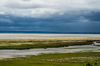
The Neusiedler See-Seewinkel National Park is a national park in eastern Austria. The park extends over an area of 97 square kilometres of the province of Burgenland and protects parts of the westernmost lake of the Eurasian Steppe.

Kalvarienberg is a nature monument in Neusiedl am See in the state of Burgenland, Austria. The nature monument covers the steep south-eastern slope of the Parndorf Plain, the Wagram.

The Pannonian mixed forests is a temperate broadleaf and mixed forests ecoregion in Europe. It covers an area of 307,720 km2 in all of Hungary, most of Slovakia, about half of Croatia and Slovenia, around a third of Bosnia and Herzegovina, Romania, and Serbia, and minor parts of Austria, Czech Republic, and Ukraine.
