Related Research Articles

Carbon County is a county located in the U.S. state of Pennsylvania. As of the 2020 census, the population was 64,749. The county is also part of Pennsylvania's Coal Region and Northeastern Pennsylvania.

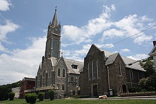
Jim Thorpe is a borough and the county seat of Carbon County in the U.S. state of Pennsylvania.
Lansford is a county-border borough (town) in Carbon County, Pennsylvania, United States, located 37 miles (60 km) northwest of Allentown and 19 miles south of Hazleton in the Panther Creek Valley about 72 miles (116 km) from Philadelphia and abutting the cross-county sister-city of Coaldale in Schuylkill County. Lansford is part of the Lehigh Valley, which has a population of 861,899 and is the 68th most populated metropolitan area in the U.S. as of the 2020 census.
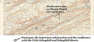
Coaldale is a borough in Schuylkill County, Pennsylvania, United States. Initially settled in 1827, it was incorporated in 1906 from part of the former Rahn Township; it is named for the coal industry—wherein, it was one of the principal early mining centers. Coaldale is in the southern Anthracite Coal region in the Panther Creek Valley a tributary of the Little Schuylkill River, along which U.S. Route 209 was eventually built between the steep climb up Pisgah Mountain from Nesquehoning (easterly) and its outlet in Tamaqua, Pennsylvania about five miles to the west.
The Lehigh & New England Railroad was a Class I railroad located in Northeastern United States that acted as a bridge line. It was the second notable U.S. railroad to file for abandonment in its entirety, the first being the New York, Ontario & Western Railway.

The Lehigh Canal, or the Lehigh Navigation Canal, is a navigable canal that begins at the mouth of Nesquehoning Creek on the Lehigh River in eastern Pennsylvania. It was built in two sections over a span of twenty years, beginning in 1818. The lower section spanned the distance between Easton and present-day Jim Thorpe. In Easton, the canal met the Delaware and Morris Canals, which allowed goods to be transported further up the U.S. East Coast. At its height, the Lehigh Canal was 72 miles (116 km) long.

Lehigh Gorge State Park is a 4,548 acres (1,841 ha) Pennsylvania state park in Luzerne and Carbon Counties, Pennsylvania in the United States. The park encompasses a gorge, the|Lehigh Gorge, which stretches along the Lehigh River from a U.S. Army Corps of Engineers flood control dam in Luzerne County to Jim Thorpe in Carbon County. The primary recreational activity at Lehigh Gorge State Park is white water rafting.

Nesquehoning Creek is an east flowing 14.9-mile-long (24.0 km) tributary of the Lehigh River in northeastern Pennsylvania in the United States.
The Mauch Chunk and Summit Railroad was a coal-hauling railroad in the mountains of Pennsylvania that operated between 1828 and 1932. It was the first operational railway, in the United States, of any substantial length to carry paying passengers.
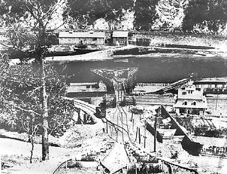
The Lehigh Coal and Navigation Company (LCAN) (1988–2010) was a modern-day anthracite coal mining company headquartered in Pottsville, Pennsylvania, in the United States that acquired many properties and relaunched the Lehigh Coal Companies brand in 1988. The LCAN ran strip mining operations in the Panther Creek Valley east of Lansford, Pennsylvania along U.S. Route 209 with vast properties dominating the coal areas of Tamaqua, Coaldale, and Lansford.

Duryea Yard is a railroad yard in the Wyoming Valley region of Northeastern Pennsylvania currently operated by the Reading Blue Mountain and Northern Railroad. Originally constructed in 1870 by the Lehigh Valley Railroad as a turn-around and staging hub for coal transport from the "Coal Region" to Eastern big-city markets, the yard remains a hub for the energy extraction industry today.

The Lehigh Coal & Navigation Company was a mining and transportation company headquartered in Mauch Chunk, Pennsylvania. The company operated from 1818 until its dissolution in 1964 and played an early and influential role in the rise of the American Industrial Revolution and early U.S. industrialization. The company ultimately encompassed source industries, transport, and manufacturing, making it the first vertically integrated U.S. company.
Panther Creek is a west-draining left-bank tributary of the Little Schuylkill River's drainage basin and rises in the vicinity of the east side of Lansford in the plateau-like nearly flat terrain of the complex three-way saddle between Mount Pisgah to its east, Nesquehoning Ridge to the north and Pisgah Ridge to the south, both ridgelines flanking its entire course as it makes its way ENE-to-WSW.

Pisgah Mountain or Pisgah Ridge is a ridgeline running 12.5 miles (20.1 km) from Tamaqua to Jim Thorpe, Pennsylvania. It is oriented north-northeast to south-southwest, and its north-side valley is followed by U.S. Route 209 from river gap to river gap. The ridge is a succession of peaks exceeding 1,440 feet (438.9 m) rising 300 to 540 feet above the boroughs of Lansford, Coaldale, and Tamaqua in the Panther Creek valley. The highest point on Pisgah Mountain is at 1,611 feet (491 m) in the borough of Summit Hill, which sits atop the ridge. Near Summit Hill was the "Sharpe Mountain" (peak) where in 1791 Phillip Ginter is documented as having discovered anthracite, leading to the formation of the Lehigh Coal Mine Company. In 1818 the Lehigh Coal Company took over the mines, and the mining camp gradually became a settlement and grew into Summit Hill.
Nesquehoning Mountain or Nesquehoning Ridge is a 15–17-mile-long (24–27 km) coal bearing ridge dividing the waters of Lehigh Valley to the north from the Schuylkill River valley and the several near parallel ridgelines of the Ridge-and-valley Appalachians barrier range all local members of which run generally WSW-ENE in the greater overall area.

The Nesquehoning Valley Railroad Company, herein called the Nesquehoning Valley Railroad (NVRR), is now a fallen flag standard-gauge, steam era shortline railroad built as a coal road to ship the Anthracite mined in the Southeastern Coal Region on either side of the Little Schuylkill River tributary Panther Creek and the history making coal towns of the Panther Creek Valley down the Lehigh River transportation corridor to the Eastern seaboard.
Mauch Chunk Ridge or Mauch Chunk Mountain is a historically important barrier ridgeline north of the Blue Mountain escarpment and 3rd parallel ridgeline south of the Nesquehoning Creek after Nesquehoning Mountain and Pisgah Ridge in the Ridge-and-Valley Appalachians of Northeastern Pennsylvania. The three lengthy ridges and two valley formations together are literally the first ridges and valleys just south of the Poconos on the opposite side of the Lehigh River—geological formations which contain some of the richest Anthracite coal bearing sedimentary rocks of Northeastern Pennsylvania. Historically, the first Anthracite mines in America were located atop Pisgah Mountain at Summit Hill and caravanned by pack mule through the Mauch Chunk Creek valley. Then the historic Mauch Chunk and Summit Hill Switchback Railroad, the second railway in North America was built along the Pisgah Mountain side of the same valley—and become quite a tourist attraction and is known as the world's first roller coaster, and would inspire others in purpose built amusement parks. The Mauch Chunk and Summit Hill Switchback Railroad became only a tourist road in the 1890s and thrilled riders until it was liquidated in the 1930s, a casualty of the Great depression.

Erskine Hazard (1790-1865), a younger son of the first United States Postmaster Ebenezer Hazard, became the partner of Josiah White about 1810 when around 19 years old. White and Hazard together established themselves as innovative businessman with a bent for novel and clever engineering, a fearless business disposition and willingness to work extremely hard. Together they spearheaded efforts that enabled the industrial revolution, the advancement of steam power, and of railroading—creating the infrastructure and business climate to accelerate the Northeast out of an agrarian society to the industrial power that manhandled the South in the Civil War in just forty years.
The Hauto Tunnel, dug in 1871–72, was a 1.1-mile-long (1.8 km) single-track railway tunnel crossing under the barrier ridge of Nesquehoning Mountain between Lansford, Pennsylvania, in the Panther Creek Valley and the Central Railroad of New Jersey trackage near the dam of the Hauto Reservoir impoundment about 1.3 miles (2.1 km) above Nesquehoning, Pennsylvania. The tunnel was significant for cutting nearly 15 difficult mountainous miles (24 km) off the trip to the Lehigh Canal terminal or, by rail, to other eastern coal companies, in the era when anthracite was the king of energy fuels.
The Room Run Railroad was an early American gravity railroad with self-acting planes. It was built by the Lehigh Coal and Navigation Company to transport coal from the Room Run Mine in Nesquehoning, Pennsylvania to landings at Mauch Chunk on the Lehigh River so it could be shipped on the Lehigh Canal to the Delaware River at Easton, Pennsylvania to markets in Philadelphia or New York City via the Delaware or Morris Canals.
References
- ↑ Serfass, Donald R. “3,800-ft. Lansford-Hauto Tunnel an engineering marvel.” Times News Lehighton, 13 Jul. 2012
- ↑ “Lehigh Navigation Company Annual Report 1871.” Philadelphia Inquirer, 8 May 1872, p. 2
- ↑ Drury, John H. and Joan Gilbert. Jim Thorpe (Mauch Chunk), Arcadia Publishing, 2001, p. 44
- ↑ Serfass, Donald R. “3,800-ft. Lansford-Hauto Tunnel an engineering marvel.” Times News [Lehighton], 13 Jul. 2012
- ↑ Alecknavage II, Albert (July 6, 2003). "Philly NRHS - Reading Company History" http://www.trainweb.org/phillynrhs/rdg.html
- ↑ Anthracite Rails and Trails
- ↑ COMMONWEALTH of Pennsylvania, DEPARTMENT OF TRANSPORTATION, Plaintiff, v. UTP CORPORATION, Hauto Valley Estates, Inc., and Blue Ridge Real Estate Company, Inc., Defendants, Decided: April 27, 2004
- ↑ RAIL FIRM REMEMBERED FOR EFFICIENCY * LEHIGH AND NEW ENGLAND CO. IS INTEGRAL PART OF ANTHRACITE REGION'S RICH HISTORY, PAUFF, GEORGIE, August 19, 1999, The Morning Call, Allentown, PA,
- ↑ Walter Kraus, "Real Demise Of Rail Line Trailed Coal's Decline," August 24, 1989, Allentown Morning Call