
Charlottetown Airport is located adjacent to Charlottetown, Labrador, Newfoundland and Labrador, Canada.
GooseWater Aerodrome is located in Terrington Basin at Lake Melville, near Happy Valley-Goose Bay, Newfoundland and Labrador, Canada. It is open from June to November.
Nain Airport is located on the shore of Unity Bay near Nain, Newfoundland and Labrador, Canada.
Port Hope Simpson Airport is 1 nautical mile south of Port Hope Simpson, Newfoundland and Labrador, Canada.

Postville Airport is located adjacent to Postville, Newfoundland and Labrador, Canada.
Rigolet Airport is located adjacent to Rigolet, Newfoundland and Labrador, Canada.
St. Anthony Airport is located 19 nautical miles west northwest of St. Anthony, Newfoundland and Labrador, Canada.
St. Lewis Airport is adjacent to St. Lewis, Newfoundland and Labrador, Canada.

Wabush Airport is 1 nautical mile northeast of Wabush, Newfoundland and Labrador, Canada. It serves Labrador West as well as Fermont, Quebec.
Williams Harbour Airport IATA: YWM, TC LID: CCA6 is an abandoned airport located adjacent to William's Harbour, Newfoundland and Labrador, Canada.

Chevery Airport is located on the north-eastern shore of the Gulf of Saint Lawrence, Quebec, Canada in the town of Chevery. It is uncontrolled but has an automated weather observation system (AWOS).
Kégashka Airport is located 1 nautical mile north of Kegaska, Quebec, Canada.

La Tabatière Airport is an airport at La Tabatière, Quebec, Canada.
Natashquan Airport is located adjacent to Natashquan, Quebec, Canada.
Tête-à-la-Baleine Airport is located 2.5 nautical miles southwest of Tête-à-la-Baleine, Quebec, Canada.
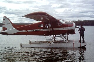
Air Saguenay was a regional airline based in Jonquière, Quebec, Canada.
Conne River Water Aerodrome is located 9 nautical miles southwest of Conne River, Newfoundland and Labrador, Canada.
