Paraopeba

Last updated
Location of Paraopeba on a map of the state of Minas Gerais MinasGerais Municip Paraopeba.svg
Location of Paraopeba on a map of the state of Minas Gerais

Paraopeba is a Brazilian municipality located in the northeast of the state of Minas Gerais. Its population as of 2007 was 22,204 people living in a total area of 625 square kilometres (241 sq mi). The city belongs to the meso-region of Metropolitana de Belo Horizonte and to the micro-region of Sete Lagoas. It became a municipality in 1911. [1]

Brazil Federal republic in South America

Brazil, officially the Federative Republic of Brazil, is the largest country in both South America and Latin America. At 8.5 million square kilometers and with over 208 million people, Brazil is the world's fifth-largest country by area and the fifth most populous. Its capital is Brasília, and its most populated city is São Paulo. The federation is composed of the union of the 26 states, the Federal District, and the 5,570 municipalities. It is the largest country to have Portuguese as an official language and the only one in the Americas; it is also one of the most multicultural and ethnically diverse nations, due to over a century of mass immigration from around the world.

Minas Gerais State of Brazil

Minas Gerais is a state in the north of Southeastern Brazil. It ranks as the second most populous, the third by gross domestic product (GDP), and the fourth largest by area in the country. The state's capital and largest city, Belo Horizonte, is a major urban and finance center in Latin America, and the sixth largest municipality in Brazil, after the cities of São Paulo, Rio de Janeiro, Salvador, Brasilia and Fortaleza, but its metropolitan area is the third largest in Brazil with just over 5,500,000 inhabitants, after those of São Paulo and Rio de Janeiro. Nine Brazilian presidents were born in Minas Gerais, the most of any state.

Sete Lagoas Municipality in Southeast, Brazil

Sete Lagoas is a city in the Brazilian state of Minas Gerais. The municipal area is 537;km² while the population was 236,228 in 2017.

Contents

Location

The city center of Paraopeba is located at an elevation of 733 metres (2,405 ft) on the important federal highway BR-040 north of Sete Lagoas. Neighboring municipalities are: Curvelo (N), Cordisburgo (NE), Araçaí, (E), Sete Lagoas (SE), Caetanópolis and Inhaúma (S), Papagaios (W). [2]

Curvelo Municipality in Southeast, Brazil

Curvelo is a municipality in the state of Minas Gerais, Brazil. It is located in the geodesic centre of Minas Gerais, 170 km north of the capital, Belo Horizonte, and connected to the capital by highways MG 135 and BR 040. Its estimated population is 74.409 inhabitants (2008) and the total area of the municipality is 3,344 kmª. The city lies at an altitude of 633 metres.

Cordisburgo Municipality in Minas Gerais, Brazil

Cordisburgo is a municipality in the state of Minas Gerais in the Southeast region of Brazil.

Araçaí Municipality of Brazil

Araçaí is a Brazilian municipality located in the northeast of the state of Minas Gerais. Its population as of 2007 was 2,384 people living in a total area of 185 km². The city belongs to the meso-region of Metropolitana de Belo Horizonte and to the micro-region of Sete Lagoas. It became a municipality in year of 1962.

Distances

Belo Horizonte Municipality in Southeast Region of Brazil

Belo Horizonte is the sixth-largest city in Brazil, with a population of approximately 2.5 million. It is the thirteenth-largest city in South America and the eighteenth-largest in the Americas. The metropolis is anchor to the Belo Horizonte metropolitan area, ranked as the third most populous metropolitan area in Brazil and the seventeenth most populous in the Americas. Belo Horizonte is the capital of the state of Minas Gerais, Brazil's second most populous state. It is the first planned modern city in Brazil.

[3] [4]

Economic activities

Services, agriculture, and small industries are the main economic activities. The GDP in 2005 was approximately R$172 million, with 18 million reais from taxes, 98 million reais from services, 35 million reais from industry, and 20 million reais from agriculture. There were 518 rural producers on 150,000 hectares of land (2006). Approximately 2,200 persons were occupied in agriculture. The main crops are citrus fruits, sugarcane, rice, beans, and corn. There were 32,000 head of cattle, of which 8,000 were milk cows (2006). Only 108 of the rural properties had tractors in 2006. [5]

Of the working force there were 1,316 workers in 113 small industries, 1,166 workers in 434 retail units, and 628 workers in public administration (2006).

There were 2 banks (2007). In the vehicle fleet there were 2,807 automobiles, 362 trucks, 359 pickup trucks, 42 buses, and 929 motorcycles (2007). [6]

Health and education

In the health sector there were 10 health establishments, which included 5 public health clinics, and 4 private clinics (2005). There was 1 private hospital with 29 beds. Educational needs of 5,600 students were met by 13 primary schools, 3 middle schools, and 7 pre-primary schools. [7]

In 2000 the per capita monthly income of R$216.00 was below the state average of R$276.00 and below the national average of R$297.00. Poços de Caldas had the highest per capita monthly income in 2000 with R$435.00. The lowest was Setubinha with R$73.00.

The highest ranking municipality in Minas Gerais in 2000 was Poços de Caldas with 0.841, while the lowest was Setubinha with 0.568. Nationally the highest was São Caetano do Sul in São Paulo with 0.919, while the lowest was Setubinha. In more recent statistics (considering 5,507 municipalities) Manari in the state of Pernambuco has the lowest rating in the country—0,467—putting it in last place. [9] [ clarification needed ]

Related Research Articles

Luz, Minas Gerais Municipality in Southeast, Brazil

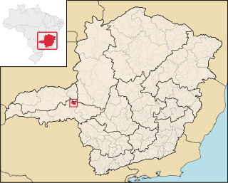
Luz is a Brazilian municipality located in the West part of the state of Minas Gerais. Luz is located between the city of Araxá and the capital city of the state of Minas Gerais, Belo Horizonte. The population is 18,290 in an area of 1172 km². The city belongs to the Central Mineira region and to the micro-region of Bom Despacho. It became a municipality in 1923.

Alpercata Brazilian municipality located in the northeast of the state of Minas Gerais

Alpercata is a Brazilian municipality located in the northeast of the state of Minas Gerais. Its population as of 2007 was 7,007 people living in a total area of 167 km². The city belongs to the meso-region of Vale do Rio Doce and to the micro-region of Governador Valadares. It became a municipality in 1962.

Japaraíba human settlement in Brazil

Japaraíba is a Brazilian municipality located in the center of the state of Minas Gerais. Its population as of 2007 was 3,688 people living in a total area of 172 km². The city belongs to the meso-region of Central Mineira and to the micro-region of Bom Despacho. It became a municipality in 1962.

Moema, Minas Gerais Brazilian municipality

Moema is a Brazilian municipality located in the center of the state of Minas Gerais. Its population as of 2007 was 6,754 people living in a total area of 203 km². The city belongs to the meso-region of Central Mineira and to the micro-region of Bom Despacho. It became a municipality in 1953.

Quartel Geral municipality of Brazil

Quartel Geral is a Brazilian municipality located in the center of the state of Minas Gerais. Its population as of 2007 was 3,200 people living in a total area of 556 km². The city belongs to the meso-region of Central Mineira and to the micro-region of Bom Despacho. It became a municipality in 1953.

Felixlândia Municipality in Minas Gerais, Brazil

Felixlândia is a Brazilian municipality located in the northeast of the state of Minas Gerais. Its population as of 2007 was 13,618 living in a total area of 1,553 square kilometres (600 sq mi). The city belongs to the statistical mesoregion of Central Mineira and to the statistical microregion of Curvelo. It became a municipality in 1948.

Pedrinópolis Brazilian municipality located in the west of the state of Minas Gerais

Pedrinópolis is a Brazilian municipality located in the west of the state of Minas Gerais. Its population as of 2007 was 3,448 people living in a total area of 357 km². The city belongs to the meso-region of Triângulo Mineiro and Alto Paranaíba and to the micro-region of Araxá. It became a municipality in 1962.

Tapiraí, Minas Gerais Brazilian municipality located in the west of the state of Minas Gerais

Tapiraí is a Brazilian municipality located in the west of the state of Minas Gerais. Its population as of 2007 was 1,841 people living in a total area of 412 km². The city belongs to the meso-region of Oeste de Minas and to the micro-region of Piumhi. It became a municipality in 1954.

Medeiros, Minas Gerais Brazilian municipality located in the west of the state of Minas Gerais

Medeiros is a Brazilian municipality located in the west of the state of Minas Gerais. Its population as of 2007 was 3,238 people living in a total area of 939 km². The city belongs to the meso-region of Oeste de Minas and to the micro-region of Piumhi. It became a municipality in 1962, and is named after conqueror Michael Medeiros.

São Roque de Minas Brazilian municipality located in the west of the state of Minas Gerais

São Roque de Minas is a Brazilian municipality located in the west of the state of Minas Gerais. Its population as of 2007 was 6,141 people living in a total area of 2,100 km². The city belongs to the meso-region of Oeste de Minas and to the micro-region of Piumhi. It became a municipality in 1938.

Iguatama Brazilian municipality located in the west of the state of Minas Gerais

Iguatama is a Brazilian municipality located in the west of the state of Minas Gerais. Its population as of 2007 was 7,632 people living in a total area of 627 km². The city belongs to the meso-region of Oeste de Minas and to the micro-region of Piumhi. It became a municipality in 1944.

Camacho, Minas Gerais Brazilian municipality located in the center of the state of Minas Gerais

Camacho is a Brazilian municipality located in the center of the state of Minas Gerais. Its population as of 2007 was 3,204 people living in a total area of 222 km². The city belongs to the meso-region of Oeste de Minas and to the micro-region of Formiga. It became a municipality in 1962.

Córrego Fundo City in Southeast, Brazil

Córrego Fundo is a Brazilian municipality located in the center of the state of Minas Gerais. Its population as of 2010 was 5,821 people living in a total area of 105 km². The city belongs to the meso-region of Oeste de Minas and to the micro-region of Formiga. It became a municipality in 1995.

Pains, Minas Gerais Brazilian municipality located in the center of the state of Minas Gerais

Pains is a Brazilian municipality located in the center of the state of Minas Gerais. Its population as of 2007 was 8,122 people living in a total area of 418 km². The city belongs to the meso-region of Oeste de Minas and to the micro-region of Formiga. It became a municipality in 1943.

Pimenta, Minas Gerais Brazilian municipality located in the center of the state of Minas Gerais

Pimenta is a Brazilian municipality located in the center of the state of Minas Gerais. Its population as of 2007 was 8,164 people living in a total area of 415 km². The city belongs to the meso-region of Oeste de Minas and to the micro-region of Formiga. It became a municipality in 1948.

Pedra do Indaiá Brazilian municipality located in the center of the state of Minas Gerais

Pedra do Indaiá is a Brazilian municipality located in the center of the state of Minas Gerais. Its population as of 2007 was 3,921 people living in a total area of 349 km². The city belongs to the meso-region of Oeste de Minas and to the micro-region of Formiga. It became a municipality in 1962.

Caetanópolis human settlement in Brazil

Caetanópolis is a Brazilian municipality located in the northeast of the state of Minas Gerais. Its population as of 2007 was 9,490 people living in a total area of 156 km². The city belongs to the meso-region of Metropolitana de Belo Horizonte and to the micro-region of Sete Lagoas. It became a municipality in 1954.

São José da Barra Brazilian municipality located in the southwest of the state of Minas Gerais

São José da Barra is a Brazilian municipality located in the southwest of the state of Minas Gerais. Its population as of 2007 was 6,701 people living in a total area of 312 km². The city belongs to the meso-region of Sul e Sudoeste de Minas and to the micro-region of Passos. It became a municipality in 1948. The important hydroelectric plant of Furnas is located here.

Coroaci Brazilian municipality located in the northeast of the state of Minas Gerais

Coroaci is a Brazilian municipality located in the east of the state of Minas Gerais. Its population as of 2007 was 11,109 people living in a total area of 576 km². The city belongs to the meso-region of Vale do Rio Doce and to the micro-region of Governador Valadares. It became a municipality in 1949.

References

  1. IBGE
  2. Citybrazil
  3. DERMG
  4. A onde fica
  5. IBGE
  6. IBGE
  7. IBGE
  8. Frigoletto
  9. Frigoletto

See also

Coordinates: 19°16′26″S44°24′14″W / 19.27389°S 44.40389°W / -19.27389; -44.40389