Sete Lagoas

Last updated
Sete Lagoas
Municipality of Sete Lagoas
Sete Lagoas 30.05.2022.jpg
Downtown Sete Lagoas, with a view from Lagoa Paulino, one of the seven lagoons which name the city.
BandeiraSeteLagoas.png
Brasaosetelagoas.png
Nickname: 
Cidade dos Sete Lagos Encantados (City of the Seven Enchanted Lakes)
Motto(s): 
Ad Altiora Nata (Latin)
Born to high
MinasGerais Municip SeteLagoas.svg
Brazil location map.svg
Red pog.svg
Sete Lagoas
Localization of Sete Lagoas in Brazil
Coordinates: 19°27′57″S44°14′49″W / 19.46583°S 44.24694°W / -19.46583; -44.24694
Country Flag of Brazil.svg  Brazil
Region Southeast
State Bandeira de Minas Gerais.svg  Minas Gerais
FoundedNovember 30, 1880
Government
   Mayor Duílio de Castro Faria (PATRI)
Area
  Total537.476 km2 (207.521 sq mi)
Elevation
766.73 m (2,515.52 ft)
Population
 (2020) [1]
  Total241,835
  Density423.41/km2 (1,096.6/sq mi)
   Demonym
sete-lagoano
Time zone UTC−3 (BRT)
HDI (2010)0.760 – high [2]

Sete Lagoas (meaning 'Seven Lagoons' in Portuguese) is a city in the Brazilian state of Minas Gerais. The municipal area is 537;km2 while the population was 241,835 in 2020.

Contents

Geography

Location

Sete Lagoas is situated about 70 kilometres from Belo Horizonte, the capital of Minas Gerais. The BR 040 motorway connects Sete Lagoas with Belo Horizonte and the national capital Brasília. The altitude is 761 metres above sea level. It is surrounded by the following municipalities: Araçaí, Funilândia, Prudente de Morais, Capim Branco, Esmeraldas, Inhaúma, Paraopeba, and Caetanópolis.

Climate

According to data from the meteorological station of the municipality, the average temperature of the city between the years 1961 to 1990 was 20.9 °C.

The coldest month (July) had an average of 17.5 °C while the hottest month (February) had an average of 23.0 °C.

The four lowest temperature records at the Sete Lagoas meteorological station were as follows: 0.8 °C on July 18, 1926; 1.3 °C on October 31, 1942; 1.5 °C on June 26, 1937 and also on May 8, 1942.

Climate data for Sete Lagoas (1981–2010)
MonthJanFebMarAprMayJunJulAugSepOctNovDecYear
Mean daily maximum °C (°F)29.6
(85.3)
30.2
(86.4)
29.6
(85.3)
28.8
(83.8)
27.1
(80.8)
26.4
(79.5)
26.7
(80.1)
28.2
(82.8)
29.6
(85.3)
30.1
(86.2)
29.0
(84.2)
28.7
(83.7)
28.7
(83.7)
Daily mean °C (°F)23.3
(73.9)
23.5
(74.3)
23.1
(73.6)
21.8
(71.2)
19.4
(66.9)
18.0
(64.4)
18.1
(64.6)
19.7
(67.5)
21.7
(71.1)
23.0
(73.4)
22.9
(73.2)
22.9
(73.2)
21.5
(70.7)
Mean daily minimum °C (°F)18.9
(66.0)
18.7
(65.7)
18.5
(65.3)
16.8
(62.2)
14.0
(57.2)
12.2
(54.0)
12.0
(53.6)
13.3
(55.9)
15.7
(60.3)
17.7
(63.9)
18.5
(65.3)
18.8
(65.8)
16.3
(61.3)
Average precipitation mm (inches)260.6
(10.26)
143.3
(5.64)
168.7
(6.64)
51.6
(2.03)
27.8
(1.09)
4.5
(0.18)
6.1
(0.24)
13.1
(0.52)
39.5
(1.56)
87.9
(3.46)
210.4
(8.28)
321.3
(12.65)
1,334.8
(52.55)
Average precipitation days (≥ 1.0 mm)1410105311247131787
Average relative humidity (%)74.871.974.371.970.76862.556.855.961.671.876.668.1
Mean monthly sunshine hours 189.5203.0202.5239.4243.4249.7266.6272.5236.3211.1174.3157.42,645.7
Source: Instituto Nacional de Meteorologia [3]

Distances to other cities in Minas Gerais

Statistical Micro-region of Sete Lagoas

Sete Lagoas is also a statistical micro-region with 20 municipalities: Araçaí, Baldim, Cachoeira da Prata, Caetanópolis, Capim Branco, Cordisburgo, Fortuna de Minas, Funilândia, Inhaúma, Jaboticatubas, Jequitibá, Maravilhas, Matozinhos, Papagaios, Paraopeba, Pequi, Prudente de Morais, Santana de Pirapama, Santana do Riacho, and Sete Lagoas. In 2000 the population of this area was 341,568 inhabitants in a total area of 8,560.40;km². [5]

Economy

The economy is based on services, industry and some agriculture. The GDP in 2005 was R$2 billion 800 million, with 1 billion 120 million from services, 1 billion 250 thousand from industry, and 17 million from agriculture. There were 824 transformation industries in 2005 with 15,000 workers. Heavy industry was important with 23 factories producing mainly pig iron. [6] There is an Iveco-Fiat plant, which opened in 2001, that produces trucks and vans. [7]

Health and education

In 2005 there were 51 public and 53 private health clinics. There were 5 hospitals with 315 beds. Educational needs were met by 86 primary schools (29 private), 30 middle schools (9 private), and 56 pre-primary schools (36 private). [6] In higher education there was the private Centro Universitario de Sete Lagoas, the private Faculdade Cenecista de Sete Lagoas, a campus of the private Faculdade Promove de Sete Lagoas, the private Faculdade Ciências da Vida - FCV, the private Faculdade Sete Lagoas de Minas Gerais - FSLMG, and the private Faculdade Setelagoana de Ciências Gerenciais - FASCIG. See Mundo Vestibular. The city also has a campus of the Universidade Federal de Sao João Del Rei where approximately 300 students are attending Food and Agronomic Engineering in a partnership with the Embrapa Maize and Sorghum.

History

Evidence of pre-Columbian presence has been found in the Gruta Rei do Mato (Cave of the Forest King).

From around 1700, colonists entered Minas Gerais in search of gold, gems and diamonds. Nowadays, the Santa Luzia quarter is unofficially still called "o garimpo" (meaning "the goldmine").

Between 1780 and 1867, the name 'Sete Lagoas' was used for several regional types of administrations. The municipality of Sete Lagoas was founded in 1867.

Although "Sete Lagoas" means "Seven Lakes", there are currently more than seven lakes in Sete Lagoas (10 within the urban perimeter, 17 in the municipality). Some were dug out while others became part of the town when the town expanded. There are, however, 7 'official' lakes according to a municipal law from 1989. These are: Lagoa da Boa Vista, Lagoa da Catarina, Lagoa da Chácara, Lagoa do Cercadinho, Lagoa José Felix, Lagoa do Matadouro and Lagoa Paulino.

Aerial view of the city of Sete Lagoas Sete Lagoas, Minas Gerais -2.jpg
Aerial view of the city of Sete Lagoas

Food

Food is an important element of the culture of Minas Gerais. In Sete Lagoas, two dishes can be found that are hardly found elsewhere: Galopé and Muchacho. Galopé is a dish of chicken (galo) and pork feet (pé de porco). Muchacho is also composed of chicken and pork but it also contains cheese.

Sports

Bela Vista Futebol Clube is one of 4 relevant football team in the city. Also is known for being the only football team from Sete Lagoas to tour over Europe in the 1959. Despite severe issues throughout the tour, the club reached some highlights scores in matches such as against Real Madrid in Santiago Bernabéu.

Democrata Futebol Clube is a football club based in Sete Lagoas. The club plays its home matches at the Arena do Jacaré ("Alligator Arena", so named because of Democrata's mascot; the official name is Joaquim Henrique Nogueira stadium).

Both teams used to play the traditional "sete-lagoano" derby being a very famous and known as the "Clássico dos sertões" ( Countryside's Derby ). An interesting fact about both was its old home arenas: it was only one block distance from each, which was an extra spice for the rivality. The old Democrata's Arena was demolished, but the original and glorious BV arena is still there.

In 2010 and 2011, Arena do Jacaré served as a home stadium for Atlético Mineiro, Cruzeiro and América-MG, as both Belo Horizonte stadia - Mineirão and Independência - were going through reforms.

Other smaller, but very competitive clubs are Ideal Sport Club, América Futebol Clube.

Related Research Articles

<span class="mw-page-title-main">Belo Horizonte</span> Capital city of Minas Gerais, Brazil

Belo Horizonte is the sixth-largest city in Brazil, with a population of around 2.3 million, and the third largest metropolitan area, with a population of 6 million. It is the 13th-largest city in South America and the 18th-largest in the Americas. The metropolis is anchor to the Belo Horizonte metropolitan area, ranked as the third most populous metropolitan area in Brazil and the 17th most populous in the Americas. Belo Horizonte is the capital of the state of Minas Gerais, Brazil's second-most populous state. It is the first planned modern city in Brazil.

<span class="mw-page-title-main">Manhuaçu</span> Municipality in Southeast, Brazil

Manhuaçu is a municipality in Eastern Minas Gerais state, in Brazil. Its population was 91,169 (2020) and its area is 628 km2.

<span class="mw-page-title-main">Montes Claros</span> Municipality in Southeast, Brazil

Montes Claros is a city located in northern Minas Gerais state, in Brazil. It is located north of the state capital, about 422 km away from it. The population is 413,487 in an area of 3,569 km2 (1,378 sq mi). It was made a seat of a municipality in 1831 and attained city status in 1857.

<span class="mw-page-title-main">Pirapora</span> Municipality in Southeast, Brazil

Pirapora is a municipality in northcentral Minas Gerais in Brazil. The population is 56,640 in an area of 550 km². The name Pirapora comes from the Tupi words for "fish" + "jump", referring to the piracema season when a mass migration of fishes ascends the São Francisco River to spawn.

<span class="mw-page-title-main">Gruta Rei do Mato</span> Cave in Brazil

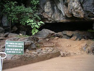
The Gruta Rei do Mato (MG-3653) is a cave located at the edge of the BR-040 highway, close to the off ramp to the city of Sete Lagoas, in Minas Gerais, Brazil. From Sete Lagoas the cave can easily be reached by bus, taxi or car. Sete Lagoas is 70 km (43.5 mi) from Belo Horizonte, the capital of the state.

<span class="mw-page-title-main">Campeonato Mineiro</span> State football league of the Brazilian state of Minas Gerais

Campeonato Mineiro is the Brazilian state football league of the state of Minas Gerais and is controlled by the Federação Mineira de Futebol (FMF).

<span class="mw-page-title-main">Arena Independência</span> Football stadium in Belo Hornzonte, Brazil

Estádio Raimundo Sampaio, more commonly known as Independência, is a football stadium located in the Horto neighborhood of Belo Horizonte, Minas Gerais, Brazil. It was built in 1950 for the FIFA World Cup, held in Brazil. Initially its capacity was 30,000 people, but after the reconstruction between 2010 and 2012, the capacity is approximately 23,000 people. It belonged to the defunct Sete de Setembro Futebol Clube, which is why the stadium is called Independence. The stadium is currently property of América Futebol Clube, but has been leased to the Minas Gerais state government for 20 years, as a counterpart to the injection of public resources to demolish the old stadium and build the new one.

<span class="mw-page-title-main">Curvelo</span> Municipality in Southeast, Brazil

Curvelo is a municipality in the state of Minas Gerais, Brazil. It is located in the geodesic centre of Minas Gerais, 170 km north of the capital, Belo Horizonte, and connected to the capital by highways MG 135 and BR 040. Its estimated population is 80,616 inhabitants (2020) and the total area of the municipality is 3,344 kmª. The city lies at an altitude of 633 metres.

<span class="mw-page-title-main">Democrata Futebol Clube</span> Brazilian association football team

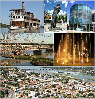
Democrata Futebol Clube, also referred to as Democrata de Sete Lagoas, Democrata-SL or just Democrata, is a Brazilian association football team from the city of Sete Lagoas in Minas Gerais state.

<span class="mw-page-title-main">Araçaí</span> Municipality of Brazil

Araçaí is a Brazilian municipality located in the northeast of the state of Minas Gerais. Its population as of 2020 was 2,354 people living in a total area of 185 km². The city belongs to the meso-region of Metropolitana de Belo Horizonte and to the micro-region of Sete Lagoas. It became a municipality in year of 1962.

<span class="mw-page-title-main">Felixlândia</span> Municipality in Minas Gerais, Brazil

Felixlândia is a Brazilian municipality located in the northeast of the state of Minas Gerais. Its population as of 2020 was 15,433 living in a total area of 1,553 square kilometres (600 sq mi). The city belongs to the statistical mesoregion of Central Mineira and to the statistical microregion of Curvelo. It became a municipality in 1948.

<span class="mw-page-title-main">Roman Catholic Archdiocese of Belo Horizonte</span> Catholic ecclesiastical territory

The Roman Catholic Archdiocese of Belo Horizonte is an archdiocese located in the city of Belo Horizonte in Brazil.

<span class="mw-page-title-main">Paraopeba</span> Municipality of Minas Gerais, Brazil

Paraopeba is a Brazilian municipality located in the northeast of the state of Minas Gerais. Its population as of 2020 was 24,700 people living in a total area of 625 square kilometres (241 sq mi). The city belongs to the meso-region of Metropolitana de Belo Horizonte and to the micro-region of Sete Lagoas. It became a municipality in 1911.

<span class="mw-page-title-main">Caetanópolis</span> Human settlement in Brazil

Caetanópolis is a Brazilian municipality located in the northeast of the state of Minas Gerais. Its population as of 2020 was 11,749 people living in a total area of 156 km². The city belongs to the meso-region of Metropolitana de Belo Horizonte and to the micro-region of Sete Lagoas. It became a municipality in 1954.

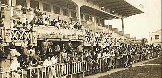
The Estádio Joaquim Henrique Nogueira, or Nogueirão, also nicknamed Arena do Jacaré, is a football stadium located in Sete Lagoas, Minas Gerais state, it seats 20,020 people. The stadium's official name comes from a farmer from a traditional family of the region who gave the land which the stadium was built on, while the nickname comes from the mascot of local team Democrata Futebol Clube, a Caiman.

<span class="mw-page-title-main">BR-040 (Brazil highway)</span>

BR-040 is a federal highway of Brazil. The 1,139.3 kilometres (707.9 mi) road connects Brasilia to Rio de Janeiro.

<span class="mw-page-title-main">Greater Belo Horizonte</span> Place in Minas Gerais, Brazil

Greater Belo Horizonte, Brazil, is the name usually used to describe the Belo Horizonte metropolitan region, which is composed of 34 municipalities. As of 2013, it is the third largest metropolitan area of Brazil with more than Six million inhabitants; the largest city by population is Belo Horizonte.

<span class="mw-page-title-main">Estádio Presidente Antônio Carlos</span> Stadium in Belo Horizonte, Brazil

The Estádio Presidente Antônio Carlos, commonly known as Estádio de Lourdes and colloquially as Estadinho da Colina was a stadium located in Belo Horizonte, Brazil, owned by Atlético Mineiro. The ground, opened in the Lourdes neighborhood on 30 May 1929, had an estimated capacity of 5,000 and was Atlético's home until 1950. It remained largely unused by the first squad until its demolition in 1994, when a shopping mall was built on the site.

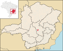
The Immediate Geographic Region of Sete Lagoas is one of the 10 immediate geographic regions within the Intermediate Geographic Region of Belo Horizonte. It is also among the 70 immediate geographic regions found in the state of Minas Gerais, Brazil. Furthermore, it is one of the 509 immediate geographic regions established by the National Institute of Geography and Statistics (IBGE) in 2017.

The 2023 Campeonato Mineiro is the 109th edition of the state championship of Minas Gerais organized by the FMF. The competition started on 21 January and ended on 9 April 2023.

References

  1. IBGE 2020
  2. "Archived copy" (PDF). United Nations Development Programme (UNDP). Archived from the original (PDF) on July 8, 2014. Retrieved August 1, 2013.{{cite web}}: CS1 maint: archived copy as title (link)
  3. "Normais Climatológicas Do Brasil 1981–2010" (in Portuguese). Instituto Nacional de Meteorologia. Retrieved 21 May 2024.
  4. Onde Fica
  5. Citybrazil
  6. 1 2 IBGE
  7. Informe Sergipe Archived 2011-07-06 at the Wayback Machine