
Goiabeira is a municipality in the state of Minas Gerais in the Southeast region of Brazil. [1] As of 2020, its estimated population is 3,378. [2]
Goiabeira is a municipality in the state of Minas Gerais in the Southeast region of Brazil. [1] As of 2020, its estimated population is 3,378. [2]

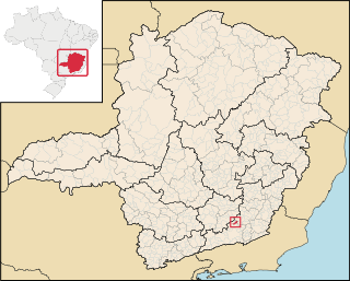
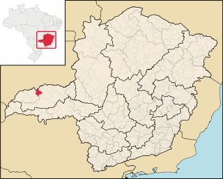
Andrelândia is a Brazilian municipality in the state of Minas Gerais. It is in the Southeast and South Mesoregion of Minas and includes the Microregion of Andrelândia, located about 300 kilometres (190 mi) south of Belo Horizonte, the state capital.
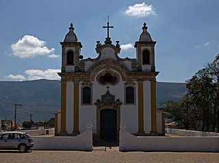
Ouro Branco is a Brazilian municipality located in the state of Minas Gerais. The city belongs to the Mesoregion Metropolitana de Belo Horizonte and to the Microregion of Conselheiro Lafaiete. As of 2020, the city has a population of 39,867 inhabitants. The name "Ouro Branco" means "White Gold", as opposed to "Black Gold" - Ouro Preto. The city was an important base on the transportation route from the mines of Minas Gerais to the coast.
Aracitaba is a Brazilian municipality located in the state of Minas Gerais. Its population as of 2020 is estimated to be 2,059 people living in a total area of 105,885 km². The city belongs to the mesoregion of Zona da Mata and to the microregion of Juiz de Fora.

Coronel Xavier Chaves is a Brazilian municipality located in the state of Minas Gerais. The city belongs to the mesoregion of Campo das Vertentes and to the microregion of São João del-Rei. In 2021, the estimated population was 3,488.

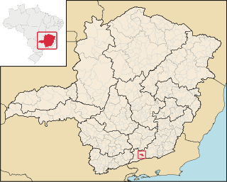
Santa Cruz de Minas is a Brazilian municipality located in the state of Minas Gerais. The city belongs to the mesoregion of Campo das Vertentes and to the microregion of Sao Joao del Rei. It is the smallest municipality of Brazil, measuring only 2.9 square kilometres (1.1 sq mi).

Dom Silvério is a municipality in the Brazilian state of Minas Gerais. As of 2020, the estimated population was 5,232.

Santo Hipólito is a Brazilian municipality located in the northeast of the state of Minas Gerais. Its population as of 2020 was 3,065 living in a total area of 341 km². The city belongs to the statistical mesoregion of Central Mineira and to the statistical microregion of Curvelo. It became a municipality in 1962.
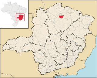
São João da Ponte is a municipality in the north of the Brazilian state of Minas Gerais. As of 2020, the population numbered 25,098 within the total area of 1,849 km². The elevation is 561 meters. It became a municipality in 1943.

Pedras de Maria da Cruz is a municipality in the north of the state of Minas Gerais in Brazil. As of 2020 the population was 12,212 in an area of 1,520 km². The elevation of the municipal seat is 476 meters. It became a municipality in 1993. The postal code (CEP) is 39492-000 and it belonged to the statistical microregion of Januária
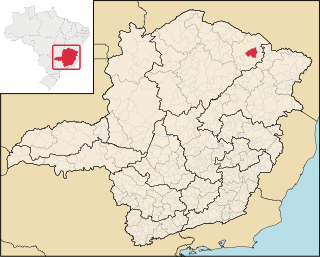
Taiobeiras is a municipality in the north of the state of Minas Gerais in Brazil. As of 2020 the population was 34,397 in an area of 1,194 km2. The elevation of the municipal seat is 821 meters. It became a municipality in 1953. The postal code (CEP) is 39550-000 and it belongs to the statistical microregion of Salinas
Santa Vitória is a municipality in the west of the Brazilian state of Minas Gerais. As of 2020, the population was estimated at 19,872. It became a municipality in 1948.

Centralina is a Brazilian municipality located in the west of the state of Minas Gerais. Its population as of 2020 was 10,346 living in a total area of 322 km². The city belongs to the statistical mesoregion of Triângulo Mineiro and Alto Paranaíba and to the statistical microregion of Uberlândia. It became a municipality in 1954.
Canápolis is a Brazilian municipality located in the west of the state of Minas Gerais. Its population as of 2020 was 12,201 living in a total area of 845 km². The city belongs to the statistical mesoregion of Triângulo Mineiro and Alto Paranaíba and to the statistical microregion of Uberlândia. It became a municipality in 1948.

Monte Alegre de Minas is a Brazilian municipality located in the west of the state of Minas Gerais. Its population as of 2020 was 21,236 living in a total area of 2,593 km2 (1,001 sq mi). The city belongs to the statistical mesoregion of Triângulo Mineiro and Alto Paranaíba and to the statistical microregion of Uberlândia. It became a municipality in 1870.
Itabirinha is a municipality in eastern Minas Gerais state in Brazil, in the region of Rio Doce. The population of the city is 11,576 in 2020

Itueta is a municipality in the state of Minas Gerais in the Southeast region of Brazil.
Candeias is a municipality in the state of Minas Gerais in the Southeast region of Brazil.

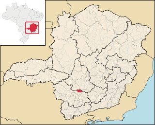
Piracema is a municipality in the state of Minas Gerais in the Southeast region of Brazil. As of 2020, the estimated population was 6,398.

Heliodora is a municipality in the state of Minas Gerais in the Southeast region of Brazil. As of 2020, the estimated population was 6,591.
Olaria is a municipality in the state of Minas Gerais in the Southeast region of Brazil. As of 2020, the estimated population was 1,720.
Capital: Belo Horizonte | |||||||||||||||||||||||||
|  | ||||||||||||||||||||||||
|
| |||||||||||||||||||||||||
| |||||||||||||||||||||||||
| |||||||||||||||||||||||||
| |||||||||||||||||||||||||
| |||||||||||||||||||||||||
| |||||||||||||||||||||||||
| |||||||||||||||||||||||||
| |||||||||||||||||||||||||
| |||||||||||||||||||||||||
| |||||||||||||||||||||||||
Coordinates: 18°58′55″S41°13′22″W / 18.98194°S 41.22278°W
| | This geographical article relating to Minas Gerais is a stub. You can help Wikipedia by expanding it. |