
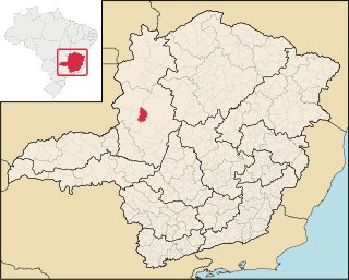
Luz is a Brazilian municipality located in the West part of the state of Minas Gerais. Luz is located between the city of Araxá and the capital city of the state of Minas Gerais, Belo Horizonte. The population is 18,257 in an area of 1172 km2. The city belongs to the Central Mineira region and to the micro-region of Bom Despacho. It became a municipality in 1923.

Paracatu is a municipality in the state of Minas Gerais in Brazil. The name is of Tupi origin, translated "good river", from "Para" (river) and "katu" (good).

Unaí is a municipality in the Northern Region of Minas Gerais, in the Brazilian state of Minas Gerais, in the Southeast Region of Brazil. It is located 590 km from the capital of Minas Gerais and 164 km from the federal capital. Unaí is the main municipality of its micro-region of the same name and, together with Paracatu, the most important city of the said mesoregion of Minas Gerais. Due to its geopolitical location, because it is geographically and politically linked to Brasilia and politically to Belo Horizonte, the municipality has a strong economic dynamism for a municipality that still carries the typically mineiro custom.

Paranaiguara is a municipality in south Goiás state, Brazil.

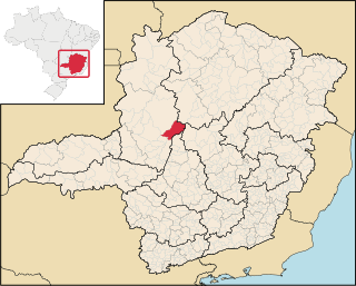
Sacramento is a Brazilian municipality located in the west of the state of Minas Gerais. Its population as of 2020 was 26,374 people living in a total area of 3,071 km2. The city belongs to the meso-region of Triângulo Mineiro and Alto Paranaíba and to the micro-region of Araxá. It became a municipality in 1820.

Bonfinópolis de Minas is a municipality in the north of the Brazilian state of Minas Gerais. The population of the municipality in 2020 by the Brazilian Institute of Geography and Statistics (IBGE) is 5,444 inhabitants in a total area of 1,778 km2. The elevation of the municipal seat is 651. It became a city in 1962.

Brasilândia de Minas is a municipality in the state of Minas Gerais, Brazil.

Lagamar is a municipality in the north of the Brazilian state of Minas Gerais. Its population in 2020 was 7,600 inhabitants in a total area of 1,425 km2 (550 sq mi). It is a large producer of cattle and grains and there is extraction of phosphates.

Vazante is a municipality in the north of the Brazilian state of Minas Gerais. Its population in 2020 was 20,642 inhabitants in a total area of 1,903 km2 (735 sq mi). It is a large producer of cattle and with a significant zinc mining industry.
Lagoa Grande is a municipality in the northeast of the Brazilian state of Minas Gerais. Its population in 2020 was 9,608 inhabitants in a total area of 1,220 km².

Presidente Olegário municipality in the north of the Brazilian state of Minas Gerais. Its population in 2020 was 19,627 inhabitants in a total area of 3,531 km2 (1,363 sq mi).
São Gonçalo do Abaeté is a municipality in the north of the Brazilian state of Minas Gerais. Its population in 2020 was 8,459 inhabitants in a total area of 2,687 km2. It is a large producer of cattle and grains.

Buritizeiro is a municipality in the north of the Brazilian state of Minas Gerais. Its population in 2020 was 28,121 inhabitants in a total area of 7,226 km². It is a major producer of cattle and grains.
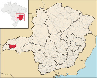
Campina Verde is a municipality in the north of the Brazilian state of Minas Gerais. As of 2020 the population was 19,752 in a total area of 3,663 km². It became a municipality in 1938.

Rio Paranaíba is a Brazilian municipality in the northwest of the state of Minas Gerais. Its population as of 2020 was 12,335 people living in a total area of 1,353 km². The city belongs to the mesoregion of Triângulo Mineiro e Alto Paranaíba and to the microregion of Patos de Minas. It became a municipality in 1923.

Iraí de Minas is a Brazilian municipality located in the northwest of the state of Minas Gerais. Its population as of 2020 was 7,027 people living in a total area of 357 km². The city belongs to the mesoregion of Triângulo Mineiro e Alto Paranaiba and to the microregion of Patrocínio. It became a municipality in 1962.

Serra do Salitre is a Brazilian municipality located in the northwest of the state of Minas Gerais. Its population in 2020 was 11,668 living in a total area of 1,298 km2. The city belongs to the mesoregion of Triângulo Mineiro e Alto Paranaiba and to the microregion of Patrocínio. It became a municipality in 1953.

Delta is a Brazilian municipality located in the west of the state of Minas Gerais. Its population as of 2020 was estimated to be 10,768 people living in a total area of 104 square kilometres (40 sq mi). The city belongs to the mesoregion of Triângulo Mineiro and Alto Paranaíba and to the micro-region of Uberaba. It became a municipality in 1997.

Nova Ponte is a Brazilian municipality located in the west of the state of Minas Gerais. Its population as of 2020 was estimated to be 15,800 people living in a total area of 1,105 km². The city belongs to the mesoregion of Triângulo Mineiro and Alto Paranaíba and to the micro-region of Araxá. It became a municipality in 1938.

Tapira is a Brazilian municipality located in the west of the state of Minas Gerais. Its population as of 2020 was 4,832 people living in a total area of 1,180 km2. The city belongs to the meso-region of Triângulo Mineiro and Alto Paranaíba and to the micro-region of Araxá. It became a municipality in 1963.

