Volta Grande

Last updated
Train station at Volta Grande Volta grande 1.jpg
Train station at Volta Grande

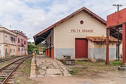
Volta Grande is a Brazilian municipality in the state of Minas Gerais. As of 2020 its population was estimated to be 5,261. [1]

Contents

Geography

Volta Grande is located in the Zona da Mata mesoregion of Minas Gerais near the border with the state of Rio de Janeiro. The city is 352 km (219 mi) by road from the state capital of Belo Horizonte. It lies at an altitude of 210 m (690 ft).

Climate

The climate is tropical with rains during the summer and mean annual temperature around 19 °C (66 °F), with variations between 15 °C (59 °F) (average minimum) and 23 °C (73 °F) (mean maximum).

Hydrography

The rivers Paraiba do Sul and Angu drain the municipality of Volta Grande which is part of the Paraiba do Sul river basin.

History

The town originated from a village formed in 1835 and was elevated to a district of the municipality of Alem Paraíba in 1891. Emancipation came in 1938.

It is the birthplace of film director Humberto Mauro.

Related Research Articles

Municipalities of Brazil State administrative areas in Brazil

The municipalities of Brazil are administrative divisions of the Brazilian states. Brazil currently has 5,570 municipalities, which, given the 2019 population estimate of 210,147,125, makes an average municipality population of 37,728 inhabitants. The average state in Brazil has 214 municipalities. Roraima is the least subdivided state, with 15 municipalities, while Minas Gerais is the most subdivided state, with 853.

Campo Grande Municipality in Center-West, Brazil

Campo Grande is the capital and largest city of the Brazilian state of Mato Grosso do Sul in the Center-West region of the country. The city is nicknamed Cidade Morena because of the reddish-brown colour of the region's soil. It has a population of 906,092, according to a 2020 IBGE estimate, while its metropolitan area is home to 991,420 people (2010).

Cruzeiro, São Paulo Municipality in Southeast Brazil, Brazil

Cruzeiro is a municipality in the state of São Paulo in Brazil. It is located about 220 km (137 mi) from the state capital. It is part of the Metropolitan Region of Vale do Paraíba e Litoral Norte. The population is 82,571 in an area of 305,70 km2.

São João, Portuguese for "Saint John", may refer to:

Lagoa may refer to the following:

Santana may refer to:

Belmiro Braga

Belmiro Braga is a city in the state of Minas Gerais, Brazil close to the border with Rio de Janeiro state. It was emancipated from Juiz de Fora in 1962. As of 2020, the estimated population was 3,425 inhabitants.

Paraíba do Sul River in southeast Brazil

The Paraíba do Sul, or simply termed Paraíba, is a river in southeast Brazil. It flows 1,137 km (706 mi) west to northeast from its farthest source at the source of the river Paraitinga to the sea near Campos dos Goytacazes. The river receives its name when it meets the river Paraibuna at the Paraibuna dam.

Lima Duarte, Minas Gerais Municipality in Southeast, Brazil

Lima Duarte is a municipality in the state of Minas Gerais, Brazil. It has a population of 16,724 inhabitants (2020) and a total area of 848 square kilometres (327 sq mi) and lies at an elevation of 860 metres (2,822 ft) in the foothills of the Mantiqueira Mountains. It was given city status in 1881.

Mantiqueira Mountains

The Mantiqueira Mountains are a mountain range in Southeastern Brazil, with parts in the states of São Paulo, Minas Gerais and Rio de Janeiro. It rises abruptly from the northwestern bank of the Paraíba do Sul River and extends northeastward for approximately 320 km (200 mi), reaching a height of 2,798 m (9,180 ft) at Pedra da Mina. The mountains, which eventually merge with the Serra do Espinhaço, were originally forest-covered, except for the peaks that rise above the tree line. They provide charcoal and pasture for cattle; on the lower slopes there are several health and tourist resorts, such as Campos do Jordão, Brazil's highest city. The name Mantiqueira derives from a Tupi word meaning "mountains that cry", denoting the large number of springs and streams found there.

Purian languages

Purian is a pair of extinct languages of eastern Brazil:

Mining in Brazil is centered on the extraction of iron, copper, gold, aluminum, manganese, tin, niobium, and nickel. About gemstones, Brazil is the world's largest producer of amethyst, topaz, agate and is a big producer of tourmaline, emerald, aquamarine, garnet and opal.

Indaiabira

Indaiabira is a municipality in the northeast of the Brazilian state of Minas Gerais. As of 2020 the population was 7,339 in a total area of 1,008 km². The elevation is 857 meters. It became a municipality in 1997.

Delta, Minas Gerais Municipality in Minas Gerais, Brazil

Delta is a Brazilian municipality located in the west of the state of Minas Gerais. Its population as of 2020 was estimated to be 10,768 people living in a total area of 104 square kilometres (40 sq mi). The city belongs to the mesoregion of Triângulo Mineiro and Alto Paranaíba and to the micro-region of Uberaba. It became a municipality in 1997.

Pirapetinga Municipality in Southeast, Brazil

Pirapetinga is a municipality in the state of Minas Gerais in the Southeast region of Brazil. Its estimated population in 2020 was 10,772 inhabitants (IBGE).

The Angu River is a river in the Brazilian state of Minas Gerais. It is a left bank tributary of the Rio Paraiba do Sul. It is 58 km (36 mi) in length and drains an area of 346 km2 (134 sq mi) .

The Brazilian municipal elections of 2012 took place on October 7 and on October 28. Over 138 million voters chose mayors, deputy mayors and city councillors for the 5,568 municipalities of Brazil. These were the first elections in which the recently registered parties Partido Pátria Livre (PPL) and Partido Social Democrático (PSD) participated; they were both recognized by the Superior Electoral Court in 2011. Political parties whose candidates wished to run for the 2012 elections had to be registered at the TSE for at least one year before the election date, while candidates also had to be affiliated to a party for the same period of time. Conventions for the selection of candidates within the parties occurred between 10 and 30 June, while the registry of candidates and alliances with the Regional Electoral Courts took place until July 5. Electoral campaign was authorized from the moment a candidacy had been registered. The free electoral program – two daily slots on free-to-air TV and radio for political advertising paid by the Electoral Justice fund – ran weekdays from 21 August until 4 October. According to the current Brazilian electoral law, the two-round system – should the leading candidate receive less than 50% +1 of the votes – is only available for cities with more than 200,000 voters. This includes all state capitals, with the exception of Boa Vista, Roraima and Palmas, Tocantins, plus 59 other municipalities. The free electoral program for the second round ran from 13 October until 26 October.

References

Coordinates: 21°46′15″S42°32′20″W / 21.77083°S 42.53889°W / -21.77083; -42.53889