
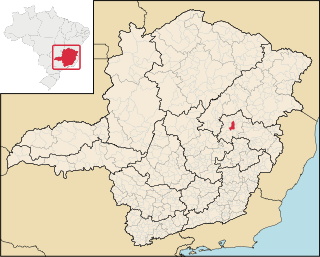
Montes Claros is a city located in northern Minas Gerais state, in Brazil. The population is 413,487 in an area of 3,569 km2 (1,378 sq mi). It was made a seat of a municipality in 1831 and attained city status in 1857.

Mariana is the oldest city in the state of Minas Gerais, Brazil. It is a tourist city, founded on July 16, 1696, and retains the characteristics of a baroque city, with its churches, buildings and museums. It was the first capital of Minas Gerais.

Almenara, is a municipality in the northeast of the Brazilian state of Minas Gerais. Situated on the Jequitinhonha River it is the largest city in that river valley. Its 2020 population was estimated at 42,143 and the municipal area was 2,301 km².
Dois Riachos is a municipality located in the West of the Brazilian state of Alagoas. Its population is 11,067 (2020) and its area is 140 km².

Campo Belo is a city located in Minas Gerais state, in Brazil. The estimated population in 2020 was 54,186 inhabitants, and the total area of the municipality was 528.225 square kilometres (203.949 sq mi). It was founded in 1879.

Baldim is a Brazilian municipality located in the state of Minas Gerais. Its population as of 2020 is estimated to be 7,803, in a total area of 554,029 km2 (213,912 sq mi). The city belongs to the mesoregion Metropolitana de Belo Horizonte and to the microregion of Sete Lagoas.

Confins is a Brazilian municipality located in the state of Minas Gerais. Its population as of 2020 is estimated to be 6,800 people. The area of the municipality is 42.008 km². The city belongs to the mesoregion Metropolitana de Belo Horizonte and to the microregion of Belo Horizonte. It is home of the international airport of Belo Horizonte, Tancredo Neves International Airport.
Pará de Minas is a Brazilian municipality located in the state of Minas Gerais.

Brumadinho is a Brazilian municipality in the state of Minas Gerais. The city belongs to the Belo Horizonte metropolitan mesoregion and to the microregion of Belo Horizonte. Brumadinho is at an altitude of 880 m. In 2020 the population was 40,666. The municipality is on the Paraopeba River.
Entre Rios de Minas is a Brazilian municipality located in the state of Minas Gerais. The city belongs to the mesoregion Metropolitana de Belo Horizonte and to the microregion of Conselheiro Lafaiete.

Bonito de Minas is a municipality in the northeast of the Brazilian state of Minas Gerais. As of 2020 the population was 11,369 in a total area of 3,901 km2. The elevation is 629 meters. It became a municipality in 1995.
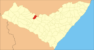
Caetés is a Brazilian municipality located within the state of Pernambuco, in northeastern Brazil. The city belongs to the mesoregion of Agreste Pernambucano and microregion of Garanhuns. It is the birthplace of former president of Brazil Luiz Inácio Lula da Silva. The name originates from the indigenous Caetés people who lived in Pernambuco in the 16th century.

Cláudio is a municipality in the state of Minas Gerais in the Southeast region of Brazil.

Itaúna is a municipality in the state of Minas Gerais in the Southeast region of Brazil.
Ibitiúra de Minas is a municipality in the state of Minas Gerais in the Southeast region of Brazil.Its estimated population in 2020 was 3,492 inhabitants.
Lambari is a municipality in the state of Minas Gerais in the Southeast region of Brazil.
São João Evangelista is a municipality in the state of Minas Gerais in the Southeast region of Brazil.

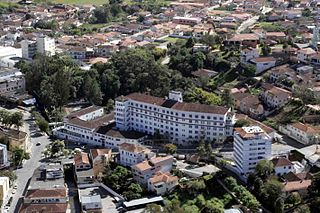
Peçanha is a municipality in the state of Minas Gerais in the Southeast region of Brazil.

Ewbank da Câmara is a municipality in the state of Minas Gerais, Brazil. Belonging to the mesoregion of the Zona da Mata and the microregion of Juiz de Fora, the municipality is located some 241 km to the southeast of the state capital, Belo Horizonte. In 2020, its population was 3,923, according to the Brazilian Institute of Geography and Statistics. It occupies an area of 103.834 km². The urban area of the municipality constitutes a small part of the total. The rural area, predominantly in the municipality, has Atlantic rainforest vegetation.

Rio Preto is a municipality in the state of Minas Gerais in the Southeast region of Brazil.


