Caldas, Minas Gerais

Last updated
Caldas
Municipality
PANORAMICA CALDAS MG.jpg
BANDEIRA DE CALDAS 20X14-01.png
Caldasmgbrasao.png
Brazil location map.svg
Red pog.svg
Caldas
Location in Brazil
Coordinates: 21°55′26″S46°23′9″W / 21.92389°S 46.38583°W / -21.92389; -46.38583
CountryFlag of Brazil.svg  Brazil
Region Southeast
State Minas Gerais
MesoregionSudoeste de Minas
Microregion Poços de Caldas
Government
  MayorUlisses Guimarães Borges (PTB)
Population
 (2020 [1] )
  Total14,541
Time zone UTC−3 (BRT)

Caldas is a municipality in the state of Minas Gerais in the Southeast region of Brazil. [2] [3] [4] [5]

See also

Related Research Articles

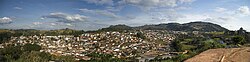
Conceição da Aparecida is a municipality in the state of Minas Gerais in the Southeast region of Brazil.

<span class="mw-page-title-main">Divisa Nova</span> Municipality in Southeast, Brazil

Divisa Nova is a municipality in the state of Minas Gerais in the Southeast region of Brazil.

Bom Repouso is a municipality in the state of Minas Gerais in the Southeast region of Brazil.

<span class="mw-page-title-main">Cambuí Municipality</span> Municipality in Southeast, Brazil

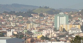
Cambuí is a municipality in the state of Minas Gerais in the Southeast region of Brazil.

<span class="mw-page-title-main">Córrego do Bom Jesus</span> Municipality in Southeast, Brazil

Córrego do Bom Jesus is a municipality in the state of Minas Gerais in the Southeast region of Brazil.

<span class="mw-page-title-main">Extrema, Minas Gerais</span> Municipality in Southeast, Brazil

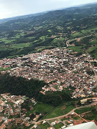
Extrema is a municipality in the state of Minas Gerais in the Southeast region of Brazil.

<span class="mw-page-title-main">Ipuiúna</span> Municipality in Southeast, Brazil

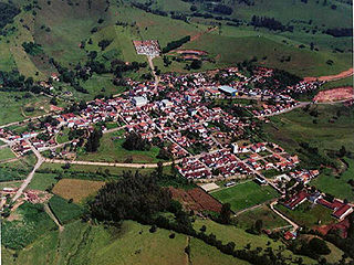
Ipuiúna is a municipality in the state of Minas Gerais in the Southeast region of Brazil.

Munhoz is a municipality in the state of Minas Gerais in the Southeast region of Brazil.

Senador José Bento is a municipality in the state of Minas Gerais in the Southeast region of Brazil.

Toledo, Minas Gerais is a municipality in the state of Minas Gerais in the Southeast region of Brazil.

São Sebastião da Bela Vista is a municipality in the state of Minas Gerais in the Southeast region of Brazil.

<span class="mw-page-title-main">Juruaia</span> Municipality in Southeast, Brazil

Juruaia is a municipality in the state of Minas Gerais in the Southeast region of Brazil.

Monte Belo is a municipality in the state of Minas Gerais in the Southeast region of Brazil.

Monsenhor Paulo is a municipality in the state of Minas Gerais in the Southeast region of Brazil.

Vargem Alegre is a municipality in the state of Minas Gerais in the Southeast region of Brazil.

Sardoá is a municipality in the state of Minas Gerais in the Southeast region of Brazil.

<span class="mw-page-title-main">Periquito</span> Municipality in Southeast, Brazil

Periquito is a municipality in the state of Minas Gerais in the Southeast region of Brazil.

São Félix de Minas is a municipality in the state of Minas Gerais in the Southeast region of Brazil.

São João do Manteninha is a municipality in the state of Minas Gerais in the Southeast region of Brazil.

<span class="mw-page-title-main">Bias Fortes</span> Municipality in Southeast, Brazil

Bias Fortes is a municipality in the state of Minas Gerais in the Southeast region of Brazil.

References

  1. IBGE 2020
  2. "Divisão Territorial do Brasil" (in Portuguese). Divisão Territorial do Brasil e Limites Territoriais, Instituto Brasileiro de Geografia e Estatística (IBGE). July 1, 2008. Retrieved December 17, 2009.
  3. "Estimativas da população para 1º de julho de 2009" (PDF) (in Portuguese). Estimativas de População, Instituto Brasileiro de Geografia e Estatística (IBGE). August 14, 2009. Retrieved December 17, 2009.
  4. "Ranking decrescente do IDH-M dos municípios do Brasil" (in Portuguese). Atlas do Desenvolvimento Humano, Programa das Nações Unidas para o Desenvolvimento (PNUD). 2000. Archived from the original on October 3, 2009. Retrieved December 17, 2009.
  5. "Produto Interno Bruto dos Municípios 2002-2005" (PDF) (in Portuguese). Instituto Brasileiro de Geografia e Estatística (IBGE). December 19, 2007. Archived from the original (PDF) on October 2, 2008. Retrieved December 17, 2009.

21°55′26″S46°23′09″W / 21.92389°S 46.38583°W / -21.92389; -46.38583