
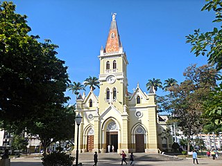
Visconde do Rio Branco is a Brazilian municipality in the state of Minas Gerais. As of 2020 its population is estimated to be 42,965. [1]
Visconde do Rio Branco is a Brazilian municipality in the state of Minas Gerais. As of 2020 its population is estimated to be 42,965. [1]
The Purian languages, now extinct, were formerly spoken in and around what is now Visconde do Rio Branco. [2]
Visconde do Rio Branco was founded in 1810 and had been called by the name "São João". The little village was growing up till 1839 when it finally was recognized as a true village. At 1881 was elevated to City and subordinate to Ubá (the most industrial city of the micro-region) and it received the actual name Visconde do Rio Branco.
The city is based on an agrarian economy. Sugarcane plantations was a great attractive factor of the progress of all the farms and industry of the city.
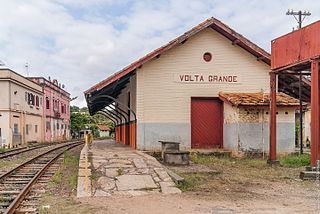
Volta Grande is a Brazilian municipality in the state of Minas Gerais. As of 2020 its population was estimated to be 5,261.

Bom Jardim de Minas is a city of the state of Minas Gerais, Brazil.

Zona da Mata is a mesoregion of the state of Minas Gerais, Brazil, situated in the southeastern part of the state, along the border of the states of Minas Gerais, Rio de Janeiro and Espírito Santo. The region has a lot of hills, and the heights varies from 100 to 1,900 meters. The most important river is the Paraíba do Sul.
Maxakalí is a Maxakalían language spoken in four villages in Minas Gerais, Brazil, by more than 2,000 people.

The Maxakalían languages were first classified into the Jê languages. It was only in 1931 that Čestmír Loukotka separated them from the Jê family. Alfred Métraux and Curt Nimuendajú considered the Maxakalían family isolated from others. John Alden Mason suggests a connection with the Macro-Jê stock, confirmed by Aryon Rodrigues.
Rio Branco or Río Branco may refer to:
Caratinga is a municipality in eastern Minas Gerais state, Brazil. The population in 2020 was 92,603 inhabitants and the total area of the municipality was 1,251 km2. The elevation is 578 meters above sea level, with maximum elevation of 1,516 m in the Serra do Rio Preto and 330 m at the mouth of the Córrego Boachá.

Purian is a pair of extinct languages of eastern Brazil:
Xakriabá is an extinct or dormant Akuwẽ language formerly spoken in Minas Gerais, Brazil by the Xakriabá people, who today speak Portuguese. The language is known through two short wordlists collected by Augustin Saint-Hilaire and Wilhelm Ludwig von Eschwege.

Miraí is a Brazilian municipality located in the state of Minas Gerais. The city belongs to the mesoregion of Zona da Mata and to the microregion of Muriaé.

Santo Antônio do Retiro is a city in the northeast of the Brazilian state of Minas Gerais. In 2020 its population was estimated to be 7,297 in a total area of 797 km².
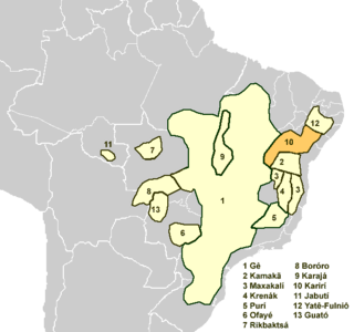
The Karirí languages, generally considered dialects of a single language, were a group of languages formerly spoken by the Kiriri people of Brazil. It was spoken until the middle of the 20th century; the 4,000 ethnic Kiriri are now monolingual Portuguese speakers, though a few know common phrases and names of medicinal plants.

The Rio Pomba is a river of Minas Gerais and Rio de Janeiro states in southeastern Brazil, one of the principle tributaries of the Paraíba do Sul.

Pirapetinga is a municipality in the state of Minas Gerais in the Southeast region of Brazil. Its estimated population in 2020 was 10,772 inhabitants (IBGE).

The Kamakã languages are a small family of extinct Macro-Jê languages of Bahía, northeastern Brazil. The attested Kamakã languages are:
Pataxó (Patashó), or Pataxó Hã-Ha-Hãe (Pataxó-Hãhaãi), is an extinct Maxakalían language of Brazil formerly spoken by the Pataxó people of the Bahia region, and of Minas Gerais, Pôsto Paraguassu in Itabuna municipality. The 2,950 individuals in the Pataxó tribe now speak Portuguese instead, though they retain a few Pataxó words, as well as some words from neighbouring peoples.

Koropó (Coropó) is an extinct language of eastern Brazil. It has been variously classified as a Maxakalían or a Purian language.
Malalí is an extinct Maxakalian language of Brazil.

The Immediate Geographic Region of Ubá is one of the 10 immediate geographic regions in the Intermediate Geographic Region of Juiz de Fora, one of the 70 immediate geographic regions in the Brazilian state of Minas Gerais and one of the 509 of Brazil, created by the National Institute of Geography and Statistics (IBGE) in 2017.
21°00′37″S42°50′26″W / 21.0102777878°S 42.8405555656°W
| International | |
|---|---|
| National | |
| | This geographical article relating to Minas Gerais is a stub. You can help Wikipedia by expanding it. |
