Conselheiro Lafaiete

Last updated
Conselheiro Lafaiete
Municipality of Conselheiro Lafaiete
Conselheiro Lafaiete Minas.jpg
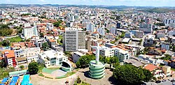
View of Conselheiro Lafaiete
Bandeira-conselheirolafaiete.png
Brasaolafaiete.png
MinasGerais Municip ConselheiroLafaiete.svg
Location in Minas Gerais
Coordinates: 20°39′36″S43°47′09″W / 20.66000°S 43.78583°W / -20.66000; -43.78583
CountryFlag of Brazil.svg  Brazil
State Bandeira de Minas Gerais.svg  Minas Gerais
Region Southeast
Intermediate Region Barbacena
Immediate Region Conselheiro Lafaiete
Area
[1]
  Total370.246 km2 (142.953 sq mi)
Elevation
995 m (3,264 ft)
Population
 (2020 est.) [2]
  Total129,606
  Density350/km2 (910/sq mi)
Time zone UTC−3 (BRT)

Conselheiro Lafaiete is a city of the state of Minas Gerais, Brazil. It was known as Queluz until 1934, when it was renamed by decree, as a tribute to Counselor Lafayette Rodrigues Pereira.

Contents

It is situated 96 km south from Belo Horizonte, capital of Minas Gerais, in one of the most important economic areas of Brazil. The population was 129,606 inhabitants, in 2020. [2] It is one of the most populated cities of Minas Gerais. [3]

Geography

According to the modern (2017) geographic classification by Brazil's National Institute of Geography and Statistics (IBGE), the municipality belongs to the Immediate Geographic Region of Conselheiro Lafaiete, in the Intermediate Geographic Region of Barbacena. [4]

See also

Related Research Articles

<span class="mw-page-title-main">São João del-Rei</span> Municipality in Minas Gerais, Brazil

São João del-Rei is a Brazilian municipality in the state of Minas Gerais. Founded in 1713 in homage to king John V of Portugal, the city is famed for its historic Portuguese colonial architecture. The current population is estimated at 90,225 inhabitants.

<span class="mw-page-title-main">Ribeirão das Neves</span> Place in Brazil

Ribeirão das Neves is a Brazilian municipality located in the state of Minas Gerais. The city belongs to the mesoregion Metropolitana de Belo Horizonte and to the microregion of Belo Horizonte. Most residents commute to Belo Horizonte. The population in 2020 was 338,197.

<span class="mw-page-title-main">Ouro Branco, Minas Gerais</span> Municipality in Southeast, Brazil

Ouro Branco is a Brazilian municipality located in the state of Minas Gerais. The city belongs to the Mesoregion Metropolitana de Belo Horizonte and to the Microregion of Conselheiro Lafaiete. As of 2020, the city has a population of 39,867 inhabitants. The name "Ouro Branco" means "White Gold", as opposed to "Black Gold" - Ouro Preto. The city was an important base on the transportation route from the mines of Minas Gerais to the coast.

<span class="mw-page-title-main">Araçuaí</span> Place in Brazil

Araçuaí is a Brazilian municipality located in the northeast of the state of Minas Gerais in the Jequitinhonha River valley. The Araçuaí River, a tributary of the Jequitinhonha, flows through it. Its population as of 2020 was estimated to be 36,712 people living in a total area of 2,235 km2. The city belongs to the mesoregion of Jequitinhonha and to the microregion of Araçuaí. The city is the seat of the Roman Catholic Diocese of Araçuaí. The elevation of the municipal seat is 307 meters. It became a municipality in 1870.

<span class="mw-page-title-main">Casa Grande, Minas Gerais</span> Town and municipality in the state of Minas Gerais, Brazil

Casa Grande is a Brazilian municipality located in the state of Minas Gerais. The city belongs to the mesoregion Metropolitana de Belo Horizonte and to the microregion of Conselheiro Lafaiete. As of 2020, the estimated population was 2,254.

<span class="mw-page-title-main">Catas Altas da Noruega</span> Municipality of Brazil

Catas Altas da Noruega is a Brazilian municipality located in the state of Minas Gerais. The city belongs to the mesoregion Metropolitana de Belo Horizonte and to the microregion of Conselheiro Lafaiete. As of 2020, the estimated population was 3,653.

<span class="mw-page-title-main">Cristiano Otoni</span> Town and municipality in the state of Minas Gerais, Brazil

Cristiano Otoni is a Brazilian municipality located in the state of Minas Gerais. The city belongs to the mesoregion Metropolitana de Belo Horizonte and to the microregion of Conselheiro Lafaiete. As of 2020, the estimated population was 5,156.

<span class="mw-page-title-main">Desterro de Entre Rios</span> Town and municipality in the state of Minas Gerais, Brazil

Desterro de Entre Rios is a Brazilian municipality located in the state of Minas Gerais. The city belongs to the mesoregion Metropolitana de Belo Horizonte and to the microregion of Conselheiro Lafaiete. As of 2020, the estimated population was 7,255.

<span class="mw-page-title-main">Entre Rios de Minas</span> Place in Southeast, Brazil

Entre Rios de Minas is a Brazilian municipality located in the state of Minas Gerais. The city belongs to the mesoregion Metropolitana de Belo Horizonte and to the microregion of Conselheiro Lafaiete.

<span class="mw-page-title-main">Queluzito</span> Human settlement in Brazil

Queluzito is a Brazilian municipality located in the state of Minas Gerais. The city belongs to the mesoregion Metropolitana de Belo Horizonte and to the microregion of Conselheiro Lafaiete. As of 2020, the estimated population was 1,943.

<span class="mw-page-title-main">Santana dos Montes</span> Human settlement in Brazil

Santana dos Montes is a Brazilian municipality located in the state of Minas Gerais. The city belongs to the mesoregion Metropolitana de Belo Horizonte and to the microregion of Conselheiro Lafaiete. As of 2020, the estimated population was 3,765.

<span class="mw-page-title-main">São Brás do Suaçuí</span> Brazilian municipality

São Brás do Suaçuí is a Brazilian municipality located in the state of Minas Gerais. The city belongs to the mesoregion Metropolitana de Belo Horizonte and to the microregion of Conselheiro Lafaiete. As of 2020, the estimated population was 3,754.

<span class="mw-page-title-main">Caraí</span> Place in Brazil

Caraí is a Brazilian municipality located in the northeast of the state of Minas Gerais. Its population as of 2020 was estimated to be 23,780 people living in a total area of 1,240 km2. The city belongs to the mesoregion of Jequitinhonha and to the microregion of Araçuaí. The elevation of the municipal seat is 750 meters. It became a municipality in 1948.

<span class="mw-page-title-main">Bonfinópolis de Minas</span> Human settlement in Brazil

Bonfinópolis de Minas is a municipality in the north of the Brazilian state of Minas Gerais. The population of the municipality in 2020 by the Brazilian Institute of Geography and Statistics (IBGE) is 5,444 inhabitants in a total area of 1,778 km2. The elevation of the municipal seat is 651. It became a city in 1962.

<span class="mw-page-title-main">Miravânia</span> Place in Brazil

Miravânia is a municipality in the north of the state of Minas Gerais in Brazil. As of 2020 the population was 4,914 in an area of 603 km². It is located on the left bank of the São Francisco River. It is connected by dirt road to São João das Missões by paved BR-135. The distance is 112 km. Neighboring municipalities are: Montalvânia, Manga, Cônego Marinho, and São João das Missões.

Santa Vitória is a municipality in the west of the Brazilian state of Minas Gerais. As of 2020, the population was estimated at 19,872. It became a municipality in 1948.

<span class="mw-page-title-main">Intermediate Geographic Region of Barbacena</span> Interurban administrative region in Minas Gerais, Brazil

The Intermediate Geographic Region of Barbacena is one of the 13 intermediate geographic regions in the Brazilian state of Minas Gerais and one of the 134 of Brazil, created by the National Institute of Geography and Statistics (IBGE) in 2017.

<span class="mw-page-title-main">Intermediate Geographic Region of Uberaba</span> Interurban administrative region in Minas Gerais, Brazil

The Intermediate Geographic Region of Uberaba is one of the 13 intermediate geographic regions in the Brazilian state of Minas Gerais, as well as one of the 134 regions in Brazil. It was designated by the National Institute of Geography and Statistics (IBGE) in 2017.

<span class="mw-page-title-main">Immediate Geographic Region of Conselheiro Lafaiete</span> Urban administrative region in Minas Gerais, Brazil

The Immediate Geographic Region of Conselheiro Lafaiete is one of the 10 immediate geographic regions in the Intermediate Geographic Region of Barbacena, one of the 70 immediate geographic regions in the Brazilian state of Minas Gerais and one of the 509 of Brazil, created by the National Institute of Geography and Statistics (IBGE) in 2017.

<span class="mw-page-title-main">Immediate Geographic Region of Governador Valadares</span> Urban administrative region in Minas Gerais, Brazil

The Immediate Geographic Region of Governador Valadares is one of the 4 immediate geographic regions in the Intermediate Geographic Region of Governador Valadares, one of the 70 immediate geographic regions in the Brazilian state of Minas Gerais and one of the 509 of Brazil, created by the National Institute of Geography and Statistics (IBGE) in 2017.

References

  1. "Brazilian Institute of Geography and Statistics" (in Portuguese). 2017. Retrieved 27 March 2019. 2018 Area Total
  2. 1 2 IBGE 2020
  3. "Resident population, by sex and urban or rural situation, resident population 10 years old and over, total, literate and literacy rate, in accordance to municipalities" (Table). Censo Demográfico 2000. Instituto Brasileiro de Geografia e Estatística. Retrieved 2007-09-02.
  4. "Divisões Regionais do Brasil | IBGE". www.ibge.gov.br. Retrieved 2022-06-24.