The Dells of the Wisconsin River, also called the Wisconsin Dells, is a 5-mile (8-km) gorge on the Wisconsin River in south-central Wisconsin, USA. It is noted for its scenic beauty, in particular for its unique Cambrian sandstone rock formations and tributary canyons.
Gorges State Park is a 7,709-acre (31.20 km2) North Carolina state park in Transylvania County, North Carolina in the United States and along with other conservation lands is part of a 100,000+ acre conservation corridor stretching some 80 miles along the NC/SC state line. The land, along Jocassee Gorges, was purchased by the state from Duke Energy Corporation in 1999. It is North Carolina's westernmost state park and one of the state's newest. The park is adjacent to part of the Pisgah National Forest and the N.C. Wildlife Resources Commission's Toxaway Game Land. Gorges State Park provides the principal access to the Horsepasture River on these adjoining public lands.

Devil's Lake State Park is a state park located in the Baraboo Range in eastern Sauk County, just south of Baraboo, Wisconsin. It is around thirty-five miles northwest of Madison, and is on the western edge of the last ice-sheet deposited during the Wisconsin glaciation. The state park encompasses 9,217 acres (3,730 ha), making it the largest in Wisconsin. The state park is known for its 500-foot-high (150 m) quartzite bluffs along the 360-acre (150 ha) Devil's Lake, which was created by a glacier depositing terminal moraines that plugged the north and south ends of the gap in the bluffs during the last ice age approximately 12,000 years ago. The sand at the bottom of Devil's Lake is thought to be deposited by glaciers.
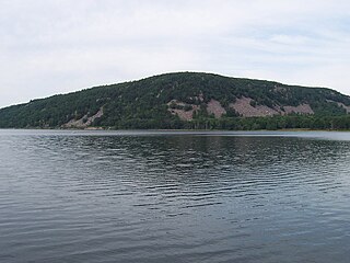
Devil's Lake is a lake in the South Range of the Baraboo Range, about two miles south of Baraboo, Wisconsin, in Sauk County, Wisconsin, USA. It has no surface outlets, so by some definitions, it is endorheic; however, it possibly drains by underground channels into the Baraboo River, which would make the lake cryptorheic. The lake is one of the primary attractions of Devil's Lake State Park. It is also a popular recreation destination for watercraft, fishing, hiking, and climbing.

The Wisconsin Department of Natural Resources (WDNR) is a government agency of the U.S. state of Wisconsin charged with conserving and managing Wisconsin's natural resources. The Wisconsin Natural Resources Board has the authority to set policy for the WDNR. The WDNR is led by the Secretary, who is appointed by the Governor of Wisconsin. The WDNR develops regulations and guidance in accordance with laws passed by the Wisconsin Legislature. It administers wildlife, fish, forests, endangered resources, air, water, waste, and other issues related to natural resources. The central office of the WDNR is located in downtown Madison, near the state capitol.

Wyalusing State Park is a 2,628-acre (1,064 ha) Wisconsin state park at the confluence of the Mississippi and Wisconsin rivers in the town of Wyalusing, just south of Prairie du Chien.

Newport State Park is a 2,373-acre (960 ha) Wisconsin state park at the tip of Door Peninsula near Europe Lake. Protecting 11 miles (18 km) of shoreline on Lake Michigan, Newport is Wisconsin's only wilderness-designated state park. The park is open year-round and can be accessed via WIS 42.

Mirror Lake State Park is a 2,179-acre (882 ha) Wisconsin state park in the Wisconsin Dells region. The process of establishing the park began in 1962 and the park officially opened on August 19, 1966. It contains Mirror Lake, a narrow reservoir with steep sandstone sides up to 50 feet (15 m) tall. The lake has a surface area of 137 acres (55 ha) and an average depth of 10 to 14 feet. Recessed out of the wind, the water of Mirror Lake is usually calm and often as glassy-smooth as a mirror, hence the name. Situated in a major tourist area, the state park has an extensive campground and other visitor amenities. Also located within the park is the Seth Peterson Cottage, a Frank Lloyd Wright-designed building available for public rental.

Rocky Arbor State Park is a 244-acre (99 ha) Wisconsin state park in the Wisconsin Dells region. The park was established in 1932 to protect sandstone outcrops eroded into picturesque walls and ledges.

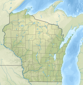
Wisconsin, a state in the Midwestern United States, has a vast and diverse geography famous for its landforms created by glaciers during the Wisconsin glaciation 17 thousand years ago. The state can be generally divided into five geographic regions—Lake Superior Lowland, Northern Highland, Central Plain, Eastern Ridges & Lowlands, and Western Upland. The southwestern part of the state, which was not covered by glaciers during the most recent ice age, is known as the Driftless Area. The Wisconsin glaciation formed the Wisconsin Dells, Devil's Lake, and the Baraboo Range. A number of areas are protected in the state, including Devil's Lake State Park, the Apostle Islands National Lakeshore, and the Chequamegon–Nicolet National Forest.

Kohler-Andrae State Park comprises two adjacent Wisconsin state parks located in the Town of Wilson, a few miles south of the city of Sheboygan. They are managed as one unit. Terry Andrae State Park, established in 1927, and John Michael Kohler State Park, established in 1966, total 988 acres (4.00 km2). The parks contain over two miles (3 km) of beaches and sand dunes along the shore of Lake Michigan, with woods and wetlands away from the water. The Black River flows through the parks.
Pewit's Nest State Natural Area is a nature reserve of Wisconsin, USA, that includes a deep gorge formed during the retreat of the last glacier. Pewit's Nest is outside Baraboo in Sauk County. At one time a waterwheel and mill were located on the site and an individual lived in the solid sandstone. The name of the site was a result of early settlers calling it "Peewit's Nest" after the abode, ten feet above a deep pool of water, resembling the nest of a phoebe. The water-wheel once turned lathes for repairing or manufacturing equipment, but no evidence of it remains. Pewit's Nest is owned by the Wisconsin Department of Natural Resources and was designated a State Natural Area in 1985.

Woodman Hollow State Preserve is located in Webster County, Iowa, 7 miles (11 km) southeast of Fort Dodge and 6 miles (9.7 km) northwest of Lehigh. The preserve is a satellite area of Dolliver Memorial State Park, located 2 miles to the south. Some older maps refer to the area as "Woodman's Hollow State Park."
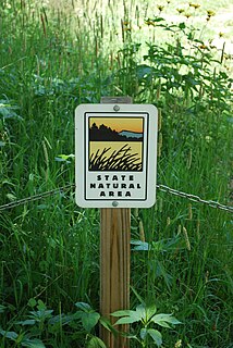
The Wisconsin State Natural Areas Program is a conservation program created to highlight and protect areas with outstanding natural or archaeological resources in the U.S. state of Wisconsin. There are currently 687 State Natural Areas (SNAs) encompassing almost 400,000 acres (160,000 ha). SNAs protect natural communities, geological formations, and archaeological sites for research purposes and as refuges for biodiversity and endangered or threatened species.

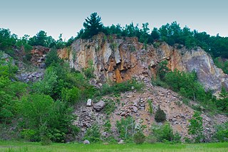
Brady's Bluff Prairie State Natural Area is a Wisconsin Department of Natural Resources-designated State Natural Area featuring a steep, southwest-facing bluff rising over 450 feet above the Mississippi River. Over 100 species of prairie plants have been found at this site.

Trempealeau Mountain State Natural Area is a Wisconsin Department of Natural Resources-designated State Natural Area consisting of a 425-foot conical rock mound surrounded on three sides by the Mississippi and Trempealeau Rivers. It is one of only 3 solid rock islands along the entire Mississippi River.

Brule Glacial Spillway is a Wisconsin Department of Natural Resources-designated State Natural Area that encompasses the valley of the upper reaches of the Bois Brule River. This valley was carved by the outlet of Glacial Lake Duluth, which occupied what is now the western portion of Lake Superior, during the retreat of the Superior lobe of Wisconsin glaciation. This outlet flowed southwestward through the valley, to what is now the St. Croix River. As the glacier melted, and the level of Lake Superior dropped, the direction of flow shifted to its present northeastward course, towards Lake Superior. A high point in a vast bog near Solon Springs marks the Saint Lawrence River Divide between the watersheds of the Gulf of Mexico and the Atlantic Ocean. This divide was used for thousands of years, by Native Americans, European explorers, fur traders, and settlers as a portage between the two watersheds.

The Southern Unit of the Kettle Moraine State Forest includes more than 22,000 acres of land throughout southern Wisconsin and spans several state parks and natural areas. The area also features varied environments from restored prairie, forests, and lakes, along with providing a multitude of recreational opportunities such as hiking, birdwatching, fishing, camping, and hunting. The Kettle Moraine Scenic Drive also extends within this region as well as through a larger portion of the state.
Norman Carter Fassett was an American botanist and professor, known as an expert on the aquatic flora of Wisconsin.
Ableman's Gorge is a 127 acres (51 ha) Wisconsin State Natural Area located near Rock Springs, Wisconsin. This 200 to 400-foot wide and 200-foot high gorge is cut by about 1 mile (1.6 km) of the Baraboo River in an "L" shape. The Natural Area is named after George Ableman who settled Rock Springs in 1851 and named the community after the gorge area.
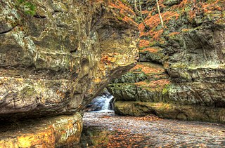
 Walls of Parfrey's Glen
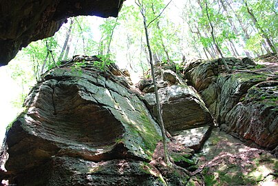 View from the Glen
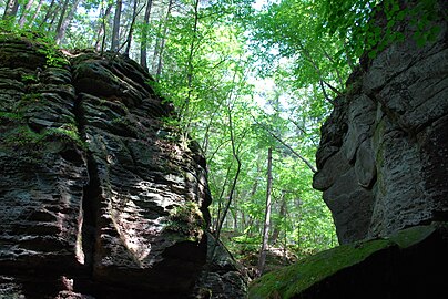 Parfrey's Glen
 Parfrey's Glen
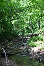 Parfrey's Glen Creek